NASA
NASA Science
Mars Exploration Program
Skip Navigation
menu
Images
Meridiani Planum
August 24, 2004
Credits
NASA/JPL/Arizona State University
ENLARGE
[51, 179]
Related
These three views of the Martian moon Phobos were taken by NASA's 2001 Mars Odyssey orbiter using its infrared camera, THEMIS. Each color represents a different temperature range.
Odyssey's Three Views of Phobos
This image superimposes Gamma-Ray Spectrometer data from NASA's Mars Odyssey orbiter onto topographic data from the laser altimeter on NASA's Mars Global Surveyor.
Potassium Concentrations on Mars
NASA's Mars Odyssey spacecraft passes above Mars' south pole in this artist's concept illustration. The spacecraft has been orbiting Mars since October 24, 2001.
Odyssey over Mars' South Pole
This unnamed channel drains part of Margaritifer Terra.
Channel in Margaritifer Terra.
NASA's Phoenix Mars Lander, its backshell and its heatshield are visible within this enhanced-color image of the Phoenix landing site taken on Jan. 6, 2010 by the High Resolution Imaging Science Ex...
Phoenix Lander Amid Disappearing Spring Ice
This image is near the southern edge of a low, broad volcanic feature called Syrtis Major.
Syrtis Major
This graphic depicts the relative shapes and distances from Mars for five active orbiter missions plus the planet's two natural satellites. It illustrates the potential for intersections of the spa...
Diverse Orbits Around Mars
Mars Odyssey Project Manager Gaylon McSmith, of NASA's Jet Propulsion Laboratory
Mars Odyssey Project Manager Gaylon McSmith
This image combines two products from the first pointing at the Martian moon Phobos by the THEMIS camera on NASA's Mars Odyssey orbiter, on Sept. 29, 2017. Surface-temperature information from obse...
Temperature Gradient on Martian Moon Phobos
Valles Marineris, the "Grand Canyon of Mars," sprawls wide enough to reach from Los Angeles to nearly New York City, if it were located on Earth. The red outline box shows the location of a second,...
Valles Marineris, the "Grand Canyon of Mars"
Mars radiation levels are two to three times higher than around Earth.
Mars radiation levels
Five decades of successful NASA missions to the Red Planet, 1965-2015.
50 Years of Mars Exploration
Artist's concept of future humans on Mars.
Artist's concept of future humans on Mars.
How can you communicate with Mars spacecraft when the Sun is in the way? Learn more about 'solar conjunction' in this 60-second video.
Mars in a Minute: What Happens When the Sun Blocks our Signal?
2021_WindingTributary.jpg
Winding Side Canyon (Louros Valles)
This false color image shows a region with craters of different ages located at the margin of Acidalia Planitia. This image was collected during the Northern Spring season.
Cratered Acidalia Planitia
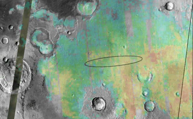
Valleys much younger than well-known ancient valley networks on Mars are evident near the informally named "Heart Lake" on Mars. This map presents color-coded topographical information overlaid ont...
Landscape of Former Lakes and Streams on Northern Mars
The dunes in this VIS image are located in Aonia Terra.
Dunes in Aonia Terra
How do you converse with a robot nearly one hundred million miles away? In this video, Odyssey team members describe communications with the 2001 Mars Odyssey spacecraft using the antennas of the D...
Challenges of Getting to Mars: Telecommunications
A small impact crater on Mars named Gratteri, 4.3 miles (6.9 km) wide, lies at the center of large dark streaks.
Mars Impact Crater Gratteri
Planum Boreum crater
Planum Boreum crater
Six views of the Martian moon Phobos captured by NASA's Odyssey orbiter as of March 2020. The orbiter's THEMIS camera is used to measure temperature variations that suggest what kind of material th...
Odyssey's Six Views of Phobos
NASA's 2001 Mars Odyssey orbiter arrived at Mars on Oct. 24, 2001.
Mars Odyssey Orbiter By the Numbers
This false-color map shows the area within Gale Crater on Mars, where NASA's Curiosity rover landed on Aug. 5, 2012 PDT (Aug. 6, 2012 EDT) and the location where Curiosity collected its first drill...
Location of John Klein Drill Site
This image captured by NASA's 2001 Mars Odyssey spacecraft shows a section of Nanedi Valles, located in Xanthe Terra.
Nanedi Valles
You Might Also Like
The agency established the board in May 2023 to evaluate the technical, cost, and schedule plans prior to confirmation of the mission’s design.
NASA Releases Independent Review's Mars Sample Return Report
A pair of quakes in 2021 sent seismic waves deep into the Red Planet’s core, giving scientists the best data yet on its size and composition.
NASA InSight Study Provides Clearest Look Ever at Martian Core
Ten sample tubes, capturing an amazing variety of Martian geology, have been deposited on Mars’ surface so they could be studied on Earth in the future.
NASA's Perseverance Rover Completes Mars Sample Depot
Filled with rock, the sample tube will be one of 10 forming a depot of tubes that could be considered for a journey to Earth by the Mars Sample Return campaign.
NASA's Perseverance Rover Deposits First Sample on Mars Surface
The mission has concluded that the solar-powered lander has run out of energy after more than four years on the Red Planet.
NASA Retires InSight Mars Lander Mission After Years of Science
The 10 sample tubes being dropped on Mars’ surface so they can be studied on Earth in the future carry an amazing diversity of Red Planet geology.
NASA's Perseverance Rover to Begin Building Martian Sample Depot