September 12, 2017

Sols 1811-1814: Mars of Many Colors

Written by Joseph Battalio

Today was an exciting day of planning as Curiosity continued her ascent up Vera Rubin Ridge. The focus of the weekend plan was on carefully documenting the changes in stratigraphy as we leave the Murray bedrock. Fortunately, we are privy to a bevy of interesting targets and contrasting colors.

On the first sol of the plan, GEO concentrated on planning contact science with the rover arm and was eager to target purple (yes, not red, but purple) and tan facies of the exposed bedrock. As an atmospheric scientist, such an astounding set of contrasting tones catches even my attention. Many of the observations in the plan will be focused on determining the exact structure and composition of the purple rocks and how composition changes between purple and tan. "Sasanoa" is a tan, homogeneous target, and GEO planned MAHLI and APXS observations to assess grain size and composition. MAHLI and APXS will also target "Kemps Folly," which is a purple toned rock with fine banding. MAHLI alone will take a mosaic of "Mount Ephraim," which is a dark purple section of bedrock pictured in the bottom center of the above image, to assess sedimentary structures.

On the second sol (Sol 1812) ChemCam and Mastcam will complement the previous sol's contact science by observing both Sasanoa and Kemps Folly. ChemCam will then target the dark purple section of bedrock imaged by MAHLI, Mount Ephraim. Next, ChemCam will target "Mount Coe," which is a target that looks across the purple to tan colored bedrock contact to better characterize the composition in the transition between the bedrock tones. Mastcam will take stereo imaging of Mount Coe and "Two Brush Reef" to check for dips in the rock faces. Finally, Mastcam will image "Pettegrove Point" to further scout out Vera Rubin Ridge. After this, an approximately 5.5 m drive is planned to move further up Vera Rubin Ridge.

On the third sol (Sol 1813), the only GEO observation is an AEGIS automated ChemCam activity.

As ESTLK, my last day of operations consisted of planning an ENV morning imaging suite on the morning of Sol 1813, which will contain a Mastcam tau and LOS extinction measurement and two Navcam cloud movies, a supra-horizon movie and a zenith movie. Afternoon tau and LOS measurements will be repeated to check for diurnal variability in the amount of atmospheric dust. In addition, Navcam will make an LOS measurement for comparison to Mastcam values. REMS will fit in 24 extended, hour-long blocks, including four HRIM (High Resolution Interval Mode for humidity) measurements, and DAN will take the usual passive and post-drive active measurements.

September 12, 2017

Sol 1814: Spectacular views

Written by Rachel Kronyak, Planetary Geologist at NASA's Jet Propulsion Laboratory

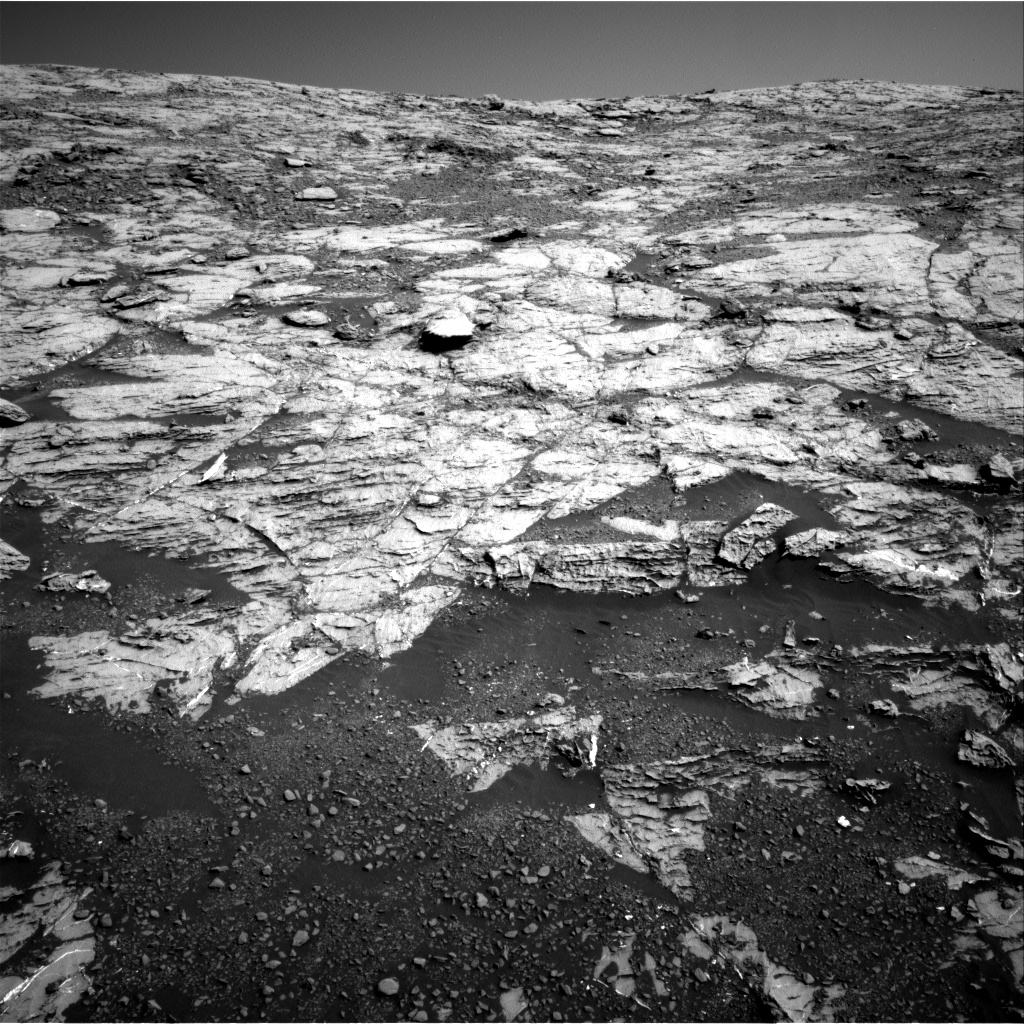
As we've seen from the past several weeks and months of imaging, Curiosity's approach to and ascent of the Vera Rubin Ridge (VRR) has provided us with stunning views of the Mount Sharp terrain. Our parking spot after this weekend's drive was no exception, seen in the Navcam image above. In today's plan we are continuing our trek up the lower strata of the VRR and have no shortage of multi-colored bedrock targets to image and analyze.

Today we planned two sols. On Sol 1814, we planned a touch-and-go (APXS analysis + full suite of MAHLI images) on the dark bedrock target "Pumpkin Nob." Additional science block activities include a corresponding ChemCam raster and Mastcam image of Pumpkin Nob. We'll also perform a multispectral Mastcam observation on "Weymouth Point," a region of VRR terrain just ahead of Curiosity. Following a drive, we'll take our standard post-drive images and DAN active observation. On Sol 1815, we have a short mid-day science block, during which ENV will conduct a suprahorizon movie and dust devil survey. ENV also has its standard REMS observations.

September 6, 2017

Sol 1809: "Thread of Life Ledge" at Elevation -4202 Meters

Written by Roger Wiens, Geochemist at Los Alamos National Laboratory

This image was taken by Navcam: Right B (NAV_RIGHT_B) onboard NASA's Mars rover Curiosity on Sol 1807 (2017-09-05 20:45:00 UTC).
Credits: NASA/JPL-Caltech
Curiosity is on the steepest part of Vera Rubin Ridge that it will encounter along its climb. The machine is performing superbly, having driven a 28 meter distance yestersol and having climbed 18 meters vertical elevation in four planning sols. The rover's current elevation is -4202 meters.

[Mars has far more extreme elevations than the continents on Earth, and it is reflected in the elevations of the landing sites to date. Curiosity landed at almost the same elevation as Viking 2 which landed in 1976 at -4.5 km. Curiosity may hopefully pass the elevation of Phoenix, which landed in 2008 at -4.14 km. The highest-elevation successful landing site to date was Opportunity, in Meridiani Planum, at -1.44 km. All elevations are measured relative to the mean planet radius.]

Curiosity now has great, unobstructed views across the lowlands of Gale crater to the rear of the rover. The view is improving as the air becomes clearer heading into the colder seasons. The first image link below shows a Navcam view into the distance past a cliff face just to the left of the rover. The image is tilted due to the to the unusually high 15.5 degree tilt of the rover as it climbs the ridge. Part of Mount Sharp is in the background. The second link shows an image looking ahead, where we see much more rock and less soil. The foreground shows that some of the pebbles are relatively well rounded. The rock face up ahead is smooth, which will mean easier driving.

Instrument activities for Sol 1809 include a DAN passive, a REMS Get Data, a RAD Get Data, a short APXS observation of "Chamberly," and four MAHLI images with stereo. ChemCam is shooting a 10-point linescan of "Chamberly" at 1.5 milliradian spacing, as well as 5-point linescans of "Locust Island Ledge" and, of all names, "Thread of Life Ledge." Mastcam is providing documentation of these targets as well as imaging "Scrag Island," "Wohoa Bay," and "Shutdown Mountain". Today's planned drive should be around 10 meters, taking the rover higher on the ridge. The second sol of activity includes a 360 degree dust devil survey with Navcam, Mastcam monitoring of the rover deck, and a new ChemCam target that will be self-selected by the AEGIS software. The rover will also image the work space around its new location.

September 5, 2017

Sols 1805-1808: No rest for the weary

Written by Michelle Minitti, Planetary Geologist at Framework

Perhaps this long Labor Day weekend, you will find yourself on a hike that ends with a particularly steep stretch. On such a steep trail, you will simply want to concentrate on reaching the top of your destination and not be required to perform any other tasks. Imagine, instead, you were asked to dribble a soccer ball, juggle and sing a show tune while making your last push up the hill. Now you know how Curiosity feels this weekend! In addition to simply driving up the 20 degree slopes on the flank of Vera Rubin Ridge, Curiosity will acquire an amazing variety of science observations of the ridge rocks.

The long list of science tasks assigned to Curiosity is directly related to the long list of geologic features surrounding the rover on this part of the ridge. The rover is now parked on many of the bedding structures observed from farther down the ridge, and the science team selected several particularly nice examples - the targets "Jordans Delight," Mount Waldo," and "Three Bush Island" - for detailed Mastcam imaging. Other features of interest were the gray, rounded nodules observed all around the rover. ChemCam will shoot a collection of these nodules embedded in the bedrock at "Toothacher Island." MAHLI and APXS will acquire images and chemistry data from a collection of loose nodules at "Gunning Rocks," followed by a Mastcam multispectral observation of the target. Mastcam will also image "Cobscook Bay," another collection of loose nodules. ChemCam will gather data from an example of the long, straight, resistant veins apparent in the bedrock in front of the rover at "Narragaugus," and keep track of the bedrock chemistry at a small vertical exposure of bedrock, "Phoebe Ledge."

ChemCam, APXS and MAHLI will uniquely analyze another bedrock target, "Robinson Rock." Both before and after ChemCam shoots the target, MAHLI will acquire tightly spaced, overlapping images of the target which will be used to build a small-scale digital elevation model (DEM) of the surface. The goal is to be able to measure the ChemCam laser pits in the DEM. Of course, the ChemCam shots will also provide chemistry of Robinson Rock complementary to the APXS analysis of the target.

Both before and after a ~27 m drive that will place Curiosity right below the smooth bedrock cap on the lower part of the Vera Rubin Ridge, she will tear her eyes off the rocks and scan the skies above Gale. At both early morning and late afternoon times, Curiosity will assess the dust load in the atmosphere, and acquire images and movies seeking dust devils and clouds. REMS, RAD and passive DAN measurements will be acquired steadily throughout the plan, and DAN will actively sense the Vera Rubin Ridge subsurface after the drive.

Someone get that rover a water bottle and some trail mix!

August 31, 2017

Sol 1802: Stereo party

Written by Rachel Kronyak, Planetary Geologist at NASA's Jet Propulsion Laboratory

Curiosity's drive on Sol 1801 brought us to an excellent location for some contact and remote science in today's 3-sol plan (setting up for a long Labor Day weekend). We'll kick off Sol 1802 with contact science (MAHLI + APXS) on the target called "Tyler," a region of Murray bedrock just in front of the rover.

We'll then enter into a very full, science-packed remote science block, during which we'll make a ChemCam LIBS observation on Tyler and take a number of Mastcam mosaics. These mosaics will look at sedimentary structures and layering within the beautifully exposed rocks of the VRR in front of us. The mosaics are fairly extensive and will document the targets named "Pettegrove Point," "Rumills Hub," "Mink Rocks," "The Downfall," and "Popplestone Ledge." The Navcam image above shows our Pettegrove Point target. As a Mastcam PUL-1 today, I was busy working with the Mastcam team and GEO group to put together our long list of imaging observations. Most of the Mastcam observations in the plan are actually stereo mosaics, which means we take each image with both the left and right eyes of Mastcam. Stereo mosaics are pretty resource intensive, but they provide us with three-dimensional depth information, which is especially useful for making geologic interpretations.

After our heavy science block, we'll perform a drive and collect our standard post-drive images to set up for contact and remote science over the weekend. We'll also do a post-drive DAN active along with our standard DAN passive and REMS observations.

August 28, 2017

Sol 1800 - 1801 Blog: Feeling the Power of Sol 1800

Written by Abigail Fraeman, Planetary Geologist at NASA's Jet Propulsion Laboratory

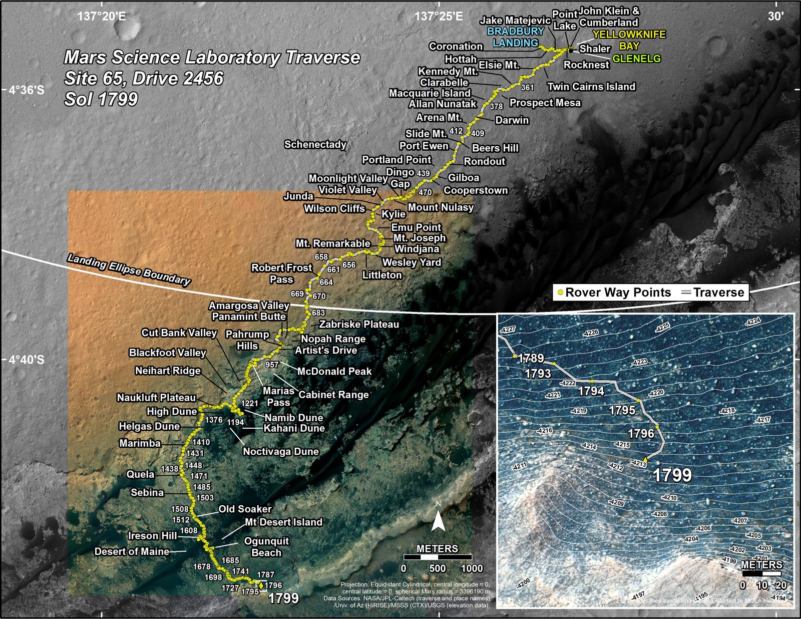
Curiosity's Traverse Map Through Sol 1799
This map shows the route driven by NASA's Mars rover Curiosity through the 1799 Martian day, or sol, of the rover's mission on Mars (August 28, 2017).
Curiosity drove 23.3 meters over the weekend, bringing us even closer to the area we will ascend Vera Rubin Ridge. We have reached the point in the traverse where we are no longer headed east along the ridge, but instead are turning to the south where orbital data show the ridge has slopes shallow enough for Curiosity to climb. We were also able to acquire some spectacular Mastcam and ChemCam RMI images of the ridge in the weekend plan, including our last "official" approach imaging mosaic! These images continue to show very interesting, fine scale sedimentary structures that hold the secrets of how the lower ridge layers were deposited.

One of the big challenges putting the plan together today was making sure the observations we wanted didn't leave the batteries too drained at the end of the plan. We keep careful track of the expected state of charge of the batteries because we want to make sure they will last a long time, and because we want to have enough power available going into the next sol's plan. Getting everything to fit inside power guidelines was challenging today in part because late autumn has come to Gale Crater. Colder temperatures mean we have to run heaters for longer, which takes more energy.

Fortunately, we were still able to figure out a way to fit many observations into the two sol plan. We'll start off on sol 1800 with some contact science, including MAHLI and APXS observations of an interesting eroded Murray formation rock target named "Bauneg Beg." Following the contact science, we'll make some ChemCam LIBS observations of targets "Bucklin Rock" and "Gilkey Harbor," and then take a 12x1 Mastcam right eye mosaic that will cover the area directly in front of the rover. Bucklin Rock looks similar to Bauneg Bag, and Gilkey Harbor is a dark, smooth rock. After our morning science, Curiosity will drive south towards Vera Rubin Ridge. After the drive on sol 1801, Curiosity will do some untargeted remote sensing, including collecting some data from the ChemCam calibration targets, and taking a Navcam suprahorizon movie, performing a dust devil search, and looking at the sun to assess the amount of dust in the atmosphere (a tau measurement).

August 28, 2017

Sol 1797-1799: Scrutinizing Vera Rubin Ridge

Written by Ryan Anderson, Planetary Geologist at USGS Astrogeology Science Center

Yesterday's drive went perfectly, putting us in a good position for a busy weekend plan. Curiosity will start off on Sol 1797 with a long (2h 45m) science block full of a variety of remote sensing. Mastcam has a multispectral observation of some gray pebbles named "Bois Bubert" followed by a routine image of the rover deck to monitor dust accumulation. Then Mastcam takes a break while ChemCam analyzes the pebbles at "Bois Bubert," some bedrock at "Doliver," some "redder"-looking bedrock at "Shag Rock," and another more typical bedrock target called "Abagadasset". ChemCam also has two long-distance RMI mosaics of "Vera Rubin Ridge" to help see the detailed sedimentary structure of the ridge. After ChemCam is done, Mastcam resumes its work, taking context images of all the ChemCam targets, and a large 44-frame mosaic of Vera Rubin Ridge. That is followed by routine atmospheric dust observations with Mastcam. But wait, there's more! That was just the first science block! Once the remote sensing is done, MAHLI and APXS will analyze the targets "Abagadasset" and "Doliver."

On Sol 1798, the morning science block is dedicated to atmospheric observations. Mastcam will repeat its atmospheric dust images, and Navcam has several observations watching for clouds. Then MAHLI will do some routine observations of the rover, checking on the health of our battered wheels, and imaging the REMS UV sensor. Finally, on Sol 1799, the rover will drive roughly 23 m and we will collect post-drive imaging so that on Monday we can see where we ended up.

I was on the downlink side of things today, so while the uplink team planned this busy weekend, I was analyzing the latest ChemCam data, including the nice RMI views of Vera Rubin Ridge. I'm looking forward to seeing all the great images that Curiosity will collect over the weekend to help us understand how the ridge formed!

August 24, 2017

Sol 1796: Elevation -4220 Meters

Written by Roger Wiens, ChemCam Principal Investigator

Curiosity completed a 30.3 meter drive yestersol, climbing another 2.4 meters in elevation. The rover is still in a soil-dominated region near the base of "Vera Rubin Ridge." The planned route takes Curiosity to the gentlest slope up the ridge. As part of that route, the rover has already climbed more than 15 meters from the elevation of the base of the ridge a little farther to the west, where the rover first approached the ridge. The highest portion of the ridge is still towering some 30 meters above the rover. Curiosity's current elevation is -4220 meters.

The SOWG meeting started with some beautiful poetry by ChemCam Science Payload Uplink Lead (sPUL) Raymond Francis about how (excitedly) distracting the recent Earth-Moon eclipse was for Mars operators, some of whom ended up doing operations remotely from eclipse sites earlier in the week. The last verse of the poem concludes:

The eclipse is no longer an imagined abstraction;
Its image remains a persistent distraction.
To see it oneself provoked wondrous reaction
That can hold us still rapt, when it's time for Mars action.

Today's Mars action plan includes an analysis by APXS on "Tinker" (bedrock immediately in front and to left of rover arm shadow in the image in the link), along with MAHLI observations of the same, a REMS UV observation, a DAN passive observation, and ChemCam targeting of "Tinker" and "Mosquick" (a darker knob on bedrock nearby). Mastcam will also image these targets (5x2, right for "Tinker", single right for "Mosquick") along with "Babbidge Ledge" (4x1 right, of bedrock slightly farther up the ridge), and follow-up imaging of the ChemCam AEGIS target from Sol 1795. A drive of ~20 meters is planned to take under an hour, with DAN active, and Navcam and Mastcam imaging from the new location to be used for the next sol's planning of observations.

August 23, 2017

Sol 1795: Skirting around Vera Rubin Ridge

Written by Lauren Edgar, Planetary Geologist at USGS Astrogeology Science Center

Curiosity is now tantalizingly close to climbing up Vera Rubin Ridge. For the past several weeks we have been skirting around the ridge, documenting sedimentary structures and bedrock composition along the way as we work toward our intended ascent route. Today's plan provided another opportunity for touch-and-go contact science, followed by a ~31 m drive. I'll be on duty later this week to help with planning the Vera Rubin Ridge campaign and acting as SOWG chair, so it was helpful to dial in to planning to prepare for my upcoming shifts.

The plan starts with MAHLI and APXS observations of the target "Agamenticus" to characterize a typical block of bedrock. ChemCam and Mastcam will also document the target, and then we'll acquire a long distance ChemCam RMI mosaic of a contact between bright and dark rocks in part of the ridge. We'll also take a Mastcam super-resolution mosaic to test its ability to bring out more detail. Mastcam will also acquire images of "Medrick Rock" and "Bibb Rock" to assess stratification and color variations. Then Curiosity will drive, and acquire post-drive imaging. The real challenge today was the limited downlink available, so the team had to think carefully about the priorities of post-drive imaging in order to prepare for tomorrow's plan. In the afternoon Curiosity will also acquire a ChemCam AEGIS target, a Mastcam tau, and a Navcam zenith movie. I'm looking forward to my upcoming shifts and the last imaging stop before we start making our way up the ridge!

August 22, 2017

Sol 1794: A Simple Plan

Written by Ryan Anderson, Planetary Geologist at USGS Astrogeology Science Center

After the excitement of a mid-planning solar eclipse yesterday, today was pretty uneventful! We had a nice long pre-drive science block which we stuffed with 2 ChemCam observations to measure the chemistry of targets "Boiler" and "Biljim" as well as a ChemCam image mosaic of the Vera Rubin Ridge. Mastcam will take pictures of each of the ChemCam targets, as well as of a knob of rock dubbed "Bombazine." Once those observations are finished, Curiosity will drive about 23 meters to place a nice patch of outcrop in the work area to be analyzed tomorrow. After the drive, we will do some post-drive imaging for targeting tomorrow, as well as a ChemCam auto-targeted observation, a dust devil survey, and an observation to watch for clouds.