NASA
NASA Science
Mars Exploration Program
Skip Navigation
menu
Images
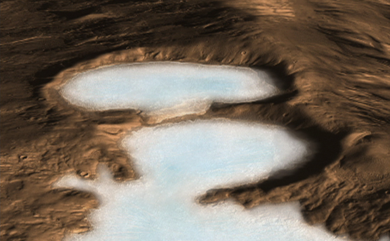
Artist concept of Glaciers on Mars
November 20, 2008
Credits
NASA/JPL-Caltech
ENLARGE
[51, 178, 188]
Related
This image acquired on January 13, 2019 by NASAs Mars Reconnaissance Orbiter, shows a cluster of dust devil tracks on the flat ground below the south polar layered deposits, but none on the layers ...
Following the Tracks
The Mars Climate Sounder instrument, shown here prior to its installation onto NASA's Mars Reconnaissance Orbiter for the mission's 2006 launch, will get a similar-looking sibling at Mars in 2016.
Climate Sounder Instrument for Mars Reconnaissance Orbiter
This view of layered rocks on the floor of McLaughlin Crater shows sedimentary rocks that contain spectroscopic evidence for minerals formed through interaction with water.
Layers with Carbonate Content Inside McLaughlin Crater on Mars
This image shows the transitional terrain where the linear troughs and rounded pits of an area called "Noctis Labyrinthus" merge with the larger canyon of "Valles Marineris." Unusual bright blocks ...
Bright and Dark Terrain in Noctis Labyrinthus (3-D)
This unnamed impact crater is about 8 kilometers in diameter and contains numerous gullies.
Bright Gully Deposits on Mars
This impact crater has gullies incised into its walls on the north and eastern sides. A couple of gullies on the north wall are unusual because a segment in the middle becomes wider than the upslop...
Gullies with Varied Shapes on a Crater Wall (3-D)
The Mars Reconnaissance Orbiter took this photo of the Curiosity rover in September 2015, as Curiosity was exploring the boundary between two rock units: the light-toned Murray Formation and the ov...
Mars Reconnaissance Orbiter Checks Curiosity's Trek
Getting a spacecraft to Mars is no walk in the park - as launch engineers are well aware. But when the spacecraft in question is among the largest ever sent to the red planet, there are specific ch...
Challenges of Getting to Mars: Heavy Lifting
Explanation on how CRISM hyperspectral images are used to understand the history and formation of Valles Marineris, one of the largest canyons in the solar system, and how the data is used to unrav...
CRISM: Exploring the Geology of Mars
This animation shows NASA's Mars Reconnaissance Orbiter flying over NASA's Curiosity (shown in pink) as the rover lands on the Red Planet. The video is slowed down as the orbiter approaches the lan...
Mars Reconnaissance Orbiter Flying Over Mars
The HiRISE camera on NASA's Mars Reconnaissance Orbiter got its best view yet of the agency's InSight lander on Sept. 23, 2019.
The Best View of InSight
This sequence of images shows a blast zone where the sky crane from NASA's Curiosity rover mission hit the ground after setting the rover down in August 2012, and how that dark scar's appearance ch...
Changes in Scars From 2012 Mars Landing
How before-and-after pictures led to the discovery of a fresh meteor impact crater on Mars.
Mars Weathercam Helps Find Big, New Crater
A view from NASA's Mars Reconnaissance Orbiter on April 8, 2015, catches sight of NASA's Curiosity Mars rover passing through a valley called "Artist's Drive" on the lower slope of Mount Sharp.
Mars Orbiter Sees Curiosity Rover in 'Artist's Drive'
This map shows the thickness of the north polar layered deposits on Mars as measured by the Shallow Radar instrument on NASA's Mars Reconnaissance Orbiter.
How Thick is the North Polar Ice Cap on Mars?
A hill with a V-shaped collapse structure, two craters and a circular fracture pattern — possibly the remains of a buried impact crater — appear to form the face of a bear on the Mars surface. This...
A Bear Lookalike on Mars
This map shows the route driven by NASA's Mars rover Curiosity through the 43rd Martian day, or sol, of the rover's mission on Mars (Sept. 19, 2012).
Curiosity Traverse Map Through Sol 43
A variety of landforms, including isolated hills, eroded mesas, dark eroded sediments, and dunes are seen within an area called "Aram Chaos."
The Eastern Floor of Aram Chaos (3-D)
This view combines information from two instruments on NASA's Mars Reconnaissance Orbiter to map color-coded composition over the shape of the ground in a small portion of the Nili Fossae plains re...
Rocks Here Sequester Some of Mars' Early Atmosphere
This image acquired on December 3, 2018 by NASAs Mars Reconnaissance Orbiter, shows a cross-section of a dune field. Dune shape depends on several factors, including the amount of sand present and ...
A First Look at Dunes
The black speck circled in the lower left corner of this image is a cluster of recently formed craters spotted on Mars using a new machine-learning algorithm. This image was taken by the Context Ca...
Machine Learning Spots a Cluster of Mars Craters: Context Camera's View
Wind is one of the most active forces shaping Mars’ surface in today’s climate. Wind-carved features such as these, called “yardangs,” are common on the Red Planet.
Wind at Work
This terrain is covered by pits and scallops (pits open on one side), perhaps due to collapse after sublimation of subsurface ice.
Utopia Planitia Scallops, Polygons, and Boulders (3-D)
This picture of a heart-shaped pit was taken on 26 February 2008 by the CTX camera aboard MRO. It is approximately 2 km long. The pit is one of many adjacent to Hydaspis Chaos, a jumbled topographi...
From the Pit of My Heart
In the novel and movie "The Martian," an astronaut's adventures take him to the rim of Mawrth Crater. This image from the HiRISE camera on NASA's Mars Reconnaissance Orbiter shows the nature of thi...
Western Edge of Mars' Marth Crater, a Movie Location
You Might Also Like
The agency established the board in May 2023 to evaluate the technical, cost, and schedule plans prior to confirmation of the mission’s design.
NASA Releases Independent Review's Mars Sample Return Report
A pair of quakes in 2021 sent seismic waves deep into the Red Planet’s core, giving scientists the best data yet on its size and composition.
NASA InSight Study Provides Clearest Look Ever at Martian Core
Ten sample tubes, capturing an amazing variety of Martian geology, have been deposited on Mars’ surface so they could be studied on Earth in the future.
NASA's Perseverance Rover Completes Mars Sample Depot
Filled with rock, the sample tube will be one of 10 forming a depot of tubes that could be considered for a journey to Earth by the Mars Sample Return campaign.
NASA's Perseverance Rover Deposits First Sample on Mars Surface
The mission has concluded that the solar-powered lander has run out of energy after more than four years on the Red Planet.
NASA Retires InSight Mars Lander Mission After Years of Science
The 10 sample tubes being dropped on Mars’ surface so they can be studied on Earth in the future carry an amazing diversity of Red Planet geology.
NASA's Perseverance Rover to Begin Building Martian Sample Depot