NASA
NASA Science
Mars Exploration Program
Skip Navigation
menu
Images
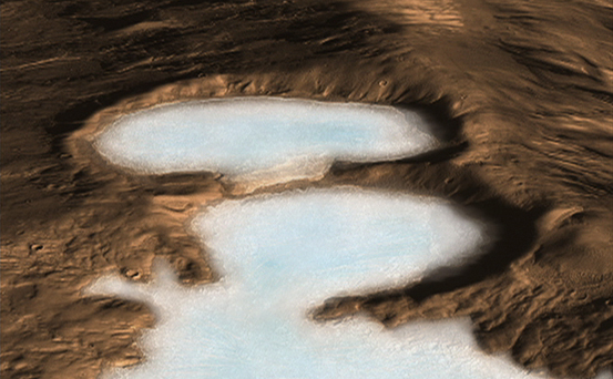
Artist concept of Glaciers on Mars
November 20, 2008
Credits
NASA/JPL-Caltech
ENLARGE
[51, 178, 188]
Related
The largest crater associated with a March 2012 impact on Mars has many smaller craters around it, revealed in this image from the High Resolution Imaging Science Experiment (HiRISE) camera on NASA...
Large, Fresh Crater Surrounded by Smaller Craters
This image acquired on September 18, 2018 by NASAs Mars Reconnaissance Orbiter, shows araneiform terrain (colloquially: spider-like terrain) located in the south polar region of Mars.
The Enduring Charm of Martian Spiders
The black speck circled in the lower left corner of this image is a cluster of recently formed craters spotted on Mars using a new machine-learning algorithm. This image was taken by the Context Ca...
Machine Learning Spots a Cluster of Mars Craters: Context Camera's View
This map shows the route driven by NASA's Curiosity Mars rover from the "Bradbury Landing" location where it landed in August 2012 (the start of the line in upper right) to a major waypoint called ...
Curiosity Mars Rover's Route from Landing to 'The Kimberley' Waypoint
NASA's Opportunity rover appears as a blip in the center of this square. This image taken by HiRISE, a high-resolution camera onboard NASA's Mars Reconnaissance Orbiter, shows the dust storm over P...
Opportunity After the Dust Storm
This image shows layered sedimentary rocks and ripples that fill and surround an impact crater in Meridiani Planum, an equatorial region where the rover Opportunity has been exploring the Martian s...
Crater in Meridiani Planum (2.3 N, 2.6 W) [3-D]
This image shows the location of the rover-containing section of new color image in relation to Solander Point.
Location of Opportunity at Solander Point
The new global mosaic, shown in a detail example at left, is stitched together from images taken by MRO’s Context Camera, which captures the Martian surface in long strips. The process is revealed ...
How the Mosaic Combines CTX Images
This image acquired on January 10, 2019 by NASAs Mars Reconnaissance Orbiter, shows large gullies on both the pole- and equator-facing slopes.
Complex Gullies in a Crater
This series of images shows carbon dioxide ice sublimating (going directly from a solid to a gas) inside a pit at Mars' south pole. Each frame of the animation was taken by the HiRISE camera on NAS...
HiRISE Spots CO2 Ice Thawing
This view of Martian surface features shaped by effects of winds was captured by the HiRISE camera on NASA's Mars Reconnaissance Orbiter on Jan. 4, 2015. The spacecraft has been orbiting Mars sinc...
Yardangs in Arsinoes Chaos, Mars
This image from the NASA Mars Reconnaissance Orbiter shows an impact scar on Mars made by pieces of the NASA Mars Science Laboratory spacecraft that the spacecraft shed just before entering the Mar...
Impact Scars from MSL Cruise Stage and Two Balance Weights (Figure 1)
This anaglyph from HiRISE shows erosional features formed by seasonal frost near the south pole of Mars.
Erosion Features near the South Pole of Mars (Anaglyph)
These dark streaks, also known as “slope streaks,” resulted from dust avalanches in an area of Mars called Acheron Fossae. The HiRISE camera aboard NASA’s Mars Reconnaissance Orbiter captured them ...
HiRISE Spots Slope Streaks on Mars in Acheron Fossae
Women working in science, technology, engineering and mathematics at NASA's Jet Propulsion Laboratory pose for a photo in mission control in honor of Women in Science Day.
Women in Science
Researchers estimating the amount of carbon held in the ground at the largest known carbonate-containing deposit on Mars utilized data from three different NASA Mars orbiters.
Multiple Instruments Used for Mars Carbon Estimate
Explanation on how CRISM hyperspectral images are used to understand the history and formation of Valles Marineris, one of the largest canyons in the solar system, and how the data is used to unrav...
CRISM: Exploring the Geology of Mars
A new map of Mars' gravity made with three NASA spacecraft is the most detailed to date, providing a revealing glimpse into the hidden interior of the Red Planet. Satellites always orbit a planet's...
Mars Gravity Map
This image (top) taken by the Shallow Radar instrument on NASA's Mars Reconnaissance Orbiter reveals the layers of ice, sand and dust that make up the north polar ice cap on Mars
What Lies Below a Martian Ice Cap
NASA's Mars Reconnaissance Orbiter, nearing the 10th anniversary of its arrival at Mars, used its High Resolution Imaging Science Experiment (HiRISE) camera to obtain this view of an area with unus...
For a Decade Orbiting Mars: One Recent View
This is the first image of Mars taken by the Context Camera on NASA's Mars Reconnaissance Orbiter.
First Context Camera Image of Mars
This map shows the frequency of carbon dioxide frost's presence at sunrise on Mars, as a percentage of days year-round. Carbon dioxide ice more often covers the ground at night in some mid-latitude...
Where on Mars Does Carbon Dioxide Frost Form Often?
Gale Crater forms a large natural repository for much of Martian geologic history.
Gale Crater's History Book
This image, taken with the High Resolution Imaging Science Experiment (HiRISE) camera, shows the transition between the "Murray Formation," in which layers are poorly expressed and difficult to tra...
Geological Transition
This nearly global mosaic of observations made by the Mars Color Imager on NASA's Mars Reconnaissance Orbiter on Nov. 18, 2012, shows a dust storm in Mars' southern hemisphere.
Martian Dust Storm, Nov. 18, 2012
You Might Also Like
The agency established the board in May 2023 to evaluate the technical, cost, and schedule plans prior to confirmation of the mission’s design.
NASA Releases Independent Review's Mars Sample Return Report
A pair of quakes in 2021 sent seismic waves deep into the Red Planet’s core, giving scientists the best data yet on its size and composition.
NASA InSight Study Provides Clearest Look Ever at Martian Core
Ten sample tubes, capturing an amazing variety of Martian geology, have been deposited on Mars’ surface so they could be studied on Earth in the future.
NASA's Perseverance Rover Completes Mars Sample Depot
Filled with rock, the sample tube will be one of 10 forming a depot of tubes that could be considered for a journey to Earth by the Mars Sample Return campaign.
NASA's Perseverance Rover Deposits First Sample on Mars Surface
The mission has concluded that the solar-powered lander has run out of energy after more than four years on the Red Planet.
NASA Retires InSight Mars Lander Mission After Years of Science
The 10 sample tubes being dropped on Mars’ surface so they can be studied on Earth in the future carry an amazing diversity of Red Planet geology.
NASA's Perseverance Rover to Begin Building Martian Sample Depot