NASA
NASA Science
Mars Exploration Program
Skip Navigation
menu
Images
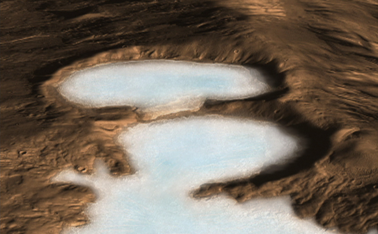
Artist concept of Glaciers on Mars
November 20, 2008
Credits
NASA/JPL-Caltech
ENLARGE
[51, 178, 188]
Related
The long, sinuous raised ridges on this fan of material are thought to be inverted stream channels. These ridges may have been low-lying streambeds that hardened and then turned into ridges when th...
Fan in the Aeolis Region (3-D)
This image acquired on December 13, 2020 by NASAs Mars Reconnaissance Orbiter, shows blobby features in the polar cap that are due to the sun sublimating away the carbon dioxide into these round pa...
Changes of a Happy Crater
This graphic maps locations of the sites where NASA's Curiosity Mars rover collected its first 19 rock or soil samples for laboratory analysis inside the vehicle. It also presents images of the dri...
Curiosity's Rock or Soil Sampling Sites on Mars, Through November 2016
This graph shows a spectrum recorded by the Chemistry and Camera instrument (ChemCam) in NASA's Curiosity Mars rover.
ChemCam Spectrum from Martian Rock Target 'Ithaca'
Impact cratering and erosion combine to reveal the composition of the Martian underground by exposing materials from the subsurface.
Clay Minerals in Craters and Escarpments on Mars (Figure 4)
A comparison of two radargrams from the SHARAD instrument on NASA's Mars Reconnaissance Orbiter shows effects on the Martian ionosphere from the close passage of a comet.
Radar Indication of Effect of Comet Flyby on Martian Ionosphere
The Mars Reconnaissance Orbiter’s Context Camera, which captured the 110,000 images that make up the interactive global mosaic, is especially useful for spotting impact craters like those seen here.
Global CTX Mosaic of Mars: Impact Craters
This animation demonstrates the salty ponds and streams that scientists think may have been left behind as Gale Crater dried out over time. The bottom of the image is the floor of Gale Crater, with...
Sutton Island Model of Drying Lakes
Impact cratering and erosion combine to reveal the composition of the Martian underground by exposing materials from the subsurface.
Clay Minerals in Craters and Escarpments on Mars (Figure 1)
Shalbatana Vallis is a large channel with steep walls and a flat floor that may have formed by water draining from nearby Ganges Chasma. Here a section of the wall collapsed and produced a landslid...
Landslide in Shalbatana Vallis (3-D)
The South Polar residual cap (the part that lasts through the summer) is composed of carbon dioxide ice.
Honey, I Shrunk the Mesas
About 1000 Viking Orbiter red- and violet-filter images have been processed to provide global color coverage of Mars at a scale of 1 km/pixel.
Global Color Views of Mars
This "ring trough" or eroded pit crater, is located in the rugged southern highland terrain known as Noachis Terra. The HiRISE image shows the layered, boulder-rich wall rock facing to the northeas...
Gullies on Southwest Slope of Ring Trough in Noachis Terra
The Mars Color Imager (MARCI), shown here with a gloved hand for scale, is designed to produce a global map to help characterize daily, seasonal and year-to-year variations in Mars' climate, provid...
Mars Color Imager (MARCI) for Mars Reconnaissance Orbiter
This nearly global mosaic of observations made by the Mars Color Imager on NASA's Mars Reconnaissance Orbiter on Nov. 18, 2012, shows a dust storm in Mars' southern hemisphere.
Martian Dust Storm, Nov. 18, 2012
This image contrasts gullies and recurring warm-season slope flows appearing in the same crater, in the middle southern latitudes of Mars.
Gullies and Newly Identified Flow Features in Same Mars Crater
What is this enigmatic landform?
An Enigmatic Feature in Athabasca Lava Flows
Terrain in Vastitas Borealis Region.
Terrain in Vastitas Borealis Region
This map shows the route driven by NASA's Curiosity Mars rover from the location where it landed in August 2012 to its location in December 2015, at examples of the Bagnold Dunes.
Curiosity Rover's Traverse, First 1,185 Sols on Mars
Artist rendering of commercial Mars satellites providing communications back to Earth.
Artist's Concept of Mars Satellites
Image of Hesperia Planum from the HiRISE camera on Mars Reconnaissance Orbiter.
Hesperia Planum
This sequence of images shows a blast zone where the sky crane from NASA's Curiosity rover mission hit the ground after setting the rover down in August 2012, and how that dark scar's appearance ch...
Changes in Scars From 2012 Mars Landing
The High Resolution Imaging Science Experiment (HiRISE) camera on NASA's Mars Reconnaissance Orbiter caught this view of NASA's Mars Exploration Rover Opportunity on Feb. 14, 2014.
Opportunity Rover on 'Murray Ridge' Seen From Orbit (Annotated)
Mars Reconnaissance Orbiter Project Manager Jim Graf hugs Jet Propulsion Laboratory Director Dr. Charles Elachi after a successful orbit insertion on March 10, 2006.
Mars Reconnaissance Orbiter Mission Team Members Celebrate Orbit Insertion Success
Stages in the seasonal disappearance of surface ice from the ground around the Phoenix Mars Lander are visible in these images taken on Feb. 8, 2010, (left) and Feb. 25, 2010, during springtime on ...
Ice Around Phoenix Lander Continues to Lessen in Spring
You Might Also Like
The agency established the board in May 2023 to evaluate the technical, cost, and schedule plans prior to confirmation of the mission’s design.
NASA Releases Independent Review's Mars Sample Return Report
A pair of quakes in 2021 sent seismic waves deep into the Red Planet’s core, giving scientists the best data yet on its size and composition.
NASA InSight Study Provides Clearest Look Ever at Martian Core
Ten sample tubes, capturing an amazing variety of Martian geology, have been deposited on Mars’ surface so they could be studied on Earth in the future.
NASA's Perseverance Rover Completes Mars Sample Depot
Filled with rock, the sample tube will be one of 10 forming a depot of tubes that could be considered for a journey to Earth by the Mars Sample Return campaign.
NASA's Perseverance Rover Deposits First Sample on Mars Surface
The mission has concluded that the solar-powered lander has run out of energy after more than four years on the Red Planet.
NASA Retires InSight Mars Lander Mission After Years of Science
The 10 sample tubes being dropped on Mars’ surface so they can be studied on Earth in the future carry an amazing diversity of Red Planet geology.
NASA's Perseverance Rover to Begin Building Martian Sample Depot