NASA
NASA Science
Mars Exploration Program
Skip Navigation
menu
Images
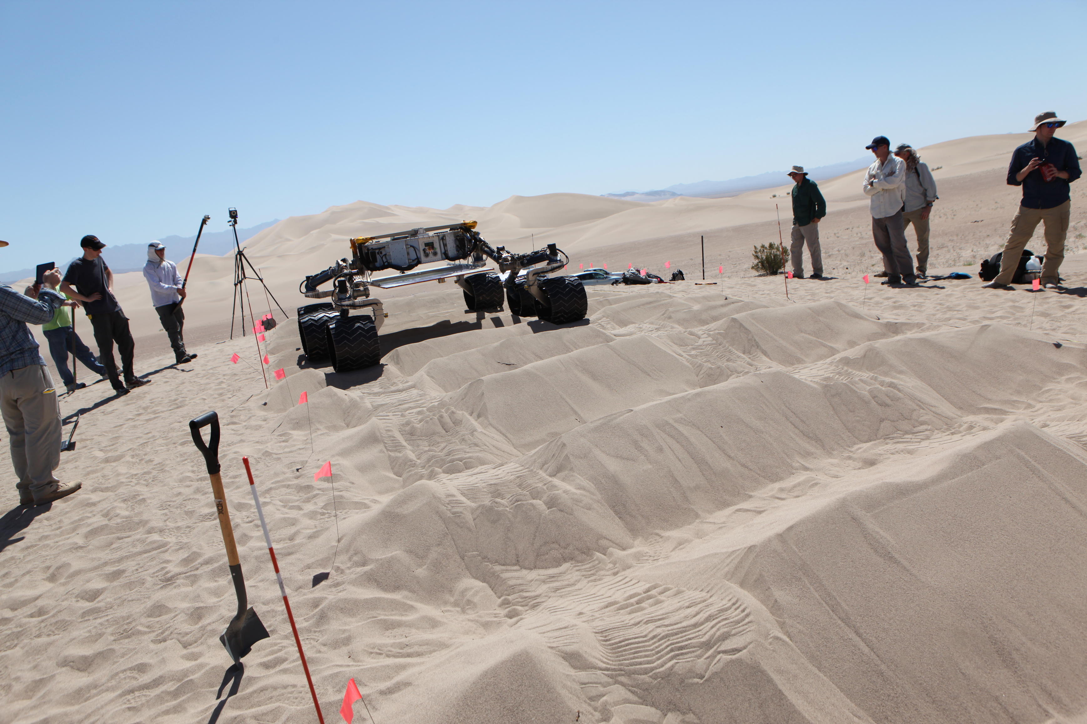
Driving Over Sandy Ripples
June 05, 2014
Credits
NASA/JPL-Caltech
ENLARGE
[51, 176]
Related
This image from the right Mast Camera (Mastcam) of NASA's Curiosity Mars rover shows roughly spherical features.
Spherules in 'Yellowknife Bay' (Unannotated)
Parachute Opening During Tests for Mars Science Laboratory
Parachute Opening During Tests for Mars Science Laboratory
This view from the Mastcam on NASA's Curiosity Mars rover shows dramatic buttes and layers on the lower flank of Mount Sharp. It was taken on Sept. 7, 2013, from near the waypoint called "Darwin" o...
Mount Sharp Buttes and Layers From Near 'Darwin'
A group watching motions of an engineering model of the camera mast for NASA's Mars rover Curiosity on March 5, 2010, includes moviemaker James Cameron (right).
Moviemaker with Mars Rover 'Stunt Double'
NASA's Curiosity rover delivers its first soil sample to its chemistry and mineralogy instrument.
Mars Soil Sample Delivered
About the size of a small SUV, NASA's Curiosity rover is well equipped for a tour of Gale Crater on Mars.
NASA's Curiosity Rover in Profile
NASA's Curiosity Mars rover recorded this sequence of views of the sun setting at the close of the mission's 956th Martian day, or sol (April 15, 2015), from the rover's location in Gale Crater.
Sunset Sequence in Mars' Gale Crater
Engineers just installed six new wheels on the Curiosity rover, and rotated all six wheels at once on July 9, 2010.
Curiosity Spins Its Wheels
This 360-degree panorama shows the "Marias Pass" area, at center, and part of the slope that NASA's Curiosity Mars rover climbed to get there, at right.
Full-Circle View Near 'Marias Pass' on Mars
This view southeastward from Curiosity's Mast Camera (Mastcam) shows terrain judged difficult for traversing between the rover and an outcrop in the middle distance where a pale rock unit meets a d...
Unfavorable Terrain for Crossing Near 'Logan Pass' (Figure 1: Labeled)
After a rocket-powered descent stage, also known as the sky crane, delivered NASA's Curiosity rover to Mars on Aug. 5 PDT (Aug. 6 EDT), 2012, it flew away and fell to the surface.
Dissecting the Scene of Sky Crane Crash
A conventional X-ray diffraction instrument (left) is the size of a large refrigerator, in contrast to the compact size of the Chemistry and Mineralogy (CheMin) instrument on NASA's Curiosity rover...
X-ray Diffraction, Big and Small
This view from the left Navigation Camera (Navcam) of NASA's Mars Rover Curiosity looks back at wheel tracks made during the first drive away from the last science target in the "Glenelg" area.
First Leg of Long Trek Toward Mount Sharp
This image show the body of the Mars Science Laboratory rover with the tubes from the rover's 'radiator' system on the outsideand inside of the body.
Keeping It Cool (...or Warm)
A swept Martian rock called "Bonanza King" can be seen in this image take by NASA's Mars Curiosity rover.
A Bonanza of Clues About Mars
This view of the lower front and underbelly areas of NASA's Mars rover Curiosity combines nine images taken by the rover's Mars Hand Lens Imager (MAHLI) during the 34th Martian day, or sol, of Cur...
Panorama of Curiosity's Belly Check
A selfie taken by NASA's Curiosity Mars rover on Sol 2291 (January 15) at the "Rock Hall" drill site, located on Vera Rubin Ridge.
Curiosity's Selfie at "Rock Hall"
This engineering animation depicts the moves that NASA's rover Curiosity made on Sept. 22, 2012, when the rover touched a Martian rock with its robotic arm for the first time. Curiosity examined th...
First Rock Contact by Curiosity's Arm
A shiny-looking Martian rock is visible in this image taken by NASA's Mars rover Curiosity's Mast Camera (Mastcam) during the mission's 173rd Martian day, or sol (Jan. 30, 2013).
Shiny-Looking Martian Rock
How samples are delivered and then tested in the Sample Analysis at Mars (SAM) suite on the Mars Curiosity rover. (No audio)
Sample Analysis at Mars (SAM) suite on Mars Curiosity
Scientists get closer to selecting a landing site for the Curiosity rover.
Challenges of Getting to Mars: Selecting a Landing Site
This image from the Mast Camera (Mastcam) on NASA's Mars rover Curiosity shows inclined layering known as cross-bedding in an outcrop called "Shaler" on a scale of a few tenths of meters, or decime...
'Shaler' Unit's Evidence of Stream Flow (Unannotated)
The Sample Analysis at Mars instrument suite will weigh about 83 pounds (38 kilograms) and make up about half the science payload of the Mars Science Laboratory mission. It is a suite of three inst...
Sample Analysis at Mars
This artist's concept animation depicts key events in NASA's Mars Science Laboratory mission, including launch; cruise; entry, descent & landing; and, surface operations.
Mars Science Laboratory (Curiosity Rover) Mission Animation
Filled with briny lakes, the Quisquiro salt flat in South America's Altiplano represents the kind of landscape that scientists think may have existed in Gale Crater, which NASA's Curiosity rover is...
South America's Altiplano Looks Like Mars
You Might Also Like
The agency established the board in May 2023 to evaluate the technical, cost, and schedule plans prior to confirmation of the mission’s design.
NASA Releases Independent Review's Mars Sample Return Report
A pair of quakes in 2021 sent seismic waves deep into the Red Planet’s core, giving scientists the best data yet on its size and composition.
NASA InSight Study Provides Clearest Look Ever at Martian Core
Ten sample tubes, capturing an amazing variety of Martian geology, have been deposited on Mars’ surface so they could be studied on Earth in the future.
NASA's Perseverance Rover Completes Mars Sample Depot
Filled with rock, the sample tube will be one of 10 forming a depot of tubes that could be considered for a journey to Earth by the Mars Sample Return campaign.
NASA's Perseverance Rover Deposits First Sample on Mars Surface
The mission has concluded that the solar-powered lander has run out of energy after more than four years on the Red Planet.
NASA Retires InSight Mars Lander Mission After Years of Science
The 10 sample tubes being dropped on Mars’ surface so they can be studied on Earth in the future carry an amazing diversity of Red Planet geology.
NASA's Perseverance Rover to Begin Building Martian Sample Depot