NASA
NASA Science
Mars Exploration Program
Skip Navigation
menu
Images
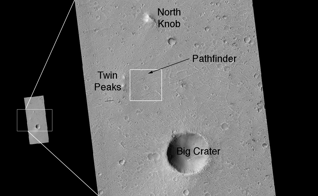
Landing Site Region
January 11, 2007
Credits
NASA/JPL/Univ. of Arizona
ENLARGE
[51, 178]
Related
This map shows the thickness of the north polar layered deposits on Mars as measured by the Shallow Radar instrument on NASA's Mars Reconnaissance Orbiter.
How Thick is the North Polar Ice Cap on Mars?
This image shows a cross-section of a portion of the north polar ice cap of Mars, derived from data acquired by the Mars Reconnaissance Orbiter's Shallow Radar (SHARAD), one of six instruments on t...
North Polar Cap Cross Section
This map shows the path on Mars of NASA's Curiosity rover toward Glenelg, an area where three terrains of scientific interest converge.
Curiosity's Roadside Discoveries
These images from the Context Camera on NASA's Mars Reconnaissance Orbiter were taken before and after an apparent impact scar appeared in the area in March 2012. Comparing the Jan. 16, 2012, image...
Before-and-After Views Confirm Fresh Craters
The bright feature in this image might be the parachute from a 1971 Soviet Mars lander named Mars 3. The image was taken by the High Resolution Imaging Science Experiment (HiRISE) camera on NASA's...
Possible Parachute From 1971 Soviet Mars Lander
This image shows an example of layers in the Martian north polar deposits. These deposits, part of the Planum Boreum dome, are composed mainly of water ice and small amounts of dust.
Stratigraphy of the North Polar Deposits
This terrain is covered by pits and scallops (pits open on one side), perhaps due to collapse after sublimation of subsurface ice.
Utopia Planitia Scallops, Polygons, and Boulders (3-D)
This image from NASA's Mars Reconnaissance Orbiter shows a hill with a central crater. Such features have been interpreted as both mud volcanoes (really a sedimentary structure) and as actual volca...
A Volcano of Mud or Lava?
Is frozen carbon dioxide a key to features in some Martian gullies? To find out, scientists grabbed a bag of dry ice and took a road trip.
Dry Ice Moves on Mars
Wrinkle Ridge in Solis Planum
Wrinkle Ridge in Solis Planum
As the Sun peeks above the horizon at the Martian south polar icecap, powerful jets of carbon-dioxide (CO2) gas erupt through the icecap's topmost layer.
Dry Ice Spiders on Mars
This map shows five locations where fresh impact cratering has excavated water ice from just beneath the surface of Mars (sites 1 through 5) and the Viking Lander 2 landing site (VL2), in the conte...
Expected Depths to Ice, Mid-Latitude Northern Mars
The High Resolution Imaging Science Experiment (HiRISE) camera on NASA's Mars Reconnaissance Orbiter snapped this series of false-color pictures of sand dunes in the north polar region of Mars
Seasonal Changes on Far-Northern Mars
This image acquired on December 8, 2018 by NASAs Mars Reconnaissance Orbiter, shows erosion of the surface revealing several shades of light toned layers, likely sedimentary deposits.
Layered History
This image acquired on January 21, 2019 by NASAs Mars Reconnaissance Orbiter, shows the south polar layered deposits are well illuminated to accentuate the topography.
Everything is (Well) Illuminated
Eberswalde Crater was one of the four final landing sites considered for the MSL rover. A channel leads into the crater and the lithified remains of a delta, a fan-like feature formed when sediment...
Eberswalde Delta (3-D)
A towering dust devil casts a serpentine shadow over the Martian surface in this image acquired by the High Resolution Imaging Science Experiment (HiRISE) camera on NASA's Mars Reconnaissance Orbiter.
The Serpent Dust Devil of Mars
A large dust storm on Mars, nearly twice the size of the United States, covered the southern hemisphere of the Red Planet in early January 2022, leading to some of NASA’s explorers on the surface h...
Mars Report: Dust Storms on Mars
This proposed future Mars landing site in Acidalia Planitia targets densely occurring mounds thought to be mud volcanoes.
Proposed Future Mars Landing Site: Acidalia Planitia Mud Volcanoes
NASA's Mars rover Curiosity left the "Glenelg" area on July 4, 2013, on a "rapid transit route" to the entry point for the mission's next major destination, the lower layers of Mount Sharp.
Curiosity's Progress on Route from 'Glenelg' to Mount Sharp
The large impact crater known as Stickney is the largest crater on the Martian moon Phobos.
Stickney Crater, Phobos
This image is located within Northern Sinus Meridiani, a region of ridged terrains and extensive stratigraphic layering.
Crater with Surrounding Bench in Sinus Meridiani (3-D)
This global map of Mars was acquired on July 31, 2012, by the Mars Color Imager instrument on NASA's Mars Reconnaissance Orbiter.
Mars Weather Map, July 31
NASA's Mars Reconnaissance Orbiter has clocked more than a decade of service at the Red Planet and has yielded scientific discoveries and magnificent views of a distant world. These images taken by...
Magnificent Mars: 10 Years of Mars Reconnaissance Orbiter
This image covers a "fresh-looking" impact crater with a diameter of about 2 kilometers (1.2 miles).
Many Gullies in a Fresh Impact Crater (3-D)
You Might Also Like
The agency established the board in May 2023 to evaluate the technical, cost, and schedule plans prior to confirmation of the mission’s design.
NASA Releases Independent Review's Mars Sample Return Report
A pair of quakes in 2021 sent seismic waves deep into the Red Planet’s core, giving scientists the best data yet on its size and composition.
NASA InSight Study Provides Clearest Look Ever at Martian Core
Ten sample tubes, capturing an amazing variety of Martian geology, have been deposited on Mars’ surface so they could be studied on Earth in the future.
NASA's Perseverance Rover Completes Mars Sample Depot
Filled with rock, the sample tube will be one of 10 forming a depot of tubes that could be considered for a journey to Earth by the Mars Sample Return campaign.
NASA's Perseverance Rover Deposits First Sample on Mars Surface
The mission has concluded that the solar-powered lander has run out of energy after more than four years on the Red Planet.
NASA Retires InSight Mars Lander Mission After Years of Science
The 10 sample tubes being dropped on Mars’ surface so they can be studied on Earth in the future carry an amazing diversity of Red Planet geology.
NASA's Perseverance Rover to Begin Building Martian Sample Depot