NASA
NASA Science
Mars Exploration Program
Skip Navigation
menu
Images
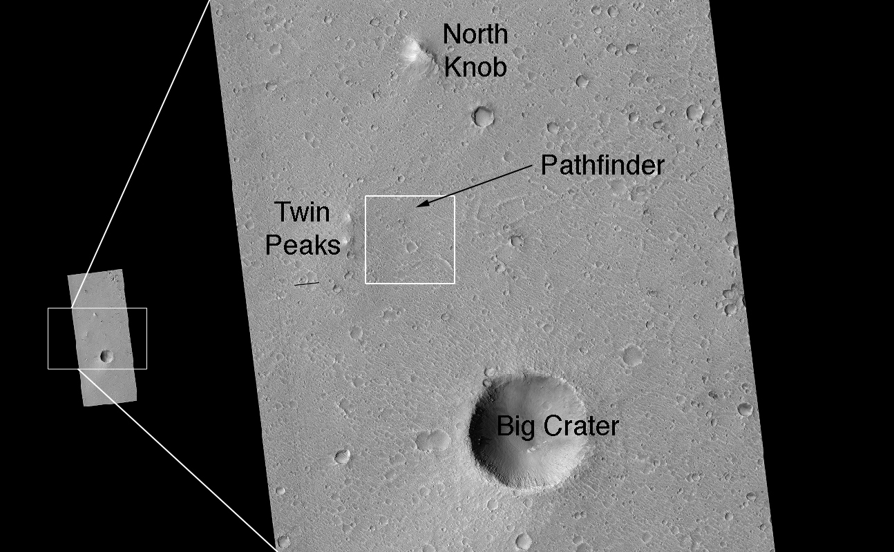
Landing Site Region
January 11, 2007
Credits
NASA/JPL/Univ. of Arizona
ENLARGE
[51, 178]
Related
NASA's Mars Exploration Rover Opportunity has been working on Mars since landing inside Eagle Crater on Jan. 25, 2004 (Universal Time; evening of Jan. 24, Pacific Standard Time).
Opportunity's First Decade of Driving on Mars
This map shows the thickness of the north polar layered deposits on Mars as measured by the Shallow Radar instrument on NASA's Mars Reconnaissance Orbiter.
How Thick is the North Polar Ice Cap on Mars?
This map shows the route driven by NASA's Curiosity Mars rover from the location where it landed in August 2012 to its location in December 2015, at examples of the Bagnold Dunes.
Curiosity Rover's Traverse, First 1,185 Sols on Mars
This rainbow-colored map shows underground water ice on Mars. Cool colors are closer to the surface than warm colors; black zones indicate areas where a spacecraft would sink into fine dust; the ou...
A Water Ice Map for Mars
Crater in Thaumasia Fossae
Crater in Thaumasia Fossae
In this HiRISE image taken within Capri Chasma, TES also detected the same crystalline gray hematite like that found at Meridiani Planum.
Hematite in Capri Chasma
This image is located within Northern Sinus Meridiani, a region of ridged terrains and extensive stratigraphic layering.
Layered Yardangs (3-D)
What is this enigmatic landform?
An Enigmatic Feature in Athabasca Lava Flows
This image acquired on October 28, 2018 by NASAs Mars Reconnaissance Orbiter, shows that gullies probably formed along the bouldery layers in the upper slopes of this unnamed crater.
Multi-Elevation Gullies
This image acquired on December 13, 2020 by NASAs Mars Reconnaissance Orbiter, shows blobby features in the polar cap that are due to the sun sublimating away the carbon dioxide into these round pa...
Changes of a Happy Crater
More evidence of a dynamic Mars is revealed at the edge of a martian dune field.
Active High-Latitude Dune Gullies
This image, taken by HiRISE, shows a lobate tongue on the Northwest Hellas rim.
Lobate Flow Features in the Northwest Hellas Rim (3-D)
The largest crater in this mosaic of images taken by the Context Camera on NASA's Mars Reconnaissance Orbiter is Endeavour Crater, which is 22 kilometers (14 miles) in diameter.
Endeavour Crater in Context
This view of layered rocks on the floor of McLaughlin Crater shows sedimentary rocks that contain spectroscopic evidence for minerals formed through interaction with water.
Layers with Carbonate Content Inside McLaughlin Crater on Mars (Annotated Figure 1)
This 3D, or stereo anaglyph, view shows the parachute and back shell that helped guide NASA's Curiosity to the surface of Mars. The view was produced from images taken by the High Resolution Imagin...
Parachute and Back Shell in 3-D
Wind is one of the most active forces shaping Mars’ surface in today’s climate. Wind-carved features such as these, called “yardangs,” are common on the Red Planet.
Wind at Work
The Cerberus Fossae are a group of troughs in the Cerberus region of Mars that run roughly parallel to one another. They formed due to extension of the crust in the region. Some of the troughs, suc...
Vent in the Cerberus Region (3-D)
Intra-Crater Structure in NW Hellas Basin, Mars
Intra-Crater Structure in NW Hellas Basin, Mars
This image provides higher-resolution views of a site where another observation (PIA10247) indicates the presence of chloride salt deposits.
Bright Exposures of Chloride Salt on Southern Mars
With its cracked, blistery appearance, this mound near the center of a very large, over 5-kilometer diameter mid-latitude crater poses an interesting question: how did this form?
An Unusual Mound
A portion of a trough in the Nili Fossae region of Mars is shown in enhanced color in this image from the High Resolution Imaging Science Experiment (HiRISE) camera on NASA's Mars Reconnaissance Or...
Color Image of Layers in Holden Crater, a Candidate MSL Landing Site
Shown in this image from NASA's Mars Reconnaissance Orbiter are fan-shaped deposits emerging from regions of steep topography called alluvial fans. Alluvial fans on Mars are thought to be ancient a...
The Case of the Martian Boulder Piles
This map shows the footprints of images taken by the HiRISE camera on NASA's Mars Reconnaissance Orbiter as part of advance analysis of the area where NASA's InSight mission will land in 2018. The ...
Advance Inspection of NASA's Next Mars Landing Site
Mars' north polar deposits comprise a thick stack of icy layers. Part of this image from NASA's Mars Reconnaissance Orbiter (MRO) has lingering seasonal frost, which serves to accentuate those laye...
Lingering Frost
These color-enhanced views of Deimos, the smaller of the two moons of Mars, were taken by the High Resolution Imaging Science Experiment (HiRISE) camera on NASA's Mars Reconnaissance Orbiter.
Martian Moon Deimos in High Resolution
You Might Also Like
The agency established the board in May 2023 to evaluate the technical, cost, and schedule plans prior to confirmation of the mission’s design.
NASA Releases Independent Review's Mars Sample Return Report
A pair of quakes in 2021 sent seismic waves deep into the Red Planet’s core, giving scientists the best data yet on its size and composition.
NASA InSight Study Provides Clearest Look Ever at Martian Core
Ten sample tubes, capturing an amazing variety of Martian geology, have been deposited on Mars’ surface so they could be studied on Earth in the future.
NASA's Perseverance Rover Completes Mars Sample Depot
Filled with rock, the sample tube will be one of 10 forming a depot of tubes that could be considered for a journey to Earth by the Mars Sample Return campaign.
NASA's Perseverance Rover Deposits First Sample on Mars Surface
The mission has concluded that the solar-powered lander has run out of energy after more than four years on the Red Planet.
NASA Retires InSight Mars Lander Mission After Years of Science
The 10 sample tubes being dropped on Mars’ surface so they can be studied on Earth in the future carry an amazing diversity of Red Planet geology.
NASA's Perseverance Rover to Begin Building Martian Sample Depot