NASA
NASA Science
Mars Exploration Program
Skip Navigation
menu
Images
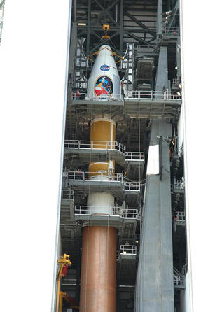
Countdown Nears: Final Tests
July 14, 2009
Credits
NASA
ENLARGE
[51, 178]
Related
'Marsshine' on Shadowed Part of Phobos
Phobos from 5,800 Kilometers
These dark streaks, also known as “slope streaks,” resulted from dust avalanches in an area of Mars called Acheron Fossae. The HiRISE camera aboard NASA’s Mars Reconnaissance Orbiter captured them ...
HiRISE Spots Slope Streaks on Mars in Acheron Fossae
This image is an artist's concept of a view looking down on NASA's Mars Reconnaissance Orbiter. The spacecraft is pictured using its Shallow Subsurface Radar instrument (SHARAD) to "look" under the...
Mars Reconnaissance Orbiter's Radar, Top View (Artist's Concept)
On Mars the seasonal polar caps are composed of dry ice (carbon dioxide). In the springtime as the sun shines on the ice, it turns from solid to gas and causes erosion of the surface
Dry Ice Gone Wild
This image shows a cross-section of a portion of the north polar ice cap of Mars, derived from data acquired by the Mars Reconnaissance Orbiter's Shallow Radar (SHARAD), one of six instruments on t...
North Polar Cap Cross Section (Annotated)
This image acquired on September 18, 2018 by NASAs Mars Reconnaissance Orbiter, shows araneiform terrain (colloquially: spider-like terrain) located in the south polar region of Mars.
The Enduring Charm of Martian Spiders
This image shows lava crumpled against the upstream side of an impact crater.
Lava Against an Impact Crater in Elysium Planitia
This 3D, or stereo anaglyph, view shows the upcoming science destination for NASA's Mars rover Curiosity, a region dubbed "Glenelg," where three different types of material seen from orbit come tog...
'Glenelg' in 3D
This graphic maps locations of the sites where NASA's Curiosity Mars rover collected its first 19 rock or soil samples for laboratory analysis inside the vehicle. It also presents images of the dri...
Curiosity's Rock or Soil Sampling Sites on Mars, Through November 2016
This close-up image of a dust storm on Mars was acquired by the Mars Color Imager instrument on NASA's Mars Reconnaissance Orbiter on Nov. 7, 2007.
Martian Dust Storm
This picture of a heart-shaped pit was taken on 26 February 2008 by the CTX camera aboard MRO. It is approximately 2 km long. The pit is one of many adjacent to Hydaspis Chaos, a jumbled topographi...
From the Pit of My Heart
This near-global map was captured by NASA’s Mars Reconnaissance Orbiter using its Compact Reconnaissance Imaging Spectrometer for Mars, or CRISM. The yellow square indicates the Nili Fossae region ...
One of CRISM's Final Maps of Mars
This image, taken with the High Resolution Imaging Science Experiment (HiRISE) camera, shows the transition between the "Murray Formation," in which layers are poorly expressed and difficult to tra...
Geological Transition
The bright linear features cutting the bedrock in the center region of this image look like mineral veins.
Mineral Veins (3-D)
This graphic depicts the relative shapes and distances from Mars for five active orbiter missions plus the planet's two natural satellites. It illustrates the potential for intersections of the spa...
Diverse Orbits Around Mars
Northern Hemisphere Gullies on West-Facing Crater Slope, Mars
Northern Hemisphere Gullies on West-Facing Crater Slope, Mars
Interact with this 3D model of the Mars Reconnaissance Orbiter.
Mars Reconnaissance Orbiter, 3D Model
The largest crater in this mosaic of images taken by the Context Camera on NASA's Mars Reconnaissance Orbiter is Endeavour Crater, which is 22 kilometers (14 miles) in diameter.
Endeavour Crater in Context
Dust-Mantled Topography near Zephyria Tholus
Dust-Mantled Topography near Zephyria Tholus
The Mars Reconnaissance Orbiter has seen many places on the planet. One of the most interesting is one of the great canyon systems on Mars.
Soaring Over Mars
This cross-section view of underground layers near Mars' south pole is a radargram based on data from the Shallow Subsurface Radar (SHARAD) instrument on NASA's Mars Reconnaissance Orbiter
Cross Section of Buried Carbon-Dioxide Ice on Mars
These long, smooth features are sand ridges shaped by the constant martian wind. They run perpendicular, or at right angles to, the direction of the wind and often found in channels and crater inte...
MRO Spots Sand Stripes
This map shows five locations where fresh impact cratering has excavated water ice from just beneath the surface of Mars (sites 1 through 5) and the Viking Lander 2 landing site (VL2), in the conte...
Expected Depths to Ice, Mid-Latitude Northern Mars
This view shows the ground covered in the first image of Mars taken by the High Resolution Imaging Science Experiment camera (HiRISE) on NASA's Mars Reconnaissance Orbiter
First Mars Image from Newly Arrived Camera
This mosaic, taken with the High Resolution Imaging Science Experiment (HiRISE) camera on NASA's Mars Reconnaissance Orbiter, shows the planned route (in yellow) of NASA's Curiosity rover from "Pah...
Curiosity Rover Planned Route
You Might Also Like
The agency established the board in May 2023 to evaluate the technical, cost, and schedule plans prior to confirmation of the mission’s design.
NASA Releases Independent Review's Mars Sample Return Report
A pair of quakes in 2021 sent seismic waves deep into the Red Planet’s core, giving scientists the best data yet on its size and composition.
NASA InSight Study Provides Clearest Look Ever at Martian Core
Ten sample tubes, capturing an amazing variety of Martian geology, have been deposited on Mars’ surface so they could be studied on Earth in the future.
NASA's Perseverance Rover Completes Mars Sample Depot
Filled with rock, the sample tube will be one of 10 forming a depot of tubes that could be considered for a journey to Earth by the Mars Sample Return campaign.
NASA's Perseverance Rover Deposits First Sample on Mars Surface
The mission has concluded that the solar-powered lander has run out of energy after more than four years on the Red Planet.
NASA Retires InSight Mars Lander Mission After Years of Science
The 10 sample tubes being dropped on Mars’ surface so they can be studied on Earth in the future carry an amazing diversity of Red Planet geology.
NASA's Perseverance Rover to Begin Building Martian Sample Depot