July 22, 2019

Sol 2472-2473: Additional Contact Science and a Soliday at Sandside Harbour

Written by Lauren Edgar, Planetary Geologist at USGS Astrogeology Science Center
Sol 2472-2473: Additional Contact Science and a Soliday at Sandside Harbour

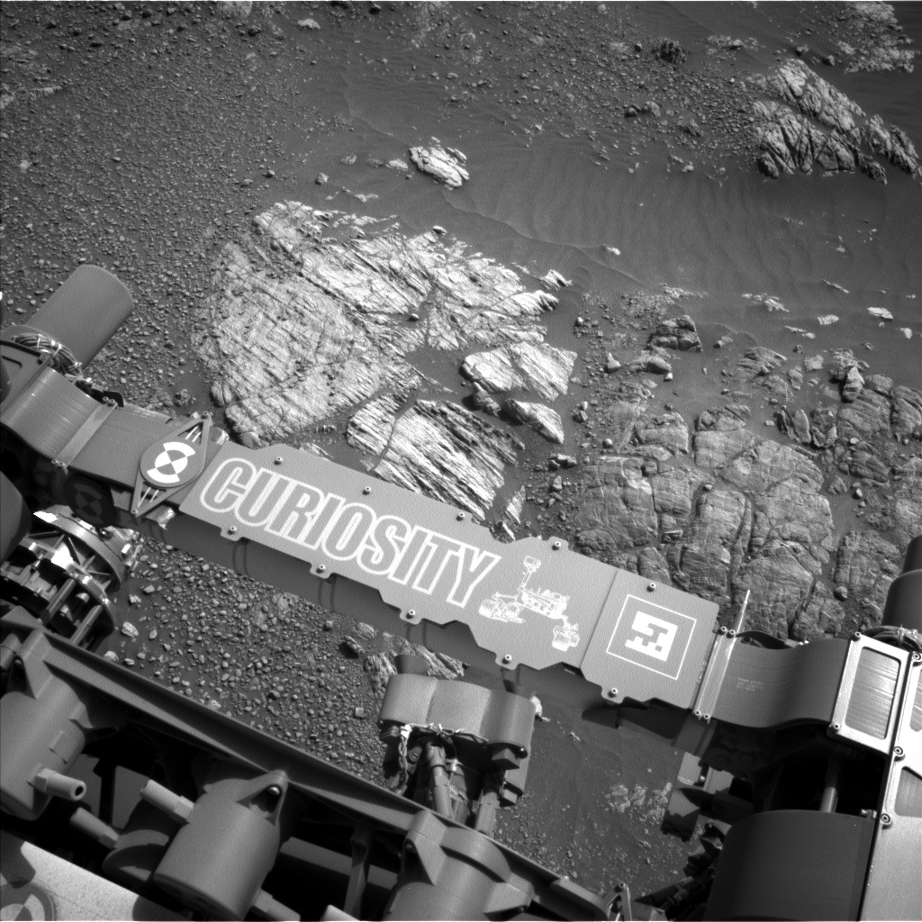
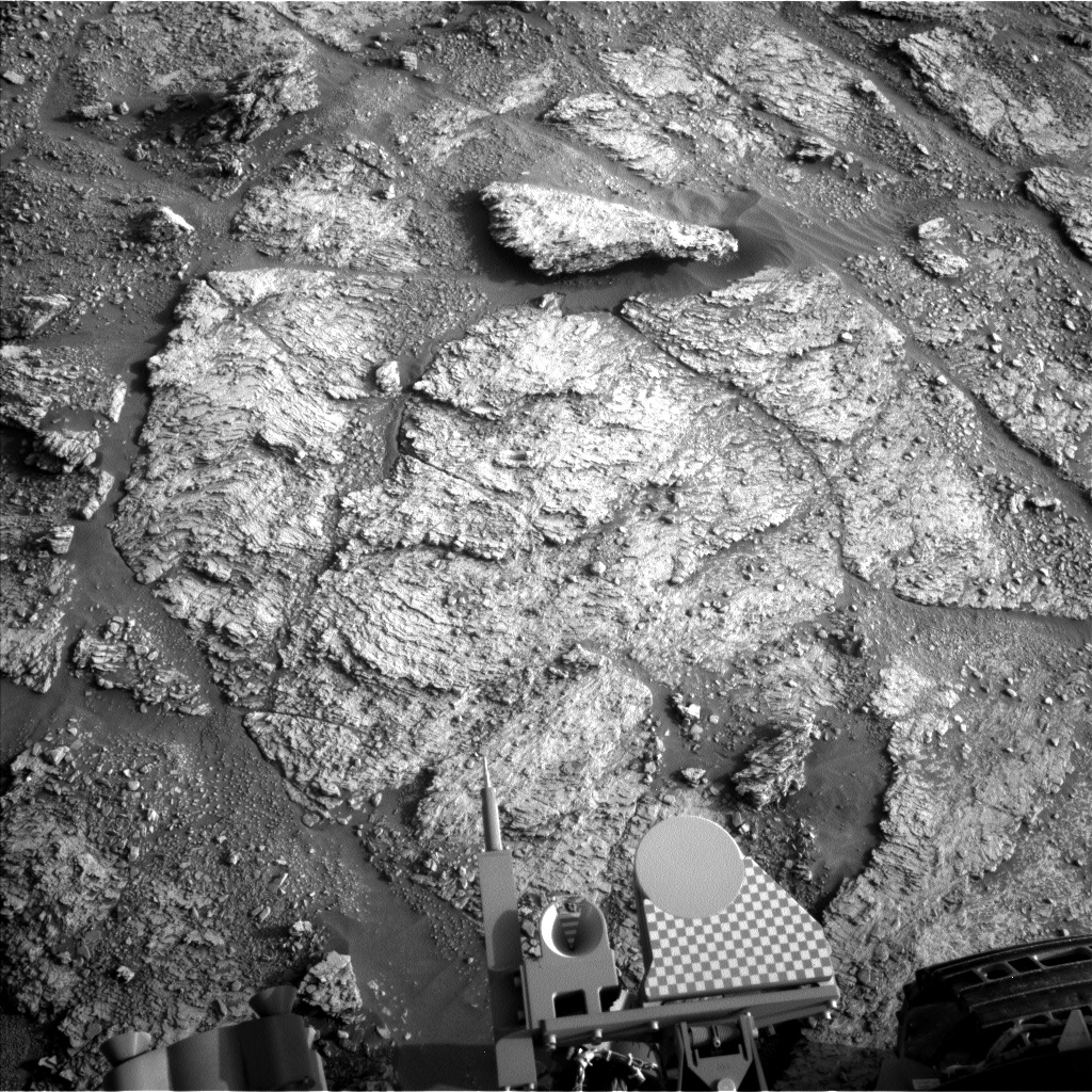
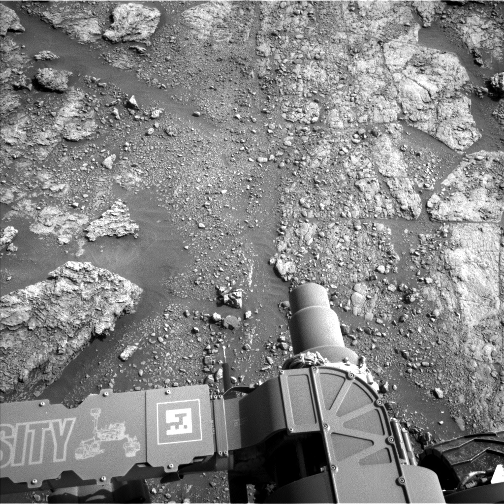
Curiosity is still parked in front of an outcrop known as "Sandside Harbour" in order to investigate differences in the lighter and darker outcrop expressions. Contact science in the previous plan went well, and today we have one more opportunity to look for differences in sedimentary structures and composition before driving on to the next outcrop.

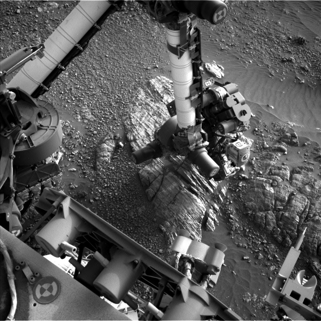
The plan starts with Mastcam multispectral observations to characterize the two different parts of this outcrop, as well as a unique fin of bedrock sticking out at "Joppa Shore." Mastcam will also be used to document some nearby stratigraphy at "North Minch" and an interesting green rock named "Halkirk." Then ChemCam will assess the chemistry of "Blackstones Bank" (part of the darker outcrop) and "Essendy" (a target on the lighter outcrop). We also planned a large Mastcam mosaic to document the "Sandside Harbour" outcrop. The main focus of the plan is to use the DRT, MAHLI, and APXS to characterize the darker outcrop for comparison with the lighter outcrop measurements that were taken previously. "East Shetland," shown in the right side of the above Navcam image, is the top priority today. We'll also acquire MAHLI and APXS on "Essendy," located on the left side of the above image. On the second sol, Navcam will monitor the atmosphere with a suprahorizon movie and dust devil survey. Then we'll drive west to another outcrop and take post-drive imaging to prepare for even more contact science on Monday. Curiosity will wake up early on Sol 2474 for some additional environmental monitoring activities.

I was the SOWG Chair today, and it was a fun day of planning. Rather than the usual 3-sol weekend plan, this plan is only two sols due to a soliday on Saturday (a day without planning to allow Earth and Mars schedules to sync back up). But I'd prefer to think that Curiosity is using the soliday to celebrate the 50th anniversary of the Apollo 11 moon landing, and appreciating those early explorers who laid the groundwork for the exciting work we get to do on other planets today!

July 22, 2019

Sol 2474: A Great Outcrop!

Written by Kristen Bennett, Planetary Geologist at USGS Astrogeology Science Center
Sol 2474: A Great Outcrop!

Today's one-sol plan included both remote science and contact science. The team planned a large Mastcam mosaic of the outcrop located to the south of Curiosity. The image above shows a Mastcam image of a different part of the outcrop that was imaged last week. When we see outcrops like this one that show a vertical exposure of laminated rocks, we capture it in high resolution Mastcam images so that scientists can look for sedimentary structures that give us clues as to how the rock formed.

The workspace today showed a lot of pebbles, plus a few small blocks. Two of the blocks, "Moine" and "Mither Tap," were targeted by MAHLI, APXS, and ChemCam.

In order to fit in all the science observations in today's plan, Curiosity will not be driving in this sol. Tomorrow the rover will likely keep rolling along the traverse!

July 17, 2019

Sol 2470-2471: A Way to Spend a Sol at Solway

Written by Scott Guzewich, Atmospheric Scientist at NASA's Goddard Space Flight Center
Sol 2470-2471:  A Way to Spend a Sol at Solway

Today, Curiosity finds itself parked in front of a fascinating area of martian bedrock with clearly lighter and darker colored areas next to each other as seen in the Navcam image above. This will be a "full" contact science location and the rover will spend the next few sols examining the rocks in this immediate area just in front of the Southern Outcrop. A target on the lighter-colored bedrock was termed "Solway Firth" and it will get a ChemCam LIBS target and the full dust-removal tool treatment before APXS and MAHLI observations. The second contact science location (without the dust removal) will be "Nith" on the darker-colored bedrock.

The second sol of today's plan will include a rare ChemCam image of the rover's drill bit to examine how it has been worn during our years on Mars. We are into the cloudy season on Mars and included two Navcam movies to study the water ice clouds that frequent the skies above Gale Crater in the afternoons and evenings this time of year. Lastly, Mastcam will take a large, and sure to be spectacular, mosaic of the nearby Southern Outcrop.

July 16, 2019

Sols: 2468-2469: Rolling Southward!

Written by Catherine O'Connell-Cooper, Planetary Geologist at University of New Brunswick
Sols: 2468-2469: Rolling Southward!

Image looks back at our traverse along Glen Torridon, away from Harlaw Rise

Curiosity finished up our investigation at Harlaw Rise on the weekend, and commenced our drive to an area we are (informally) calling the "Southern Outcrop," another of the ridge features that are so prominent in this part of Glen Torridon. This drive was split into a number of shorter drive segments. Our weekend drive brought us to a very rubbly workspace, with lots of small pebbles. These pebbles may be small but are geochemically interesting and add to our understanding of the geology here, so we are analyzing a pebble (about 4 cm along its long axis) called "Paible," before continuing on our way southward. APXS and ChemCam will both investigate the chemistry, and Mastcam and MAHLI will take colour images, giving us a full suite of observations to help with interpretation of this target. Mastcam will be taking a large image of an area of brighter rocks called "Sandside Harbor" at the Southern Outcrop.

Post-drive imaging of the new workspace will support contact science if we find ourselves in an interesting location, and a routine end of drive image of the ground at the back of the front left wheel will catalog changes in rock, soil and pebble populations. On the night of the second sol, CheMin will do some routine housekeeping activities ahead of a potential drill campaign, atop the Southern Outcrop in the coming weeks.

The Environmental Theme Group (ENV) has, as always, planned a very full suite of environmental monitoring activities, to run across the two-sol plan. A suite of Navcam movies will be taken to document clouds, variations in optical depth and winds in Gale crater - a "zenith" movie will look upwards, a "suprahorizon" movie will monitor clouds to the south of the rover, and a "dust-devil" movie will attempt to track wind vortices, which can give us information on surface heating and winds near the surface. At the top of each and every hour and in a series of extended hour-long measurements, the Rover Environmental Monitoring System (REMS) acquires temperature, pressure, humidity, and UV radiation measurements. DAN (Dynamic Albedo of Neutrons) continues its search for subsurface hydrogen, with frequent passive (utilizing cosmic rays as a source of neutrons to measure hydrogen) and post-drive active (actively shooting neutrons from the rover) measurements

July 12, 2019

Sol 2465-2467: Finishing up at Harlaw Rise

Written by Ken Herkenhoff, Planetary Geologist at USGS Astrogeology Science Center
Sol 2465-2467: Finishing up at Harlaw Rise

The Sol 2463 drive went as planned, leaving the rover in position to examine what appears to be a small dome in the sedimentary rocks (visible on the left side of the scene above). To determine whether the layers really do bow upward here, we planned an oblique MAHLI mosaic and a Mastcam stereo mosaic. MAHLI will also acquire full suites of images of bedrock targets "Ecclefechan" and "Kirbuster" after ChemCam has measured their chemistry and hopefully cleared off some dust using its laser. ChemCam will also observe a small, brighter outcrop named "Hatton" on Sol 2465. Later that sol, Mastcam will image the sun just before sunset, and APXS will perform short integrations on Kirbuster and longer, overnight integrations on Ecclefechan.

On Sol 2466, Mastcam will image the sun and the Gale Crater rim just after noon to measure the dust content in the atmosphere. Then Mastcam will acquire 3 stereo mosaics, of the possible dome in front of the rover, of the "Aitken Pit" area to the left, and of the top of Harlaw Rise before the rover drives away. During the drive around the east side of Harlaw Rise, the rover will pause to acquire Left Mastcam and Navcam stereo mosaics of that side of the rise before proceeding to the south. The usual Hazcam, Navcam, Mastcam and MARDI images will be acquired after the drive, along with some additional Left Mastcam coverage on the right side of the rover to help select ChemCam targets on Monday.

Navcam will search for dust devils to start off Sol 2467, then ChemCam will perform a series of calibration activities. Later that afternoon, Mastcam will again measure dust in the atmosphere and Navcam will search for clouds before and after sunset. Finally APXS will measure the composition of the atmosphere overnight. There are lots of complex activities in this plan, so it was a busy day for me as SOWG Chair; I'm glad that all of the desired observations made it into the plan!

July 11, 2019

Sols 2463-2464: A Fountain of Data

Written by Michelle Minitti, Planetary Geologist at Framework
Sols 2463-2464: A Fountain of Data

Curiosity continued work on and around the gorgeous outcrop pictured above that was started on Sol 2461. The layers of the outcrop - with their different colors, textures and thicknesses - tell us a story, one we worked to decipher in this plan with our full complement of contact and targeted science instruments. MAHLI and APXS will start by analyzing a grayish red target, "Tay," on a block adjacent to the one pictured. The team hoped Tay's grayish red color would be indicative of less dust cover; in other words, a chance for Tay to tell us a clearer story! ChemCam will shoot another gray target, "Donside," that resembles one of the thicker gray layers seen in the outcrop above, and "Fountainbridge," located on the farside of the outcrop where it exhibits a cracked texture. Off to the right of the rover, Mastcam will image a block, "Achmelvich," near the right rear wheel that was shifted during our last drive, revealing the steep face of a sand deposit sitting amongst the bedrock in the area.

Mastcam also turned its gaze to the scene above our lovely workspace, looking toward future sites of exploration. We planned a five image stereo mosaic of "Annan," our drive target in today's plan, and a 19 image stereo mosaic of "Craigeven Bay." Both Annan and Craigeven Bay exhibit bedding structures that caught the team's eye; stereo imaging will give us a better three-dimensional sense for those structures. MAHLI also got in on the landscape-imaging act, acquiring an image from the stowed position. MAHLI's view will incorporate our path over the last month or so. The last MAHLI stowed image was acquired over 700 sols ago!

Annan is not far from today's workspace - only about 7 m away. After the drive, we will unstow the arm to get a clearer look at our workspace. The short drive means we can still reliably target Mastcam at distant targets. Thus, Mastcam will gather multispectral data from outcrops that we will visit in the coming weeks and months. The hope is that these data will highlight differences among the terrains that are not apparent at visible wavelengths of light alone. Curiosity will briefly look skyward, acquiring Navcam and Mastcam images looking for clouds and measuring atmospheric opacity. CheMin completes the plan with an activity to make sure one of its reusable cells is empty and ready for the next sample.

July 8, 2019

Sols 2461-2462: What Would We Do Without MAHLI?

Written by Roger Wiens, Geochemist at Los Alamos National Laboratory
Sols 2461-2462: What Would We Do Without MAHLI?

MAHLI was busy over the weekend. The data from Mars returned a trove of close-up images from the outcrop near the top of "Harlaw Rise," including the one shown here. Along with outcrop images, MAHLI took pictures of the rover wheels to check for wear and tear. Those images can be seen at this link. Although the wheels have developed some holes, the testing and modeling that have been done since early 2014 indicate that Curiosity can still travel a number of kilometers on these wheels.

Today the team was busy planning two sols of activity. The rover moved only three meters over the weekend, so it is not far from last week's activity. MAHLI will be active again, getting a "dog's eye view" of laminated target "Strathdon." MAHLI, APXS, and ChemCam will all investigate the top of the same block, with the target name "Feshie" as well as a nearby block named "Sligachan." ChemCam and Mastcam will observe 'Shapinsay" at the base of the block that has the targets "Feshie" and "Strathdon." ChemCam and Mastcam will also take long-distance images of the sulfate unit, which is uphill from this location. Navcam will look for dust devils and will also take a horizon movie. RAD, REMS, and DAN will all take data, as usual. Curiosity will stay in place until later in the week.

July 3, 2019

Sols 2457-2460: A busy holiday weekend!

Written by Mark Salvatore, Planetary Geologist at University of Michigan
Sols 2457-2460: A busy holiday weekend!

Curiosity will continue to investigate the rocky Harlaw region of the Glen Torridon formation on this holiday weekend. Curiosity arrived at her current location on Monday and has been investigating some interesting layered bedrock material over the past few days. Today's planning was for the next four sols, where Curiosity will continue her investigation of this area before a short drive to the south on Saturday. In the plan for the first sol, Curiosity will use the ChemCam instrument to analyze the chemistry of four bedrock targets representative of the surrounding region and potential alteration features: "Benfiddich," "Orbost," Dunnet," and the appropriately named "Forth" (not the same spelling as the Fourth of July, but close enough!). Overnight, the APXS instrument will make a long measurement of its calibration target. On the second sol, Curiosity will acquire high resolution images of future targets further to the south and will make several measurements and observations of atmospheric phenomena. Overnight, she will use the APXS instrument to accurately measure the chemistry of two bedrock targets. On the third sol, Curiosity will make a short drive to a new target location still within the Harlaw region. During the drive, she will image her wheels using the MAHLI high-resolution camera to assess the health and performance of the wheels. Finally on the fourth sol, Curiosity will spend the day making environmental measurements with the REMS instrument. This will put us in great position to continue our investigation of the clay-bearing Glen Torridon formation early next week.

July 2, 2019

Sol 2455-2456: Investigating laminated rocks.

Written by Susanne Schwenzer, Planetary Geologist at The Open University
Sol 2455-2456: Investigating laminated rocks.

Image taken by Curiosity's front hazard camera, on Sol 2454 Earth time 2019-07-02 13:28:09 UTC. It shows the APXS instrument on one of the larger blocks at Harlaw.

The 4th of July is coming up - and so the team worked to keep the rover busy without keeping ourselves busy! Today Earth time we planned two Mars sols, and tomorrow Earth time we will complete an over-sized weekend plan that will keep Curiosity busy while we celebrate 4th of July on Earth. Parts of the plan are dedicated to engineering activities and preparation for the next CheMin measurement. For the former, the most important part is a full MAHLI wheel imaging, which we do in regular intervals to monitor the health of our wheels. The latter is a CheMin empty cell analysis, so we know that we have a clean cell prepared and ready for the next drill activity. While the next drill location is not decided yet, we still use the time available during longer planning intervals to do those activities.

But there was remote science, too. We planned two ChemCam LIBS targets, one on the target "Culross" and the other one on the target "Corston." They are different in their textures and it is important to document if they are also different in their chemistry - if they are, we will find out when we come back from the holiday. In the image above, which shows the APXS on a rock a few sols ago, you might notice the lamination of the rocks. With so many sedimentary features to observe and understand, we planned a large Mastcam mosaic of the top of the ridge, so we and indeed all our colleagues around the world can study all those details and decipher the environmental condition at the time of deposition. Last but not least, we are also looking into the distance with Mastcam to an area within the "Visionarium" informally named "Eastern Outcrop." There, too, interesting sedimentary structures attracted our attention.

July 1, 2019

Sol 2454: Exploring Harlaw Rise

Written by Melissa Rice, Planetary Geologist at Western Washington University
Sol 2454: Exploring Harlaw Rise

Curiosity is currently near the top of Harlaw Rise, having made a slight diversion from the southward drive through the clay-bearing unit to explore the nice exposures of rocks on this hill. In today's plan, Curiosity will investigate two rock targets in front of the rover: "Perth," on the block in the lower left of the image above, and "Aberdeen," on the smoother surface near the far right-hand side of the image. There is only enough time in this plan to put the arm on one of these two targets, so Perth will get a closer look with the MAHLI microscopic imager and APXS instrument, and "Aberdeen" will get shot by the ChemCam laser. The Mastcam cameras will document both targets. After that, Curiosity will make a short drive further up the hill to a spot where both of these rock types might be better exposed.

Why do we give names like "Perth" and "Aberdeen" to Curiosity's rock targets? How does the largest city in Western Australia end up right next to a Washington State timber town? As a Long-Term Planner for the Curiosity science team, one of my responsibilities is to keep track of the names that the team uses, and to make sure that they fit within the theme for this portion of the rover's traverse. Curiosity is currently in a region of the team's geologic map called the Torridon Quadrangle, named after a village in the Northwest Highlands of Scotland, which is near an important geological formation called the Torridonian Supergroup. Therefore, all of the names assigned to targets in this region of Curiosity's traverse come from landforms, geologic formations, and towns in that part of Scotland. So the namesakes of today's "Perth" and "Aberdeen" rock targets on Mars are the same as those of all the other Perths and Aberdeens out there: Perth, Scotland, and Aberdeen, Scotland.

Happy Canada Day today, especially to those in Perth, Ontario, and Aberdeen, Saskatchewan!