August 5, 2019

Sol 2488: Success on the 22nd Drill Hole; Happy Landing Day--On to Year 8!

Written by Roger Wiens, Geochemist at Los Alamos National Laboratory
Sol 2488: Success on the 22nd Drill Hole; Happy Landing Day--On to Year 8!

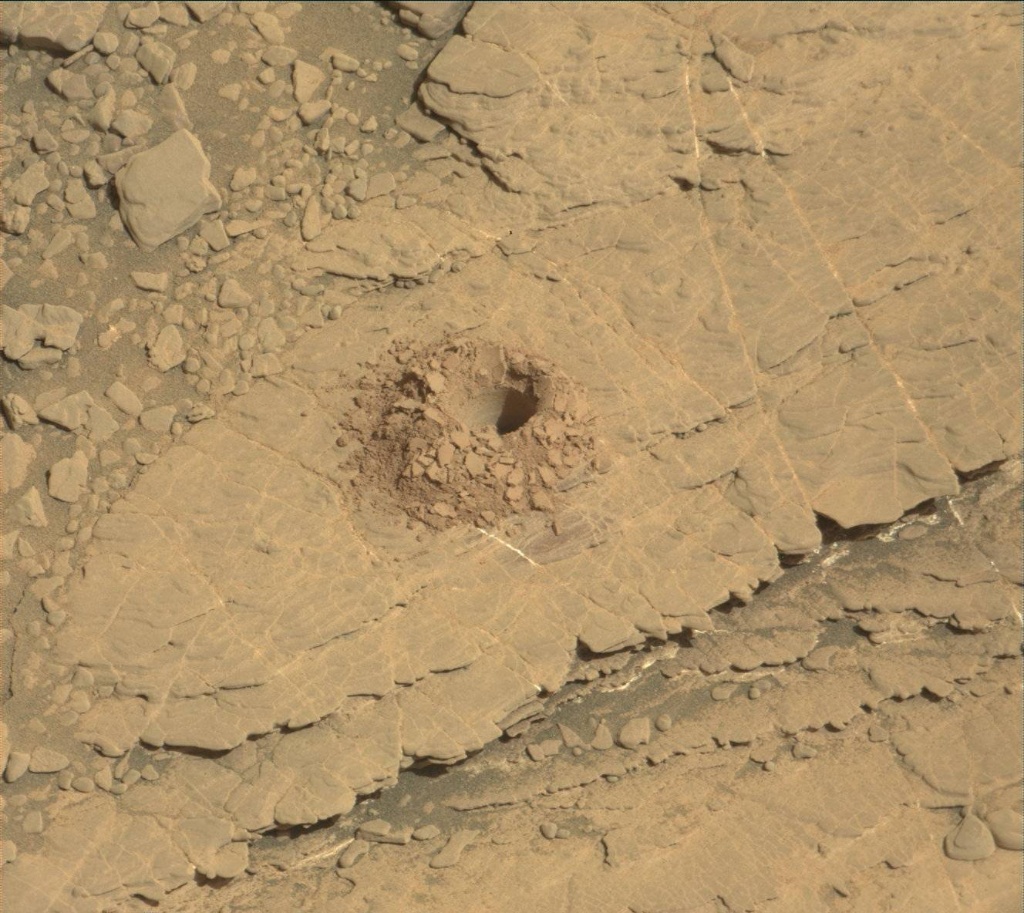
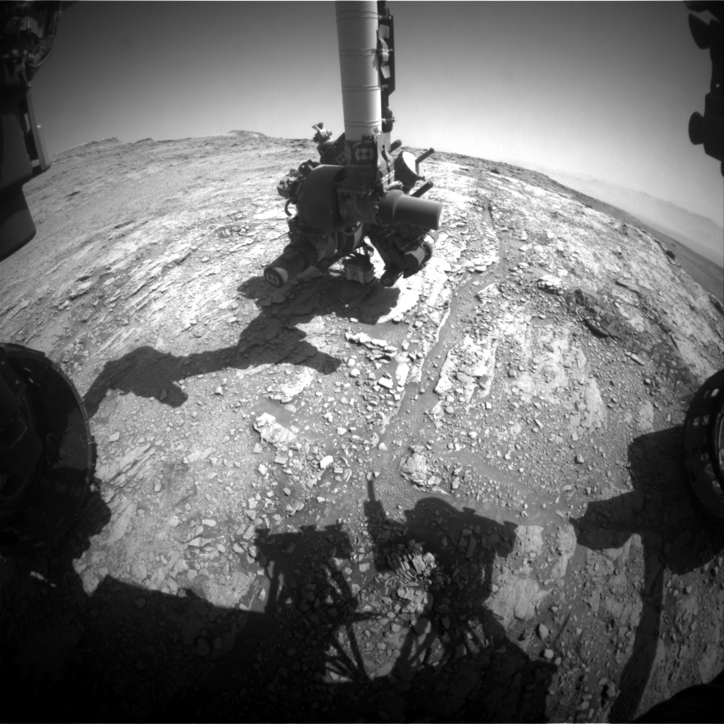
On Sunday morning the team received the message that Curiosity's latest drill hole was successful at "Glen Etive." This is the 22nd full-depth drill hole on Mars, and we can celebrate its success on this final day of Earth-year 7 of the mission. "Glen Etive" is the third hole in the clay unit. The other two holes, "Kilmarie" and "Aberladie," were drilled near each other in April at a lower stratigraphic position. This hole was achieved with no percussion, and its depth is > 4 cm. Tailings from the drill hole will be used for analyses of this outcrop by the SAM and CheMin instruments. The tailings will also be characterized by APXS, MAHLI, Mastcam, and ChemCam.

The operations and analysis surrounding a drill activity are well scripted, though not always easy. In today's plan, ChemCam will attempt to shoot down into the drill hole to analyze the rock layers on the wall of the hole. These are fresh rock surfaces and should generally represent the same material that SAM and CheMin analyze. It is dark in the hole, so the autofocus feature of ChemCam is significantly challenged. Getting a good image down the hole requires overexposing the other parts of the image so we can see better in the dark part of the hole. Early in the mission during my public talks, I would demonstrate the pointing accuracy needed to do this activity by tossing a dime down on the stage a few feet away and pointing at it with my laser pointer. The drill hole is the size of a dime. Making ChemCam laser observations up and down the drill hole wall is about like holding the laser pointer steady at different positions on Roosevelt's cheek on the face of the dime, lying on the floor.

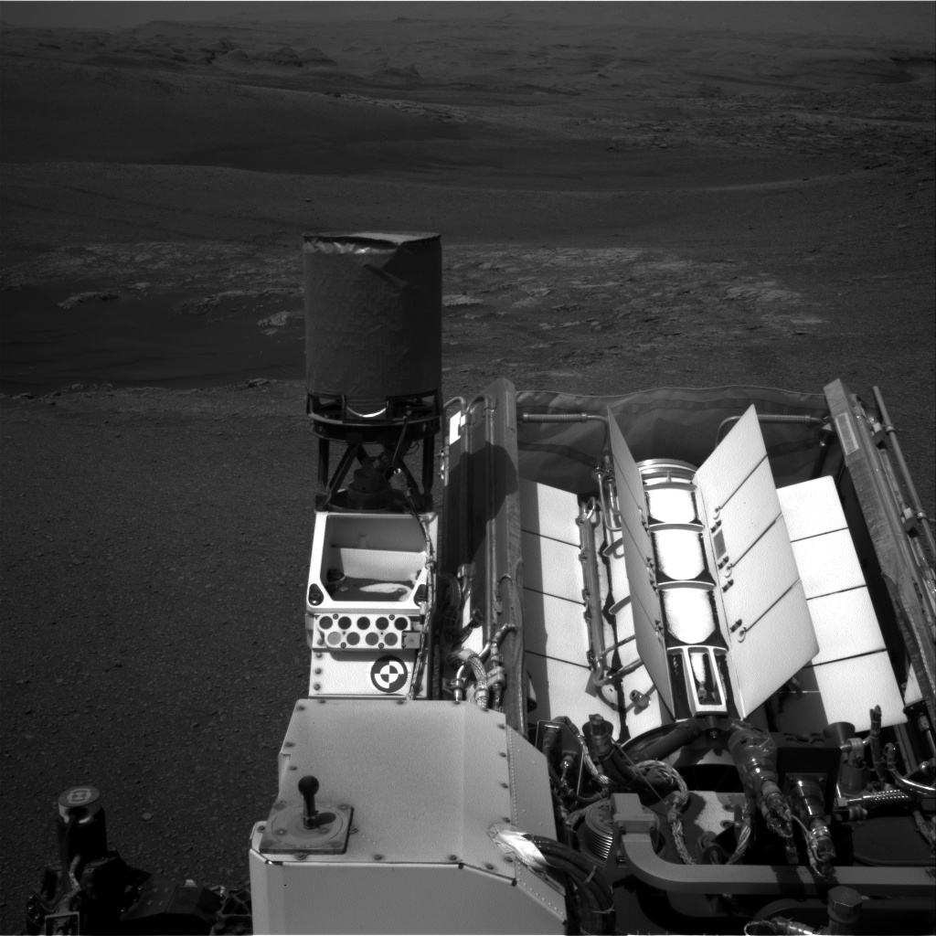
Meanwhile, the arm will be busy with drill portion characterization. The activity creates "test portions" in order to make sure that there is sample material in the drill and that the portions are of the expected amount (for instrument safety). One is delivered to the ground and two to the back of the closed SAM inlet cover. The latter is the best "rehearsal" for dropping portions to the instruments, since it also allows us to gauge the amount of deflection by wind at the height of the rover deck. Mastcam images are used for documentation in all cases.

Mastcam will also take a mosaic of the area around the drill hole, and ChemCam will shoot one additional nearby target, "Argyll." The Hazcams will take images for a slip check of the rover. Navcam will do a dust-devil movie and a horizon movie to look for clouds. RAD, REMS, and DAN will also take data.

August 2, 2019

Sols 2485-2487: Affirm-Etive: We Are GO for Drilling at Glen Etive 1!

Written by Lucy Thompson, Planetary Geologist at University of New Brunswick
Sols 2485-2487: Affirm-Etive: We Are GO for Drilling at Glen Etive 1!

~35 cm standoff MAHLI image of the Glen Etive 1 target after brushing and the preload test.

Late during planning yesterday, we got the go ahead to proceed with full drilling at "Glen Etive 1." We received the results of the APXS and ChemCam compositional analysis of the prospective drill target, as well as the MAHLI imaging of the area both before and after a preload test (see the accompanying image). The preload test is exactly what it sounds like; exerting a load onto the surface bedrock to check that it can withstand the force of drilling. The engineers and science team assessed the results of these analyses and concluded that it is safe to drill the Glen Etive target. Therefore, the weekend plan is dominated by the drill activity, which will take place on the second sol of the plan.

We managed to fit in some environmental science and a Mastcam 360°mosaic of our surrounding terrain on the first sol of the plan to provide context for our drill site, prior to the rover going to sleep in order to recharge itself for the power intensive drilling. The environmental observations include a ChemCam passive sky observation, a rear Hazcam dust devil movie, a Mastcam crater rim extinction and basic tau pointed towards the sun.

We filled a post-drill science block with geological observations. These include observations of what will hopefully be a new drill hole and associated tailings on Mars, with ChemCam passive spectroscopy and remote microscopic imaging as well as Mastcam multispectral imaging. ChemCam will also continue to investigate the variation in chemistry of the bedrock in the vicinity of the drill target, firing its laser at the "Clarkly Hill" target. Mastcam will document the ChemCam target.

Curiosity will wake up the next morning for an early morning science block with some more environmental monitoring including a Mastcam full tau pointed towards the sun, a Navcam zenith movie, suprahorizon movie, line of sight image and 360°sky survey. Standard background REMS, RAD and DAN passive measurements are also planned.

Everyone on the team will be eagerly awaiting the first downlinked data after the drill activity, to see if we have our 22nddrill hole on Mars destined for Curiosity's analytical lab. If successful, next week should see drop off of sample to CheMin and the preliminary mineralogical results, which we can compare with previous drill holes within Glen Torridon and the Murray formation.

August 1, 2019

Sol 2484: Preparing to Drill

Written by Mark Salvatore, Planetary Geologist at University of Michigan
Sol 2484: Preparing to Drill

Today's science activities were planned with the hopes of drilling our next target this weekend. The scientists on today's shift were largely interested in characterizing the large block of exposed bedrock in front of the rover to derive as much information as possible before we punch through the surface and expose the rock's interior. Last evening, Curiosity brushed the dust off of the rock and made some geochemical measurements using the APXS instrument (see image). For today, we planned to acquire a multispectral image of this brushed surface in addition to two remote laser induced breakdown spectroscopy (LIBS) measurements of the bedrock's chemistry to determine whether there is spatial variability in the chemistry of this geologic unit. We also have an opportunity to acquire a large Mastcam mosaic of the large and flat geologic feature to the south of Curiosity known as the Greenheugh pediment. This enigmatic feature has been a target of interest ever since Gale crater was first being considered as a potential landing site for the Curiosity rover, and so documenting it from this new vantage point has been a high priority for the geologists on the team.

Today's activities will put us in a good place to drill this unit over the weekend, followed by several additional days to document the new drill hole and the tailings. If all goes well, we should receive additional geologic data from the rover's instruments on the mineralogy of this unit sometime next week. It'll be great to compare this location with the other drill holes acquired since the investigation of Vera Rubin ridge.

August 1, 2019

Sol 2483: Anticipating Drill Hole Number Three (And Maybe Number Four) Within Glen Torridon

Written by Lucy Thompson, Planetary Geologist at University of New Brunswick
Sol 2483: Anticipating Drill Hole Number Three (And Maybe Number Four) Within Glen Torridon

Mastcam left image of the block we plan to drill this weekend.

Planning today was focused on getting more compositional and textural information on top of this small ridge that we plan to attempt drilling at the weekend. This ridge is representative of one of the units mapped from orbit prior to landing, the "fractured clay bearing unit." We previously drilled two holes into the "smooth clay bearing unit" and it will be interesting to compare the composition and mineralogy of these orbitally distinct units to each other and with the rest of the Murray formation.

We will use ChemCam to investigate the composition of two more spots ("Glen Dessary" and "Canisbay") on the same block that we intend to drill to see if different layers have the same chemistry, and will get Mastcam documentation imaging of these targets.

We had the potential for two separate contact science targets in the plan today and discussed whether we wanted two APXS (chemistry) and MAHLI (imaging) targets or whether we wanted to devote one of those targets to MAHLI oblique imaging of the layers in the block we plan to drill (as opposed to imaging just the top surface). We decided to brush, get APXS and MAHLI on the second potential drill target "Glen Etive 2," and then do the MAHLI oblique imaging to hopefully inform us of the third dimension that we will encounter when we drill, as well as of any sedimentary structures present.

Standard environmental activities rounded out the plan with REMS, RAD, DAN active and passive, Mastcam crater rim extinction and basic tau of the sun, and a Navcam suprahorizon movie.

July 30, 2019

Sols 2482-2483: A Drill with a View

Written by Mariah Baker, Planetary Geologist at Center for Earth & Planetary Studies, Smithsonian National Air & Space Museum
Sols 2482-2483: A Drill with a View

The rover is currently located in the southern part of the "Visionarium," where we are set to start our next drill campaign, and we can't help but take in the scenery! Perched on top of a small escarpment, we have arguably one of the best backdrops we have ever had during a drill campaign. The stunning panoramic views of Mount Sharp and surrounding terrains (like those seen in the Navcam image above) could truly take one's breath away - if the lack of oxygen wasn't enough!

Today marked drill Sol 1, which meant the team was focused on locating and prioritizing drillable rocks in our workspace. The target "Glen Etive 1" was selected as the primary drill option; ChemCam, MAHLI, and APXS measurements on Glen Etive 1 will provide information on the geologic and chemical properties of this rock before we start to drill. ChemCam will also target another spot on the same rock layer ("Glen Etive 2") as well as a target on another outcrop nearby ("Ninian"). We also included various Mastcam observations in tosol's plan, such as documentation images of the three ChemCam targets, a stereo image of a layered rock target called "Liddel," and a larger mosaic image of a distant sandstone unit. A set of environmental measurements rounded out the plan, including two DAN activities, REMS monitoring, and Navcam images to monitor dust loading and dust devil activity.

The team is eager and ready to jump into drilling at this new location, especially given the picturesque backdrop we get to enjoy while we work. And since a full drill campaign can last weeks, we can continue to revel in the beauty of Gale crater's vast and diverse landscapes for at least a little while longer.

July 29, 2019

Sol 2481: On the Lookout for a Drill Site

Written by Vivian Sun, Planetary Geologist at NASA's Jet Propulsion Laboratory
Sol 2481: On the Lookout for a Drill Site

After a successful ascent to the top of the southern outcrop in the "Visionarium," we are now searching for our next drill site. There were no bedrock exposures available for contact science activities in our immediate workspace, so our first order of business today was to identify a drill site area that we will drive to in today's plan.

There are a number of factors we considered when selecting this drill site. We looked for bedrock that looked "in-place," meaning bedrock that likely has not been moved since it formed. While there can be "out-of-place" rocks (or "float" rocks) that are interesting, in-place bedrock can be more stable for drilling and its geologic context is simpler to interpret. We also prioritized larger bedrock exposures, as we need room to drill, discard, and analyze the sample. The size of the bedrock slab is even more important than usual at this location because we may consider drilling a second time and delivering sample for a possible SAM wet chemistry experiment. Lastly, we considered other practical constraints, like finding an area that gives us a good parking position and a level surface to drill on. Considering all of these factors, we identified several candidate sites and finally decided to drive to a relatively flat slab that is visible in the right portion of the above image.

With the major drive decision out of the way, we then proceeded to plan the rest of the observations at our current location. Since we weren't doing contact science, we obtained some extra time for remote sensing activities and planned three ChemCam measurements of some nearby bedrock ("Blaven," "Glen Lyon," "Glen Orchy"). We also planned a large Mastcam mosaic of the bedrock exposures in front of us, dubbed the "Hebrides" region, which we imaged in the previous plan from a different angle. Imaging this area before we drive up to our drill site will help us examine sedimentary structures and provide context for our future drill sample. In addition to these observations, we also planned a suite of atmospheric observations including Navcam dust devil movies, crater rim extinction, and Mastcam tau observations. There is much to look forward to in the upcoming days, with the start of our next drill campaign and excellent views from our future parking spot!

July 27, 2019

Sol 2478 - 2480 - Goin' Up

Written by Abigail Fraeman, Planetary Geologist at NASA's Jet Propulsion Laboratory
Sol 2478 - 2480 - Goin' Up

Over the last few weeks Curiosity has collected hundreds of spectacular images, like the one above, that document the layers and textures of rocks exposed in the "Visionarium." (And as we heard in the last blog, we also set a mission record yesterday for having the highest tilt we've ever had while conducting contact science -- over 25 degrees!) With all of this imaging under our belt, we're now hoping to delve deeper into studying the composition of the rocks in the Visionarium, so we are beginning to look for our next potential drill target.

In the plan for the weekend, Curiosity will drive ~10 m to the top of the southern escarpment in the Visionarium. The drive will place us in an ideal location to image potential future drill targets. Before the drive, we'll spend a sol collecting MAHLI and APXS data from targets named "Naver" and "Fetterangus," along with ChemCam and Mastcam observations of "Malin Sea," "Loch Katrine," and "Loch Broom." We'll also take several environmental science monitoring observations, and an 80 frame stereo Mastcam mosaic of "Hebrides," which is the area where we hope to find our next drill target.

On a personal note, today was an extra fun day of planning for me because I was joined by several science team members during my shift at JPL. Because members of the science team are located all over the world, we usually need to work with phone lines and screen sharing tools to develop our tactical plans each day. However, a lot of scientists traveled to Pasadena, CA, to attend the 9th International Conference on Mars that happened earlier this week, so it was excellent to have them available at the end of the conference to participate in operations in person at JPL!

July 25, 2019

Sol 2477: Records measured in degrees

Written by Susanne Schwenzer, Planetary Geologist at The Open University
Sol 2477: Records measured in degrees

Image taken by Curiosity's Navcam: Left B (NAV_LEFT_B) onboard NASA's Mars rover Curiosity on Sol 2476 (2019-07-25 06:04:28 UTC). It is pointed at Mt. Sharp and shows impressively just how steep a tilt the rover currently has.

Europeans, Californians… and many others on the team watched their thermometers rise to record highs today, reaching 36 °C in this blogger's hometown "Milton Keynes." Thinking about planning, where we currently think about cold, wintertime temperatures on Mars and tosol's maximum temperature was -30 °C according to REMS, this 66 °C difference in temperature is a very practical demonstration of orbital mechanics and other factors, and more generally how different Earth and Mars are!

Temperatures are not today's most important record, though: Curiosity is currently tilted 25° - more than ever before, during science operations. The image above shows just how much this is. Never mind that slope…., Curiosity will get her arm out to investigate the outcrop in front of her. Since lamination and other sedimentary features are exceptionally well accessible, we planned a MAHLI dog's-eye mosaic to study all the details on this target called "East Caithness Cliff." ChemCam will target some of the layers of East Caithness Cliff for chemistry. APXS is busy on the target "Cruden Bay," which is also part of the outcrop but at a lower level than the MAHLI mosaic. Curiosity will then drive away to reach the top of the ridge. Tomorrow she should be on closer-to-horizontal ground - which hopefully comes with a first view of the top of this ridge.

July 24, 2019

Sol 2476: The Southern Escarpment Almost Within Reach

Written by Ashley Stroupe, Mission Operations Engineer at NASA's Jet Propulsion Laboratory
Sol 2476: The Southern Escarpment Almost Within Reach

This morning Curiosity found herself parked at the base of the southern escarpment of the Visionarium. She's at a significant tilt of 21 degrees; you can see the slope of the horizon in the attached image. We've been imaging this ridge from several locations over the past few sols, trying to build up our understanding of the geology in this area. In today's plan Curiosity will continue taking high resolution images of the outcrop with Mastcam and ChemCam; three specific areas are being targeted on the outcrop to see details of the various layering: "Antonine Wall," "Tyrebagger Hill," and "Seaton Cliffs."

After completing the imaging, Curiosity will be driving just a little bit closer to try to put the layers near Tyrebagger Hill into the arm workspace. This requires backing up a short distance, turning slightly, and then re-approaching the ridge at a slightly different location, where we believe parking will be safe to unstow the arm for contact science, including low-angle MAHLI images of the layers. We may get close to or even break Curiosity's high tilt record on this drive!

July 23, 2019

Sol 2475: Powering Through!

Written by Dawn Sumner, Planetary Geologist at University of California Davis
Sol 2475: Powering Through!

It's winter for Curiosity, and it's cold. That means that we have to spend extra energy heating up the instruments and motors for our activities. All of our energy comes from batteries, charged by the RTG. The RTG gives us more power than solar panels would, but in the winter, we are still limited by the amount of power it can generate. That means we have to choose among various activities.

Tosol (today on Mars), we chose to save a little extra power for a big science day solorrow (tomorrow on Mars). Thus, we planned only one ChemCam analysis, which was on the target "Monreith," accompanied by a Mastcam image to document the analysis. We also asked Curiosity to take a Mastcam mosaic looking west to document the topography. After playing photographer, Curiosity will drive up to the escarpment we've been imaging to the south (see yestersol's update). Once there, Curiosity will image its surroundings as well as look for clouds in the sky. Winter is the cloudy season at Gale Crater, so we are doing extra cloud imaging to better understand the atmosphere.

Seasonal changes provide important insights into the climate of Mars. Thus, winters are particularly interesting times for environmental observations even if the cold means that we can't take as much data as we can in the warmer months.