January 11, 2020

Sols 2642-2644: Contact Science at Western Butte

Written by Lauren Edgar, Planetary Geologist at USGS Astrogeology Science Center
Sols 2642-2644: Contact Science at Western Butte

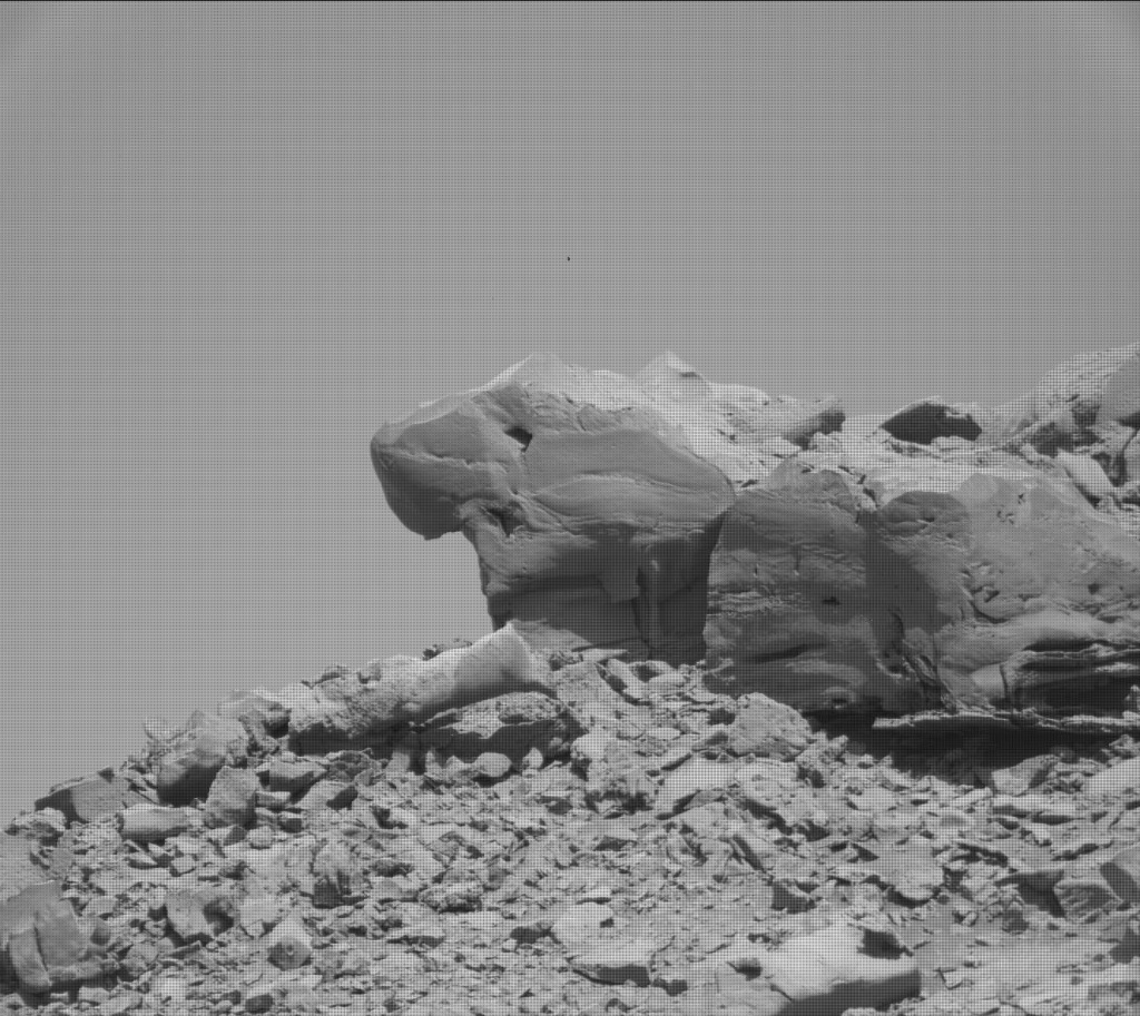
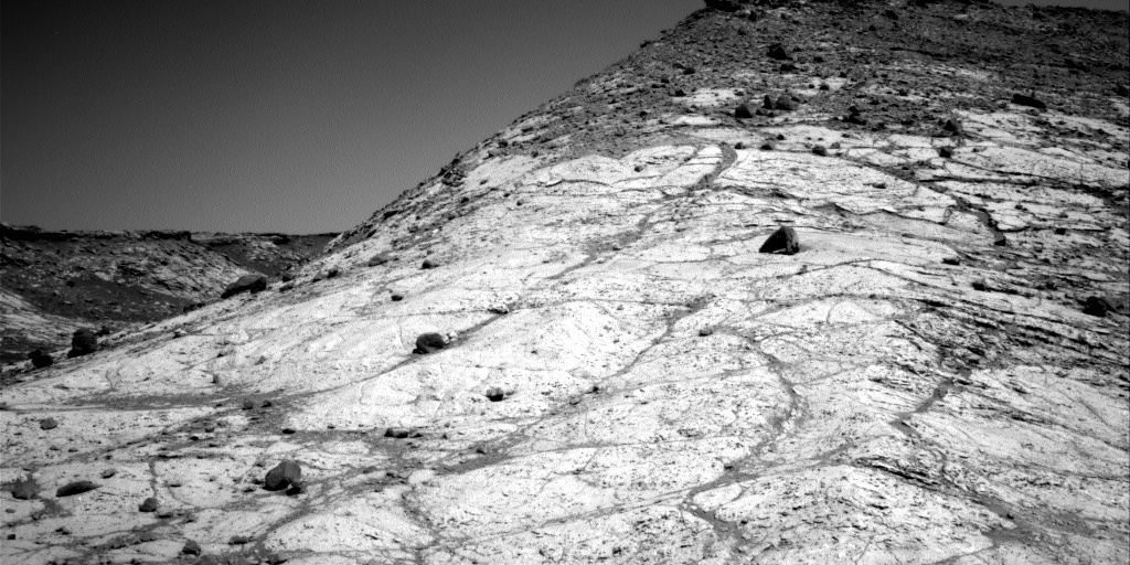
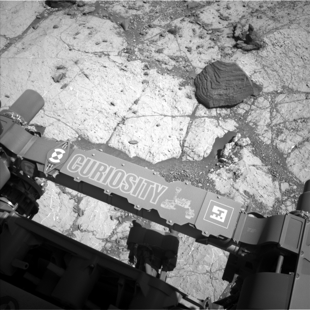
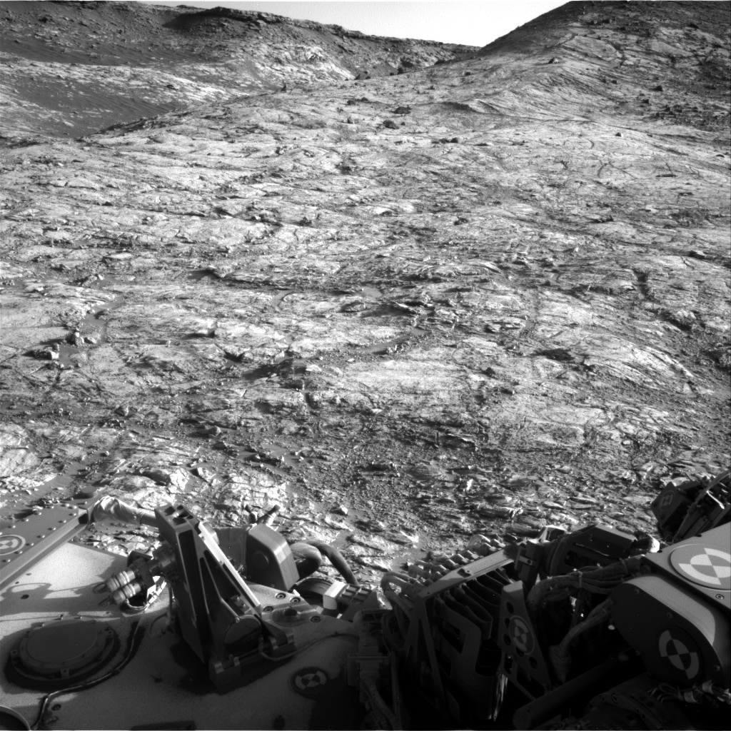
Curiosity is still on the shoulder of Western Butte at a location that provides a good vantage point, exposes changes in stratigraphy, and reveals some interesting float blocks in our workspace. On Wednesday (planning Sols 2640-2641) we were able to conduct contact science on a bedrock target named “Buchan Haven,” as seen in the above MAHLI image, which also shows where the Dust Removal Tool (DRT) cleared away a fresh surface. The three sol weekend plan is our second opportunity to do contact science here.

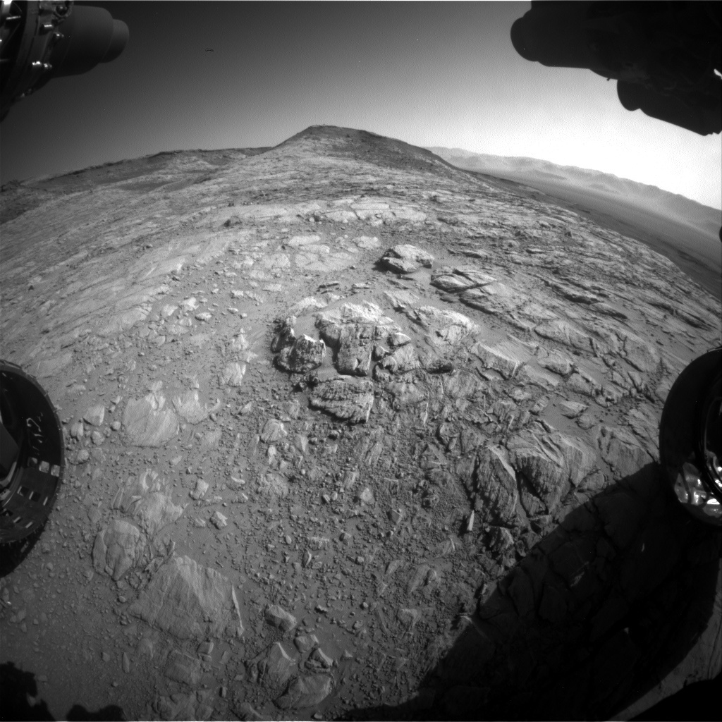
I was the SOWG Chair today, and it was a pretty busy day of planning. The plan kicks off with several ChemCam observations to assess the chemistry of a nodule target “Strathy Point,” a vein target “Abernethy,” and bedrock target “Glen Clunie,” along with Mastcam documentation of these rocks. Then MAHLI and APXS will be used to characterize the grain size, sedimentary structures, and chemistry of “Lomond Hills” (a dark float block that might represent the butte capping unit), and “Abernethy” (an interesting vein). The second sol includes additional remote sensing, with several long distance RMI mosaics to assess the stratigraphy of the pediment and Gediz Vallis ridge, and a Mastcam multispectral observation of a light-toned vein at “Hascosay.” The Environmental theme group planned a number of atmospheric monitoring observations, including a Mastcam tau, crater rim extinction, Navcam line of sight, and dust devil and suprahorizon movies. Then Curiosity will drive ~45 m to the northeast, down the eastern slope of the butte. After the drive we’ll acquire imaging to help with context and targeting for next week. On the morning of Sol 2644, Curiosity will acquire additional environmental monitoring observations, and then run a SAM atmospheric methane observation.

January 9, 2020

Sols 2640-2641: Like a Dog Under the Table…

Written by Roger Wiens, Geochemist at Los Alamos National Laboratory
Sols 2640-2641: Like a Dog Under the Table…

The Curiosity rover is still at the highest point it will reach on “Western Butte,” having done a short bump to allow it to do contact science. You can check out the map of Curiosity’s location here. The team would like to understand the composition, morphology, and ultimately, the origin of the capping unit of this butte. An image of this capping unit is shown above, taken by the Mastcam M100 camera on Sol 2635. The rocks look really interesting and unusual, but the butte is too steep to drive to the top to sample them. Fortunately, nature is kind to us, and somewhat like humans drop scraps to their pet dog under the table, nature has rolled some samples down to where the rover is. Some of those samples were highlighted in an earlier post. I gave a presentation within the team today on the first results of those rocks, while the rover makes more observations of them and of other features in the area.

Today the team planned two action-packed sols. Our planning session started rather late due to the lateness of the data downlink. This plan is a big opportunity for contact science, as the rover is on stable ground after being for several days with a wheel perched on a rock. Targets “Buchan Haven” (overnight) and “Heinrich Waenke” will be observed by APXS. The DRT is planning to be used. MAHLI will take images of “Abernethy,” “Lochmond Hills,” “Buchan Haven,” and “Heinrich Waenke” (as close as 1 cm standoff distance). Additionally, there are Mastcam images of “Hangingstone Hill” (a dark float rock, potentially from the capping unit), “Strathy Point” (a nodule), “White Rashes” (local bedrock), and a 15x8 “Glen Torridon Mount Sharp Ascent Route” mosaic with the M100 camera. Mastcam will also observe “Buchan Haven,” “Crianlarich Hills” (2 images), and will take an image of the calibration target. ChemCam will do a combination of long-distance imaging and compositional analyses of targets near the rover. The latter are “Hangingstone Hill,” “Strathy Point,” and “White Rashes,” mentioned above. The long-distance mosaics are “Glen Docherty” and “LD Sulfate 2640a.” Navcam will take a dust-devil movie. There is also a DAN active observation, a SAM scrubber activity, a Mastcam full tau, and RAD and REMS get-data activities.

The contact-science target “Heinrich Waenke” honors a late German scientist of that name (1928-2015) who was instrumental in the development of the APXS instrument, which was originally on the Sojourner rover, then was used on MER, and is now on MSL.

January 8, 2020

Sol 2639: SAM Is Feeling Better

Written by Kenneth Herkenhoff, Planetary Geologist at USGS Astrogeology Science Center
Sol 2639: SAM Is Feeling Better

Sunrise was late this morning in Earth's mid-northern latitudes, so I made a point of looking for Mars before dawn when I woke up. It was easily visible above Antares, the brightest star in Scorpius, named "not Mars" in Greek because it is about as red and bright as the planet. Seeing that point of light in the morning sky reminded me how far away Mars is, and how fortunate we are to be operating a rover on its surface.

Later this morning, when planning began for Sol 2639, SAM was still marked sick, so the strategically planned bump was replaced with targeted science. Mastcam will extend the stereo mosaic of Western Butte and take a multispectral set of images of the "Ben Eighe" outcrop (upper right of center). After the re-planned bump to fix the wheelie, the AEGIS software will be used to autonomously acquire ChemCam observations of 2 targets in the new workspace, Navcam will search for dust devils, and MARDI will again acquire an image of the ground behind the left front wheel during twilight.

Late during tactical planning this afternoon, SAM was marked healthy, so things are looking up for Sol 2640-2641 planning tomorrow.

January 7, 2020

Sol 2638: All Too Familiar

Written by Ryan Anderson, Planetary Geologist at USGS Astrogeology Science Center
Sol 2638: All Too Familiar

We found out that over the weekend the planned “bump” to get the rover in position for contact science didn’t execute. That meant that when we started planning today, we were greeted with the familiar view of the workspace from last week. Although it was disappointing that we weren’t able to do contact science today, the bright side was that instead we got a massive 2 hour science block! We’re in a great position to observe the Gediz Valles deposits (informally named “the claw”) on top of the Greenheugh Pediment, so the Sol 2638 plan has three more ChemCam RMI mosaics in addition to the two collected over the weekend. The giant science block also allowed us to fit two ChemCam chemistry observations in. One was a follow up observation right next to the vein target Hascosay that was observed on sol 2636. Hascosay had some very interesting chemistry, so the new target “Northon” will take another look just a few centimeters away. The other ChemCam chemistry target is a small rock named “Bruntsfield” that looked a bit different than some of the other rocks in the area. Mastcam will document the two chemistry targets and then will collect a 3x1 mosaic of a group of rocks named “Clachtoll” to study their textures.

Amusingly, even though the target names Clachtoll and Bruntsfield were chosen at random from our long list of potential names, we learned that they were very familiar to one of our team members! He told us that he spent a lot of time camping at Clachtoll (the one on Earth, presumably) on one of his first major geology projects, and Bruntsfield was the name of a neighborhood in Edinburgh where he had lived! We resisted the urge to rename Clachtoll to simply “Sanjeev’s tent.”

The Sol 2638 plan is rounded out with some atmospheric observations: a dust devil movie at the end of the long science block, and a couple of movies to watch for clouds early in the morning on Sol 2639. Hopefully the bump will go well in the 2639 plan and we’ll be back on track for contact science later in the week!

January 6, 2020

Sols 2635-2637: Doing a Wheelie

Written by Claire Newman, Atmospheric Scientist at Aeolis Research
Dust devil survey image looking across the crater trench toward the northern rim on sol 2632.

Dust devil survey image looking across the crater trench toward the northern rim on sol 2632. Image credit: NASA/JPL-Caltech

At the start of planning for the 3-sol weekend plan, we were told that telemetry showed one of Curiosity’s middle wheels was lifted ~15 cm off the ground following the previous drive. This meant we needed to do a short ‘bump’ to adjust the rover’s position ready for Monday’s planning and had to postpone the contact science we want to do while the rover sits at its highest point on Western Butte. Instead, we focused on doing all the remote surface science needed here and catching up on atmospheric monitoring observations after the holidays. Remote sensing observations included ChemCam rasters and Mastcam images of dark float blocks (“Shiskine” and “Lauderdale”) and a vein complex (“Hascosay”), RMI mosaics on Gediz Valles mound materials (“Craw Tap” and “Gowrie”), Mastcam multispectral observations of Lauderdale, and Mastcam mosaics of the Western Butte top and the Greenheugh Pediment. We also took a MARDI image to monitor surface changes underneath the rover.

Atmospheric science activities included our regular REMS atmospheric monitoring, RAD radiation monitoring, and DAN passive and active measurements of the subsurface. In the first sol, we also planned a Dust Devil Survey to look for dust-filled convective vortices around local noon, when convection is strong. This was followed by late afternoon activities in the first sol and early morning activities in the third sol, all of which involved making measurements of aerosols (dust or water ice). The two timings were chosen partly so we have some idea how aerosols change with time of sol, but also because imaging early or late in the day is often the best time to find clouds, because relative humidity increases when temperatures cool (provided the amount of water vapor stays the same). In the late afternoon on the first sol, we planned Mastcam measurements of the atmospheric aerosol opacity in the column above us and Mastcam and Navcam measurements of the visibility across the crater. We also planned three cloud observations with Navcam: a Phase Function Sky Survey - a set of images that we use to infer the properties of cloud particles; a Cloud Altitude Observation - movies of clouds and their shadows on Mt. Sharp that, in combination, allow us to infer both the height and speed of the clouds; and a Supra-Horizon movie that looks for clouds over the rim of the crater. Finally, early in the third sol we again measured the column and across-crater opacity with Mastcam, then took Navcam Zenith and Supra-Horizon movies to look for clouds above Mt. Sharp and the crater rim, respectively. Finally, the SAM team decided to repeat an atmospheric observation to measure the methane abundance, and this was performed in the third sol of the plan.

Having ‘un-wheelied’ in this plan, next week we’ll be doing the contact science we missed over the weekend, then heading down the Western Butte again and toward the Greenheugh pediment.

January 2, 2020

Sol 2634: Happy New Year From Mars!

Written by Lucy Thompson, Planetary Geologist at University of New Brunswick
Curiosity’s workspace at the top of Western Butte for the next few sols.

Navcam left image: Curiosity’s workspace at the top of Western Butte for the next few sols. Note the dark, angular blocks resting on the paler, in-place bedrock and the more resistant rock layer capping the slope in the background, behind Western Butte. Image credit: NASA/JPL-Caltech

The two MRO passes that should have downlinked the data from Curiosity’s New Year activities, to enable planning today, got delayed during processing on the ground. We did not get the images of our workspace until just prior to when we were supposed to deliver our plan. The Tactical Uplink Lead for the day gave us permission to delay delivery, and the team efficiently managed to add two targeted ChemCam analyses of bedrock (“Ben Eighe” and “Braid Hills”), with accompanying Mastcam documentation imaging. The rest of the plan was filled with untargeted environmental observations including ChemCam passive sky, a Navcam dust devil survey and cloud movie observations, as well as the standard REMS, DAN and RAD activities. A SAM scrubber clean and transfer data were also included, following on from SAM atmospheric measurements over the holiday period. Finally, a Navcam 3x1 mosaic was planned, which should facilitate targeting with Mastcam and the ChemCam Remote Micro-imager in upcoming plans.

The planned drive from the previous sol executed flawlessly, resulting in a stunning view of the top of Western Butte, and a workspace strewn with dark angular float rocks (not in place), on top of the paler, in-place bedrock. The previous workspace had also included intact bedrock with dark, angular float rocks. We received closer up images and compositional data for some of these float rocks over the holidays, revealing some interesting similarities to rocks encountered a lot earlier in the mission. The geologists are trying to figure out the relationship of the dark, angular blocks to the in-place bedrock, and intact darker, resistant, capping rock observed at the top of slopes immediately behind Western Butte. Everyone is excited to be able to continue to investigate the bedrock and float rock at this location, as well as to document the view afforded to Curiosity from this vantage point near the top of Western Butte.

December 20, 2019

Sols 2631-2633: Exciting Plans for New Year's Eve

Written by Dawn Sumner, Planetary Geologist at University of California Davis
The slope steepens upward toward the top of Western Butte. We planned a drive that will end near the top of the light-colored bedrock outcrop.

The slope steepens upward toward the top of Western Butte. We planned a drive that will end near the top of the light-colored bedrock outcrop. Image credit: NASA/JPL-Caltech

Today, we put together our last plan of the decade! On Wednesday, we planned activities for Curiosity up to December 30th. Today, we planned sols 2631-2633, which will be the last 3 martian days before we come back to planning bright and early on January 2, 2020.

We came into planning well prepared to ask for lots of good science. Wednesday's team wanted a number of activities that had to be postponed due to the late arrival of the necessary downlink data. We picked up these activities, including some very nice MAHLI images of the block "Blackwaterfoot." The rover planners put together both a closeup to evaluate the grain size of the rock and a large MAHLI mosaic to look at the geometry of the layers. The textures in Blackwaterfoot are interesting - and so is the chemistry. APXS and ChemCam will analyze the elemental composition of Blackwaterfoot, and ChemCam will target a similar block, "Clashnessie" to see how much variation there is among the blocks.

We are also interested in the composition of the bedrock, and we planned a DRT and APXS analysis of the target "Ben Arnaboll." Mastcam will image these targets, take a nice stereo image of the butte we're on, image the distant scenery to the north, and take another image of "Aryshire" to look for changes over the long holiday break. In addition, we'll do a drive up the slope (see image above) and take a large mosaic of the landscape to the south. This one will complement a similar mosaic we took earlier to give us good stereo information on the rough topography we'll be investigating in the new decade.

In terms of monitoring our environment, we are looking for dust devils and characterizing the dust and scattering in the atmosphere with images of the crater rim, several image suites of the sky, and Mastcam images of the sun. To take a picture of the sun, we use filter 7, which blocks enough of the sunlight that the camera sensor isn't damaged. Filter 7 is Mastcam with sunglasses! We'll also look for clouds, measure the weather conditions with REMS and characterize the subsurface with DAN. Finally, APXS will measure the amount of argon in the atmosphere. It can make this measurement without moving the arm since APXS points directly forward with the arm stowed.

None of the activities in the plan will be executed until December 31st, so they will be Curiosity's New Year's Eve celebration. Luckily, Curiosity's celebration won't keep it from working hard on January 1 and 2 since we have dozens of good observations planned for those days, too. We'll have lots of interesting data to start the new decade!

December 19, 2019

Sols 2620-2630: All Dressed up…

Written by Michelle Minitti, Planetary Geologist at Framework
Sols 2620-2630: All Dressed up…

...and no data to (touch and) go on. We anxiously awaited the images from the end of our 20 m drive further up “Western Butte,” as we anticipated having both the bedrock that covers this part of the butte and an intriguing dark block, possibly shed from a layer higher up on the butte, in the workspace. However, the two communication passes that were to deliver the data we needed to plan observations in the workspace only delivered a fraction of the expected data. The dearth of images meant that we could not target ChemCam, MAHLI, or APXS, or plan a drive. Thus, we settled into our home for the end of 2019 and did our best to fill the 11 sols covered by this plan despite our downlink challenges.

When we plan a large number of sols at one time, we cannot fill each sol with many activities, as it is very complicated to build and verify such a plan, and it increases the chances something will go wrong that will then impact all subsequent planned activities. To build a long but lower risk plan, we utilize sols that include only REMS data acquisition. For this plan, Sols 2622 to 2625 and 2627 to 2630 will be REMS-only sols. REMS will keep going on the other sols, too, giving us an unbroken record of Martian weather through the end of the year.

Sols 2620, 2621 and 2626 mark the few sols of the plan when the rover will be a bit more active. On Sol 2620, we fit in activities that could be planned with the little targeting data we had. Mastcam was able to plan a multispectral observation of the dark block in the workspace, named “Blackwaterfoot,” two images of the target “Ayrshire” for the purposes of change detection, and a large mosaic of the “Greenheugh Pediment,” of which we have a particularly nice view from the topside of the butte. ChemCam was able to plan two untargeted observations in the workspace using its autonomous target selection capability. No targeting data are required to look at the sky, so Mastcam and Navcam team up for observations of atmospheric dust load, dust devils and clouds. These activities will finish by the time planning starts on Friday, giving the operations team one last chance to recover from any issues and keep Curiosity on track up for a productive end to December.

From Sol 2620 into 2621, APXS will measure atmospheric argon, and then CheMin will attempt to clean out some previously used cells that have sample powder stubbornly stuck in them. On Sol 2626, DAN will ping the ground beneath us with passive and active measurements, ChemCam will carry out several calibration activities, Mastcam will image Ayrshire again to look for changes since Sol 2620, and then Mastcam and Navcam will acquire another round of observations of atmospheric dust load, dust devils and clouds. From Sol 2626 into 2627, SAM will measure atmospheric methane.

Late in the planning day today, a subsequent communication pass brought us the full view of our parking spot, one image of which is included above. The workspace is as promising as we had hoped! Studying it will be quite the way to start off 2020.

December 16, 2019

Sols 2618-2619: Onward and Upward

Written by Lucy Thompson, Planetary Geologist at University of New Brunswick
Navcam right image looking south-southeast with light coloured mudstone in the foreground. One of the darker colored, loose blocks that sit on top of the light rock in the top right of the image is our planned end of drive location.

Navcam right image looking south-southeast with light coloured mudstone in the foreground. One of the darker colored, loose blocks that sit on top of the light rock in the top right of the image is our planned end of drive location. Also note the dark, relatively resistant layer of cap rock on the hill behind. Image credit: NASA/JPL-Caltech

The nominal plan was to do a touch (contact science) and go (drive), as well as science observations with instruments located on Curiosity’s mast. However, we made a decision early on during planning to forgo the contact science in order to try and optimize the drive, hopefully resulting in some different looking rocks being in the workspace for the following plan.

We have been driving up in elevation (>300 m) through a thick sequence of predominantly lighter coloured, fine grained mudstones with minor sandstones, interpreted to have been deposited in a lake environment. We have been observing from a distance a layer of darker coloured, resistant rock, capping the top of several hills (or buttes) for some time now, and such a layer occurs at the top of “Western Butte,” the hill we have been climbing for the last week. We are hoping that the drive in tosol’s plan will put a block of this dark rock in front of the rover, so that Curiosity can use both arm- and mast-mounted instruments to investigate the cap rock. The geologists on the team (including myself) are excited to investigate this different looking material to see how the composition and texture differs from the dominant, light coloured mudstones we have been driving over for the last several years, and what this can tell us about the geological history of this area. We also want to compare it to other resistant, dark coloured, coarse grained sandstones overlying the mudstones, that we encountered earlier in the mission.

To make sure that we are continuing to document the textures and chemistry of the rocks beneath our wheels, two rock targets on the typical lighter coloured bedrock were chosen for investigation with ChemCam and Mastcam; “Kelvingrove” and "Keithick”. Additionally, the Mastcam will image an unusual hollowed out area in the workspace (“Barra Fan”) and an area with interesting textures, close to the planned end of drive location (“Hells Glen”). We will also acquire some longer distance Mastcam mosaics of the “Greenheugh Pediment“ (which we hope to start investigating next year) and an area behind the rover to look at the relationships of some of the different units we have previously encountered.

Standard REMS, DAN passive and active and RAD activities were also planned.

The team is excited to see what the workspace will have to offer after the drive; a treasure trove of goodies for Curiosity to enjoy over the holiday season?

December 13, 2019

Sols 2615-2617: Keeping up the Pace on the Western Butte

Written by Catherine O'Connell
Hazcam image showing the view towards the top of Western Butte.

Hazcam image showing the view towards the top of Western Butte. Image credit: NASA/JPL-Caltech

Today, we planned a 3-sol weekend plan. Usually, the first day of a weekend plan is chock full of contact science, with evening and overnight analyses on a couple of different targets with APXS and MAHLI, plus ChemCam on several targets in the workspace, followed by a drive on the second sol. This weekend will be unusual, as the entire first day of the plan will be dedicated to the Sample Analysis at Mars (SAM) instrument. SAM will run a daytime experiment to investigate methane levels in the atmosphere. This rare experiment is a chance to get some exciting science observations, but we'll need time after the experiment to analyze the data; we don't expect to have any takeaways right away.

The SAM experiment is very power intensive, so we are skipping our usual contact science here in favor of a more pared down science plan. Curiosity is keen to keep moving up Western Butte (one of a series of hills in this area). We are traversing rocks which are stratigraphically higher than those we have previously crossed, and everyone is eager to see what lies ahead. So rather than stay here too long, the geology theme group (GEO) opted to drive onwards, after a short early morning analysis (an aptly named “Touch and Go” analysis) on the target “North Esk” with MAHLI and APXS. ChemCam and Mastcam will investigate two bedrock targets “Bruces Haven” and “Aultbea” and then we drive roughly 22 meters further up the side of the Butte.

As we climb higher up the Butte, the views just keep getting better. Mastcam is going to image both along the Western Butte, and the top of the Butte and beyond, to a horizon that we hope to reach next year. Once the drive ends, Mastcam and Navcam will image the workspace to help us choose targets next week. In addition to the SAM experiment, the environmental theme group (ENV) planned activities to monitor dust and atmospheric conditions in Gale crater, and routine DAN and REMS activities.

I was the APXS Science planner this week. Climbing up the side of this Butte and reaching new stratigraphic highs has made for an exciting week, with everyone keen to see where the preceding day’s drive has brought us.