February 5, 2020

Sol 2666: Did the Rover Do That?

Written by Ashley Stroupe, Mission Operations Engineer at NASA's Jet Propulsion Laboratory
Sol 2666: Did the Rover Do That?

​After seeing our initial contact science results and our successful pre-load test, the plan is to continue preparing to drill and get a sample from the Hutton target. While we finalize our analysis from yesterday’s activities, we are continuing to do more contact science on this fascinating workspace, including looking at “Traprain Law,” a place where our wheel scuffed the rock on an earlier drive (seen as the bright white streak in the center of the image). We also planned contact science on two other spots – “Moorfoot Hills” (a possible hollow nodule) and “Liberton Brae” (bedrock). As a rover planner, the tall nature of these two targets, which are very close together, relative to the local surface made for an interesting challenge to determine how to put the APXS down safety on each of these spots. We ended up touching between the two, to ensure we safely find the highest point, and then offset to get the desired APXS and MAHLI locations.

In conjunction with the contact science, we did a lot of targeted remote sensing science as well, including Mastcam and ChemCam imaging of Hutton and a nearby vein. We also have some of our standard environmental observations – a Mastcam full tau and crater rim extinction.

Alas, however, this is the last day on MSL and at JPL for our Deputy Project Scientist, Joy Crisp. We wish her well in her retirement – Mars won’t be the same without her.

February 4, 2020

Sol 2665: Ch-Ch-Ch-Ch-Changes

Written by Claire Newman, Atmospheric Scientist at Aeolis Research
Navcam image showing Curiosity surrounded by topography in our current location.

Navcam image showing Curiosity surrounded by topography in our current location. Image credit: NASA/JPL-Caltech. Download image ›

Today’s planning was very interesting as we didn’t know what type of sol this would be until right before the Science Operations Working Group (SOWG) meeting when all the science and engineering requests are integrated into a single plan for the rover to execute.

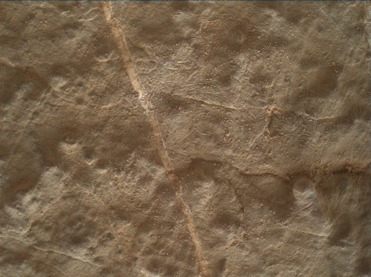
There were three options at the start of planning: (1) stay where we are and prepare to drill; (2) do a ‘bump’ to get into a better position to drill; and (3) a longer drive to find a better location. The issue with (1) was that, while the drive over the weekend left Curiosity in front of a very interesting outcrop, it also left the rover with significant tilt. So it was initially unclear whether we would pass the Slip Risk Assessment Process (SRAP), as required to be able to drill here. For this reason, both the GEO (geology) and ENV (environmental) science theme groups had to come up with a few different plans! Due to power and other constraints, the science block was only 37 minutes long, which didn’t leave enough time to do ChemCam activities as well as everything else. However, this location is of great interest for ChemCam because it’s close to the contact between the Greenheugh Pediment and Murray formation, hence chemical analysis could reveal important information on processes affecting the rocks immediately beneath Mount Sharp’s capping unit.

The ENV group and Mastcam therefore agreed to give up all of our activities to ChemCam if we were going to immediately drive away (option 3). If, however, we were going to stay put or ‘bump’ (options 1 and 2), we decided that ENV and Mastcam activities would take up all of the time, leaving the ChemCam activities until a later sol. Even then, the science activities varied depending on whether we stayed put or moved a little. For example, ENV dust devil movies are ideally taken during a period with REMS coverage, because we can then compare any imaged dust devils (dusty vortices) with measurements of vortex pressure drops made by REMS. The ‘stay put’ plan (option 1) had the science block at about 2pm local true solar time on Mars, which was covered by REMS; however, the ‘bump’ plan (option 2) had the science block earlier, during a period with no REMS coverage. So if we went with option 2, we would have pulled the dust devil movie to make room for other activities.

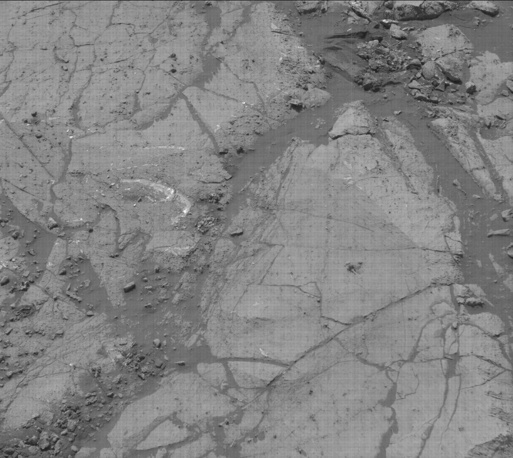
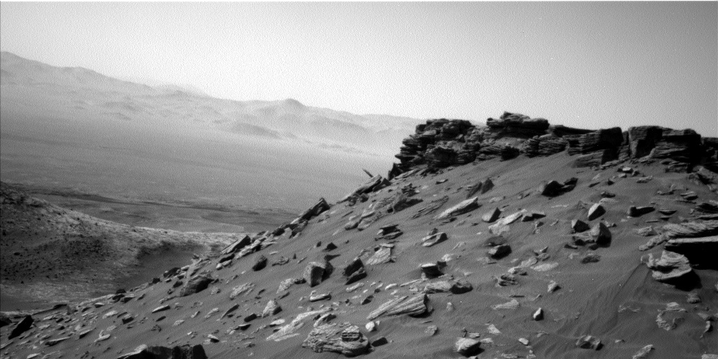
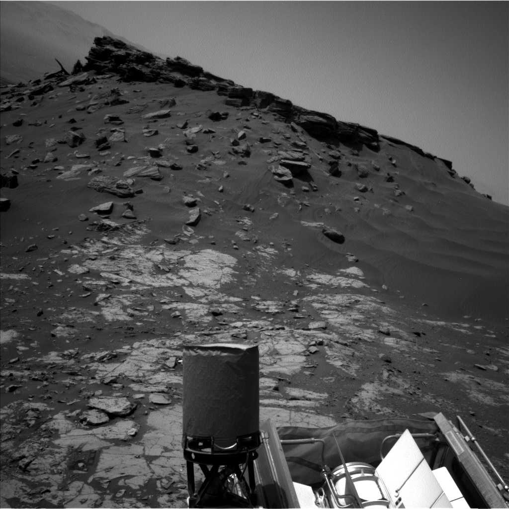
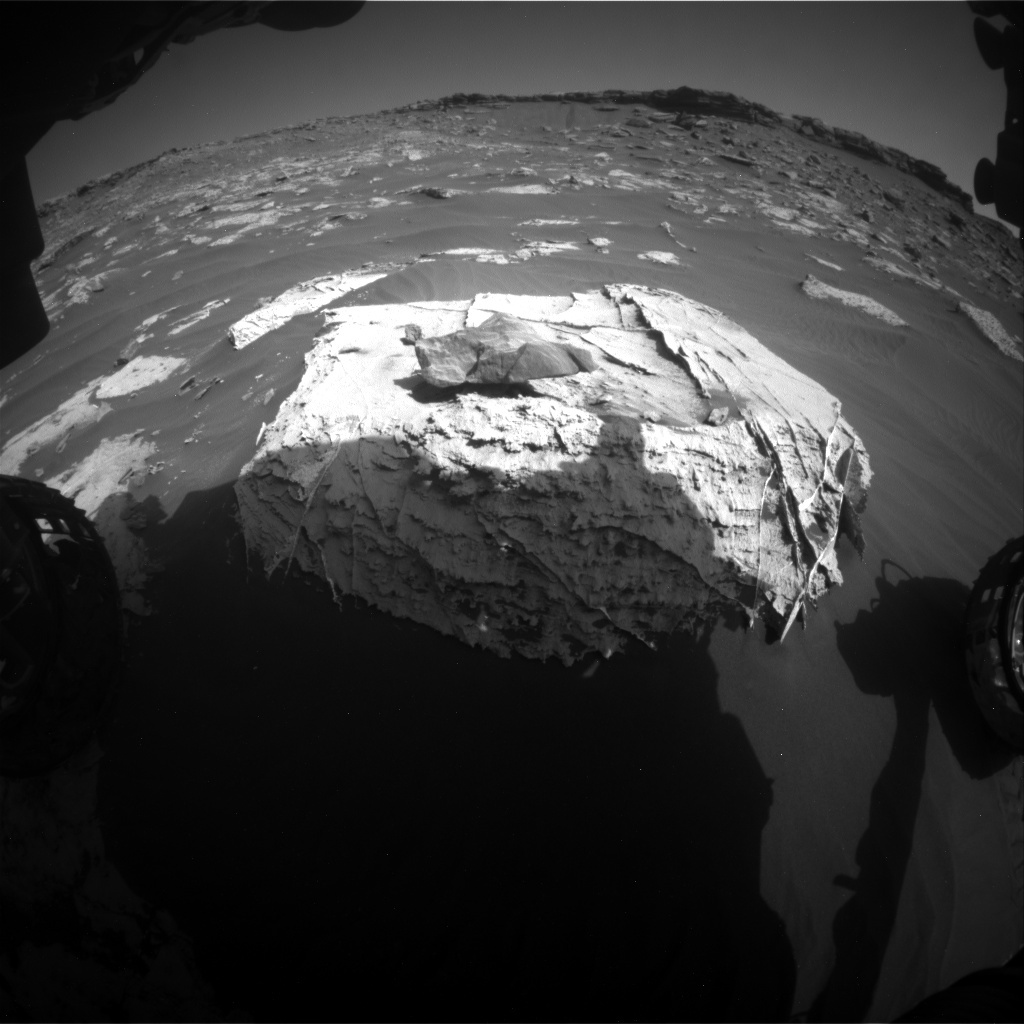
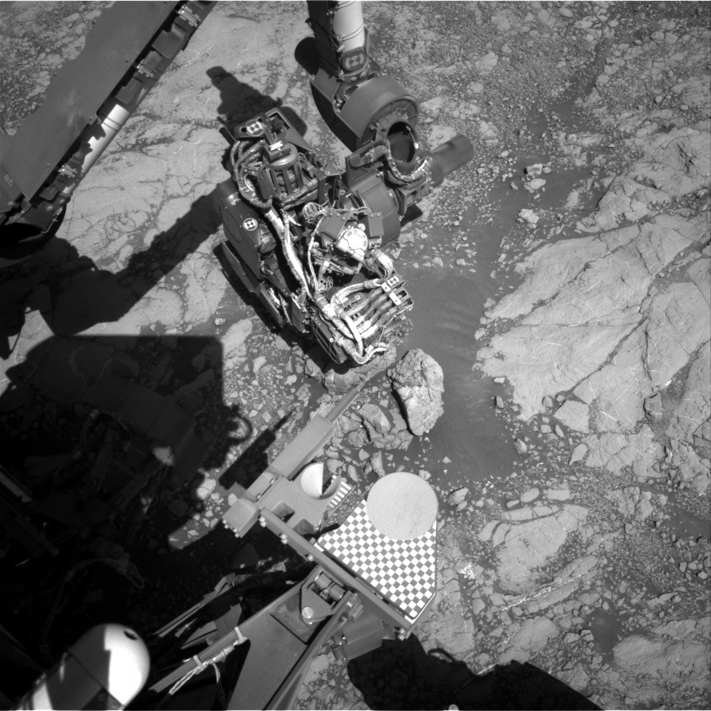
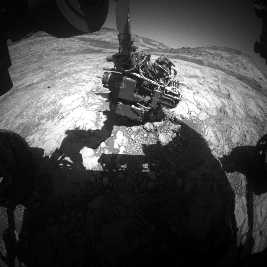
In the end, we discovered at the start of the SOWG meeting that the rover had passed SRAP and we would be staying put to drill (option 1). We therefore stuck with our bevy of ENV and GEO Mastcam activities. For ENV, these included a Suprahorizon cloud movie (looking for clouds above the north crater rim), a Navcam dust devil movie, and a Navcam ‘line of sight’ measurement of the dustiness across the crater. ENV activities were somewhat limited, as many of them rely on being able to image some distance away (e.g. to look for dust devils in all directions or to look for cloud shadows on Mount Sharp), whereas we are surrounded by high topography in many directions at this location (e.g. see image). For GEO, activities included APXS of the potential drill target “Hutton,” followed by a DRT (to remove dust) then a center and offset APXS on the potential drill spot, as well as a Mastcam mosaic of the top of “Tower Butte” to document sedimentologic structures, a Mastcam observation of a light-toned target named “Dumfriesshire,” and finally Mastcam on a on a portion of the bedrock that had been scuffed by the rover’s wheel, to look for surface changes. The latter will be used to infer wind strength and direction at our current location, which is valuable both for comparison with Mars atmospheric models and to determine the risk of drill samples being blown away.

February 3, 2020

Sol 2662-2664: Contact Science at a Record Setting Tilt

Written by Abigail Fraeman, Planetary Geologist at NASA's Jet Propulsion Laboratory
View of the martian terrain, tilted.

It’s not the ground that is tilted, we are! Image Credit: NASA/JPL-Caltech. Download image ›

Curiosity is near the contact between the clay-bearing “Glen Torridon” unit and the “Greenheugh” pediment, and the rover is parked at a mission-record setting 26.9˚ tilt! This weekend, we are going to use the rover’s arm and remote sensing instruments to investigate the interesting textures and chemistry of rocks near the contact. On the first sol of this weekend’s plan, we will use ChemCam to collect chemical information from a bedrock target filled with nodules called “Garron Point” and a dark float rock that may have come from the Greenheugh pediment named “Mull of Galloway.” We will also DRT and collect APXS, MAHLI, and ChemCam observations of “Berwickshire,” a typical-looking piece of bedrock. APXS and MAHLI will also observe “Cairnbulg,” an area with nodules, and MAHLI will take some images of a vein named “Ross and Cromarty.”

The second sol of the plan includes a Mastcam multispectral observation of Berwickshire and a stereo Mastcam mosaic of the contact between the Greenheugh pediment and Glen Torridon. ChemCam will collect more data from “Ramasaig,” a dark vein near the rover, and “St. Monanas,” another piece of rock with interesting textures. The rover will also acquire some environmental science observations that will be used to understand atmospheric properties and search for dust devils.

On the third sol of the plan, Curiosity will drive towards some flat rock outcrops that are nearby, but which the rover will be able to reach without having to park at such a high tilt. The observations we collect from this area next week will help us decide whether these flatter rocks would be a good target to drill!

January 30, 2020

Sols 2660-2661: A Geologic Six Pack

Written by Michelle Minitti, Planetary Geologist at Framework
Sols 2660-2661: A Geologic Six Pack

Yesterday’s drive successfully moved us uphill and closer to the “Greenheugh" pediment. The rocks around us were a riot of shapes, colors and textures, making it difficult to limit ourselves to which ones we would look at. The image above captures the six (yes, six!) targets we managed to fit in the plan today. The team is trying to understand how (or if) the bedrock chemistry changes as we move closer to the Greenheugh pediment, as the pediment marks a change in rock type from the majority of rocks we have encountered through the clay-bearing “Glen Torridon” unit. As such, many of our targets were dedicated to the bedrock today. MAHLI and APXS will analyze “Cullivoe” and “Bogmill Pow,” the former after it has been brushed by the DRT. Cullivoe represents the flatter, smoother areas of the bedrock free of veins or other erosion-resistant features while Bogmill Pow is one of the rough, multicolored areas of the bedrock. ChemCam will analyze a similarly complementary pair of targets. The goal is for “High Possil” to represent the background bedrock in this area, while “Duncairn” specifically focuses on an erosion-resistant feature that appears to be emerging from its host bedrock. Veins were a particularly spectacular feature of the workspace, often exhibiting white interiors and thin, gray exteriors. The most notable example is the bright, linear feature in the center of the image, given the name “Tilicoultry,” with a gray slab broken off and sitting on the sand to the right of the vein, named “Hastigrow.” This pair, and the bedrock and sand surrounding them, will be imaged using the Mastcam multispectral technique, which ought to help uncover the differences among the bedrock and the parts of the vein.

Curiosity will intersperse observations of the sky among all those of the ground. Mastcam will acquire early morning images to measure the dust load in the atmosphere, and Navcam will acquire late afternoon movies to look for clouds and dust devils. RAD and REMS maintain their steady watch of the weather and radiation environment in Gale, and DAN will seek signals of hydrogen from under the rover both before and after we drive. Yes, as hard as it will be to leave this spot, higher elevations call! We will drive to the highest accessible bedrock exposure just below the pediment in hopes that we can interrogate its chemistry over the weekend. Surely, more excitement awaits!

January 29, 2020

Sol 2659: Heading for the Bench!

Written by Catherine O'Connell
Front Hazcam image showing the bedrock target at the centre of today's plan.

Front Hazcam image showing the bedrock target at the centre of today's plan. Image credit: NASA/JPL-Caltech. Download image ›

Today the geology theme group (GEO) planned a single sol with a short science block (ChemCam and Mastcam) and contact science (APXS and MAHLI), followed by a drive towards the bench along the side of “Tower Butte.” The bench is an area that we are very interested in, as it marks a potential contact between the mudstones and sandstones that we have been driving over and a “capping” rock, which looks quite different. As we drive, we are looking for changes in chemistry and sedimentary processes, which can help us understand one of the big questions we are wrestling with right now: “Why are these buttes here?!!"

APXS and MAHLI are analyzing the bedrock target “Lost Valley,” (the larger block in the centre of the image above) whilst ChemCam and Mastcam are analyzing two other bedrock targets “Balantyre” and “Aberdeenshire.” Mastcam will also image a very intriguing rock “Hill of Stake” outside of the range of the other instruments, and further imaging of the “Greenheugh” pediment, which we hope to climb onto before this year is out.

Once these activities are complete, we start to climb further up the hill towards Tower Butte, hoping to end up with more bedrock in our workspace for a more complete compositional picture.

The environmental theme group (ENV) crammed activities into this short sol too, including “full tau” and “crater rim” observations, which allows the ENV group to quantify dust in the crater and overhead in the atmosphere. REMS will acquire temperature, pressure, humidity, and UV radiation measurements. DAN continues its search for subsurface hydrogen, with frequent passive (utilizing cosmic rays as a source of neutrons to measure hydrogen) and post-drive active (actively shooting neutrons from the rover) measurements.

January 28, 2020

Sol 2658: Touch and Go

Written by Ken Herkenhoff, Planetary Geologist at USGS Astrogeology Science Center
Sol 2658: Touch and Go

The Sol 2657 drive went well, so we have new bedrock exposures to explore on Sol 2658. The goal for today is to get good chemical and remote sensing data in this location before proceeding uphill toward the south. A "touch-and-go" sol is planned, starting with a short APXS integration on a bedrock slab named "Marchmont." MAHLI will take some images of Marchmont, then the arm will be moved out of the way for ChemCam observations of Marchmont and "Inverness Shire," a darker block sitting on the bedrock surface. Right Mastcam will then take images of the ChemCam targets and "Whitelaw Moss," another slab of bedrock. Mastcam will also acquire a 13x3 stereo mosaic of the west side of Tower Butte to examine its sedimentary structures. After a 23-meter drive and the usual post-drive activities, ChemCam will use AEGIS to automatically select a bedrock target in the rover's new location. Finally, MARDI will take an image during twilight. The tactical planning team did a great job, which made for an easy day for me as SOWG Chair.

January 27, 2020

Sols 2656-2657: Rover Activity Planning "Gaming" Finesse

Written by Susanne Schwenzer, Planetary Geologist at The Open University
MAHLI image featuring bedrock and veins. This image was taken by MAHLI onboard NASA's Mars rover Curiosity on Sol 2654 (2020-01-24T01:51:11.000Z).

MAHLI image featuring bedrock and veins. This image was taken by MAHLI onboard NASA's Mars rover Curiosity on Sol 2654 (2020-01-24T01:51:11.000Z). Image credit: NASA/JPL-Caltech/MSSS. Download image ›

Curiosity continues to function normally on Mars. We are at a very interesting point with potential changes in rock chemistry. That always gets the geochemists like me to sit up and pay extra attention. But we don’t always get it our way, because other investigations are just as important. Today’s plan is a two-sol plan with the third day being a soliday, which did not make it any easier. As the Science Operations Working Group chair put it: “This plan is a two-sol plan, but it surely doesn’t feel like it with all the details!” So, we waited anxiously for the plan to be combined from all the fragments and get the engineering judgement on power. Unfortunately, and despite serious efforts that reminded me of trying to play Tetris and Sudoku in the same game, the power available was not enough to get it all done. In a case like this, careful considerations are required regarding what observations are specific to the location or the time, and which ones could wait for the next plan. It was the ENV group, who today gave up an observation to make it all fit, but retains the crater rim extinction and the full tau observation.

From a geochemist’s perspective the most interesting part of the story at the current location is that we see two different types of bedrock. One is characterized in the images by a smoother appearance and veins in it. This type is the primary focus on the plan. But there is nodular bedrock, too. APXS has the smoother bedrock in reach and will measure the target “Rannoch Moore” as an evening investigation and “Sauchiehall” as an overnight, long duration target after DRT. MAHLI will document both targets. ChemCam will investigate “Rannoch Moore” in conjunction with APXS, and has the targets “Janetstown,” also on smoother bedrock, and “Glenalmond” on the nodular version.

At our current location, we have an excellent view of several buttes and the Geenheugh pediment. This is reflected in a very busy plan for Mastcam. The Greenheugh pediment and Tower Butte are images together in a 19x4 mosaic, but there are two more observations with mosaics on Western Butte and the trough feature in front of us. This will allow for detailed analysis of the sediments, but also aid the upcoming drives. Exciting times at a very interesting location!

ENV’s activity is a sunset tau, and MARDI, DAN and REMS measurements as well as post-drive imaging complete this very busy plan. In addition to all the observations, Curiosity is set to drive 50 metres – uphill! I am sure Curiosity is happy and ready for a recharging soliday after this plan!

January 21, 2020

Sols 2653-2655: Attitude Adjustment

Written by Scott Guzewich, Atmospheric Scientist at NASA's Goddard Space Flight Center
Curiosity's arm and Mars surface

Image of the rover's arm taken over the weekend. Image credit: NASA/JPL-Caltech

Last Friday’s plan was designed to ensure Curiosity had enough knowledge of its orientation to proceed with arm activities and mobility.

We learned this morning that plan was successful and Curiosity was ready for science once more!

And a very full science plan was made! Much of today’s plan was recycled from last Friday’s intended plan, including contact science with APXS and MAHLI on bedrock targets Moffat Hills and Trossachs. There also was a plethora of ChemCam LIBS targets, a Mastcam mosaic of Western Butte, Mastcam multispectral images on Trossachs, and ENV movies to search for clouds and dust devils while also documenting atmospheric dust levels.

Today’s plan also included a rare measurement with APXS to measure the argon abundance in the atmosphere.

Approximately 25% of Mars’ carbon dioxide-rich atmosphere condenses on the winter polar ice cap, while trace gases like argon do not. This leads to seasonal variations in the relative fraction of argon to carbon dioxide in the air. APXS can measure this argon variation by simply turning on and looking at the sky while the arm is stowed. Seeing argon vary through the year is akin to watching Mars breathe!

January 20, 2020

Sols 2649-2652: Curiosity Loses Its Attitude

Written by Dawn Sumner, Planetary Geologist at University of California Davis
This Hazcam image shows Curiosity's arm extended out to perform an APXS analysis of the bedrock. Curiosity has to know the exact angle of every joint to move safely.

This Hazcam image shows Curiosity's arm extended out to perform an APXS analysis of the bedrock. Curiosity has to know the exact angle of every joint to move safely. Credit: NASA/JPL-Caltech

Knowing where our bodies are helps us move through the world. We know if we are standing or sitting, if our arms are out or by our sides (or for some people, not there at all). This body awareness is essential for staying safe.

Rovers also need to know where their bodies are relative to their surroundings. Curiosity stores its body attitude in memory, things like the orientation of each joint, which instrument on the end of its arm is pointing down, and how close APXS is to the ground. It also stores its knowledge of the environment, things like how steep the slope is, where the big rocks are, and where the bedrock sticks out in a dangerous way. Curiosity evaluates this information before any motor is activated to make sure the movement can be executed safely. When the answer is no - or even maybe not - Curiosity stops without turning the motor. This conservative approach helps keep Curiosity from hitting its arm on rocks, driving over something dangerous, or pointing an unprotected camera at the sun. These safety checks require an accurate knowledge of the rover position within its environment and are an essential part of good engineering practice. They have kept Curiosity safe over the years.

Partway through its last set of activities, Curiosity lost its orientation. Some knowledge of its attitude was not quite right, so it couldn't make the essential safety evaluation. Thus, Curiosity stopped moving, freezing in place until its knowledge of its orientation can be recovered. Curiosity kept sending us information, so we know what happened and can develop a recovery plan. That is exactly what we did today: The engineers on the team built a plan to inform Curiosity of its attitude and to confirm what happened. We want Curiosity to recover its ability to make its safety checks, and we also want to know if there is anything we can do to prevent a similar problem in the future. This approach helps keep our rover safe.

January 13, 2020

Sols 2645-2646: A Strange Trough on Western Butte

Written by Melissa Rice, Planetary Geologist at Western Washington University
Sols 2645-2646: A Strange Trough on Western Butte

While descending from Western Butte, Curiosity has stopped to investigate a strange trough along the way. In the images from orbit, it looks like someone drew a thick straight line with a dark felt marker on the southeastern side of the butte. From the ground, it looks like a shallow ditch filled with dark sand. We don’t know what created this feature, or why it happens to be right here, so it’s worth stopping for a closer look.

Over the weekend (Sols 2642-2644), Curiosity drove downhill and parked at the top of the trough, which we named “Balgy.” The main event in today’s plan (Sols 2645-2646) is a large Mastcam stereo mosaic covering both sides of Balgy Trough. We’ll also take a smaller Mastcam stereo mosaic of laminated rocks nearby called “Baljaffray,” and grab a quick set of MAHLI and APXS observations on the bedrock target “Kennedys Pass.” After that, Curiosity will finish descending from Western Butte and will head south.