July 15, 2020

Sols 2824-2825: Drive for Science!

Written by Sean Czarnecki, Planetary Geologist at Arizona State University
Surface of Mars

This image was taken by Mast Camera (Mastcam) onboard NASA's Mars rover Curiosity on Sol 2820. Credits: NASA/JPL-Caltech/MSSS. Download image ›​

Curiosity continues its cross-country trek today, looking for our next drill site. Today's plan includes a long drive that should put us within view of potential drill targets. It is hoped that the region we are driving to will be a good opportunity to sample the clay-rich rocks of Glen Torridon one last time.

Of course we are still filling in some science observations around the long drive. Before driving, we will have ChemCam observations of targets "Tollcross" and "Sasainn" as well as a Mastcam image mosaic of target "Thirl Moor." After the long drive, we will have untargeted ChemCam observations of two additional targets, a DAN active measurement, and Navcam will look for clouds and dust devils. DAN, REMS, and RAD will work overtime making environmental observations before, during, and after the drive.

July 14, 2020

Sols 2822-2823: The Wheels Keep Turning

Written by Mariah Baker, Planetary Geologist at Center for Earth & Planetary Studies, Smithsonian National Air & Space Museum
surface of mars

Navcam image showing today’s workspace (Sol 2821). Credits: NASA/JPL-Caltech. Download image ›​

Today the rover continues to drive towards our next potential drill location, the first planned pit stop on our summer road trip. By the time Curiosity arrives at the designated drill area, she will have travelled over 23 km since landing on Mars. But driving across the rocky Martian surface isn’t always easy; sharp obstacles and jagged rocks have caused some minor damage to the rover’s wheels over the years. In order to check on the condition of the wheels and track their degradation over time, the team periodically images them with the MAHLI camera. As it happens, we are due for a new set of wheel images, so today’s “drive” is a bit unique: the rover will only travel a little over a meter, just enough to image one full rotation of the wheels.

Before this unusually short drive, the rover will acquire data on the local geology; bedrock targets “Cateran Trail” and “Cowal Way” will be targeted with the ChemCam instrument and imaged with Mastcam for documentation purposes. Mastcam will also capture stereo mosaics of nearby features of interest named “Fife Coastal Path” (a rock fracture) and “Glenfinnan Viaduct” (tilted rocks). Navcam will also be used to image sediment that has accumulated on the rover deck. After the wheel imaging, standard post-drive images will be acquired with Hazcam, Navcam, and Mastcam. There will also be two ChemCam AEGIS observations and two larger Mastcam mosaics, one of our target drill area and one of a more distant geologic contact. Lastly, three observations (two with Navcam and one with Mastcam) will be used to monitor dust activity in Gale crater.

Although our wheels have suffered some damage over the years, they’re still very capable of taking us where we need to go and we continue to make good progress on our strategic path. We expect to arrive at our designated drill location by the weekend, and we will be back on the road once our drill is complete!

July 10, 2020

Sols 2819-2821: Movin' Right Along in Search of Good Sights and Good Rocks

Written by Abigail Fraeman, Planetary Geologist at NASA's Jet Propulsion Laboratory
surface of Mars

This image was taken by Left Navigation Camera onboard NASA's Mars rover Curiosity on Sol 2817. Credits: NASA/JPL-Caltech. Download image ›​

On Wednesday, Curiosity successfully drove a whopping 102.5 meters over 159 minutes. This isn’t the longest drive Curiosity’s ever completed (the record is 142.5 meters on sol 665), but it did set a record for the longest drive ever planned from our quarantined dining room tables and couches. We’re making great progress on our summer road trip towards the sulfate unit, and are getting very close to our first “rest stop.” While I have fond memories of pulling over at the Delaware House during my many trips up and down the east coast of the U.S. as a child, Curiosity’s rest stop will be a location in the clay unit that we might decide to drill in order to collect one last clay-rich sample we leave the area.

We didn’t plan quite as long of a drive during planning today because of the visibility and types of terrain we’re in, but we do plan to drive another ~32 meters on the second sol of the weekend’s plan. Before that, we’ll collect ChemCam observations on targets named “Reivers Route,” “Moray Coastal Trail,” and “West Highland Way,” and take some Mastcam mosaics. We will also collect APXS and MAHLI data from a target named “Kintyre Way,” which is one of the larger rocks in the pebbly workspace in front of the rover today. Can you figure out the theme we used in selecting our target names today? Finally, Curiosity will collect the usual suite of observations to measure the environmental conditions, and image the ChemCam calibration targets after the drive on the third sol of the weekend plan.

July 8, 2020

Sols 2817-2818: Curiosity is Going Downhill

Written by Roger Wiens, Geochemist at Los Alamos National Laboratory
surface of Mars

This image was taken by Mast Camera (Mastcam) onboard NASA's Mars rover Curiosity on Sol 2813. Credits: NASA/JPL-Caltech. Download image ›​

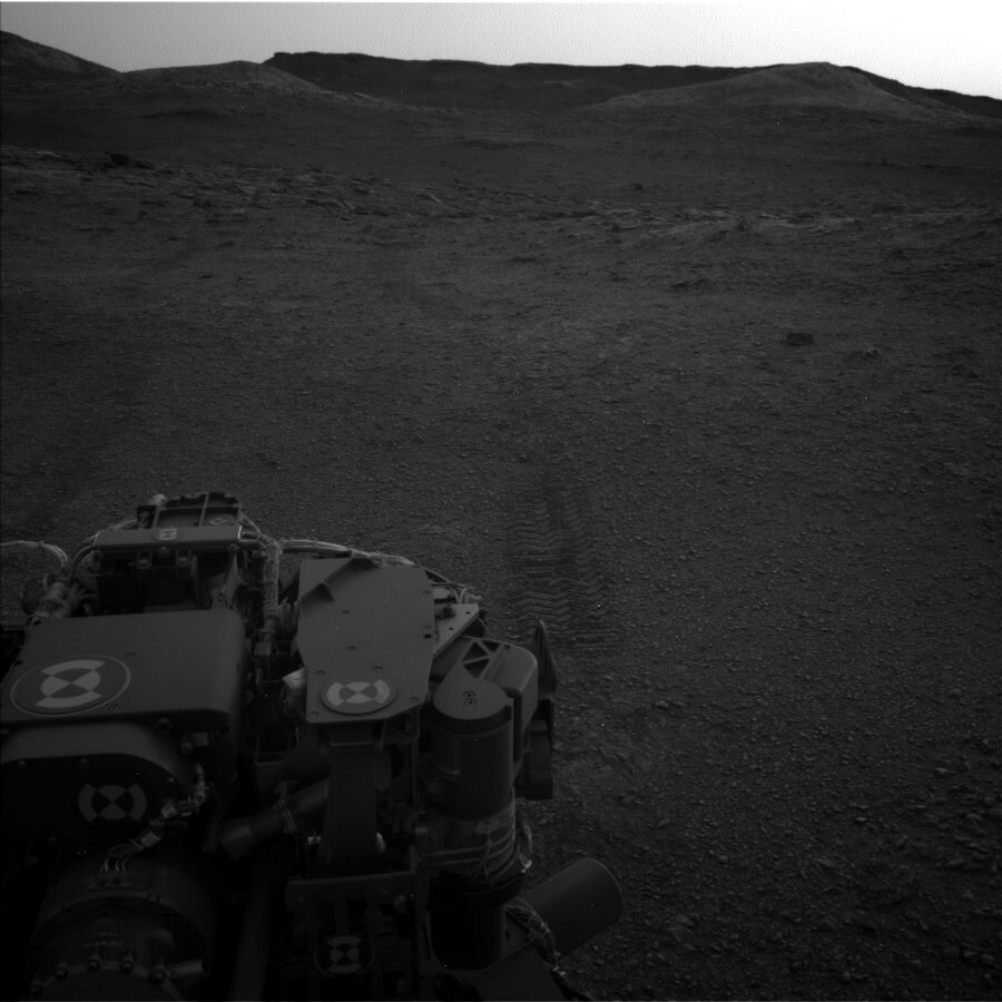
Curiosity is going downhill. Not in the figurative sense—Curiosity’s 10 instruments all still work well, its six wheels are all doing well, and the drill has been working great for the last two years as well as earlier in the mission. Okay, the rover’s power output is somewhat lower than when it started but, all in all, Curiosity is doing great. No, Curiosity is just heading to a slightly lower elevation, to look for a location to potentially drill at least one more sample in the clay unit. Clay beds tend to signal habitable environments where water was present for a long time and they also tend to be good at preserving organic materials. This drive is part of our “summer road trip” towards the sulfate unit, and will allow the team to potentially get another sample of the clay-rich region while Curiosity still has the opportunity (no pun intended).

Because Curiosity’s route has generally ascended Mt. Sharp, downhill drives of this magnitude have been rare. A little over two years ago Curiosity drove back down the front (north) side of “Vera Rubin ridge” (VRR) to pick up a drill sample of the “Blunts Point” member of the “Murray formation.” Early in 2019, Curiosity drove down the back (south) side of VRR into the clay unit, which is a slight depression in the side of Mt. Sharp. And more recently, Curiosity has driven down from some buttes and down from a short excursion on “Greenheugh Pediment.” Other than that, Curiosity has been climbing most of the time.

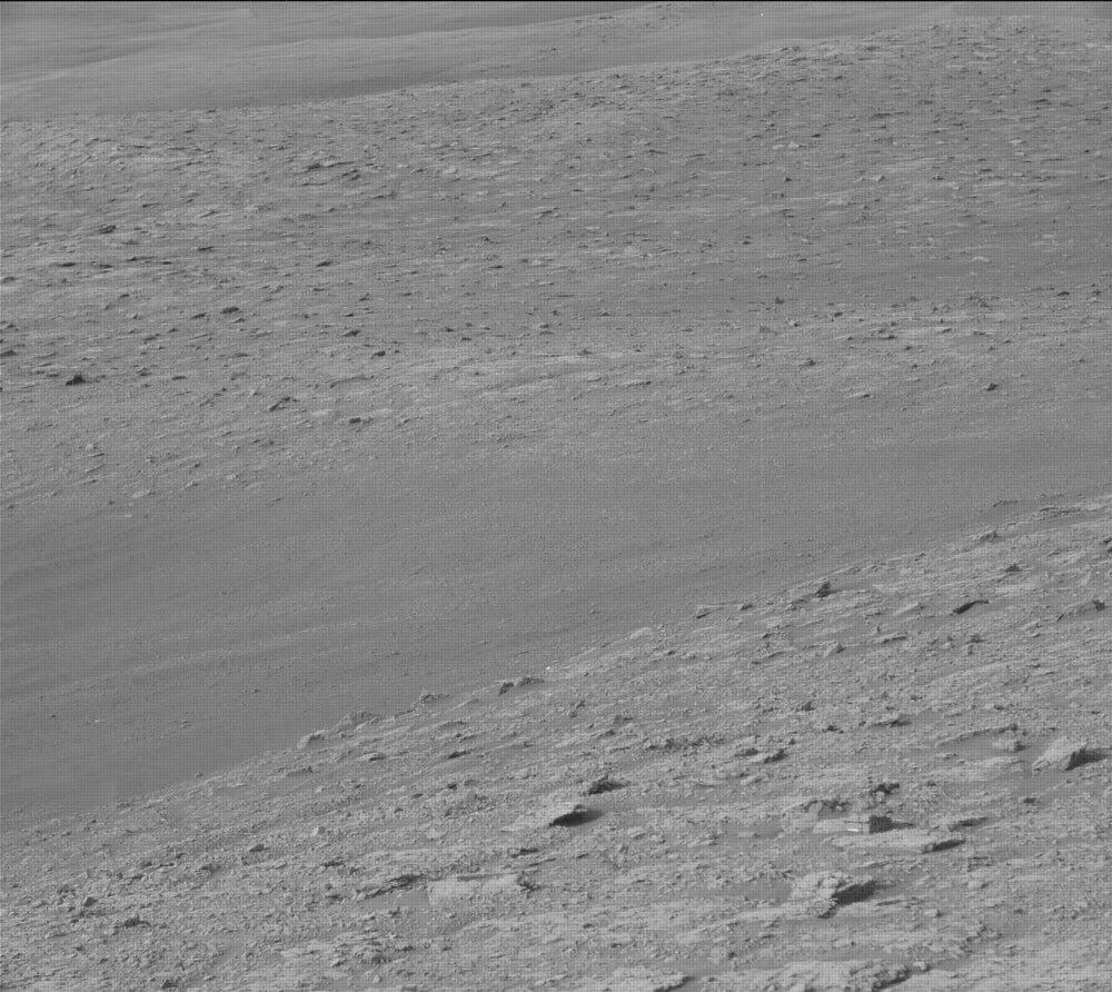
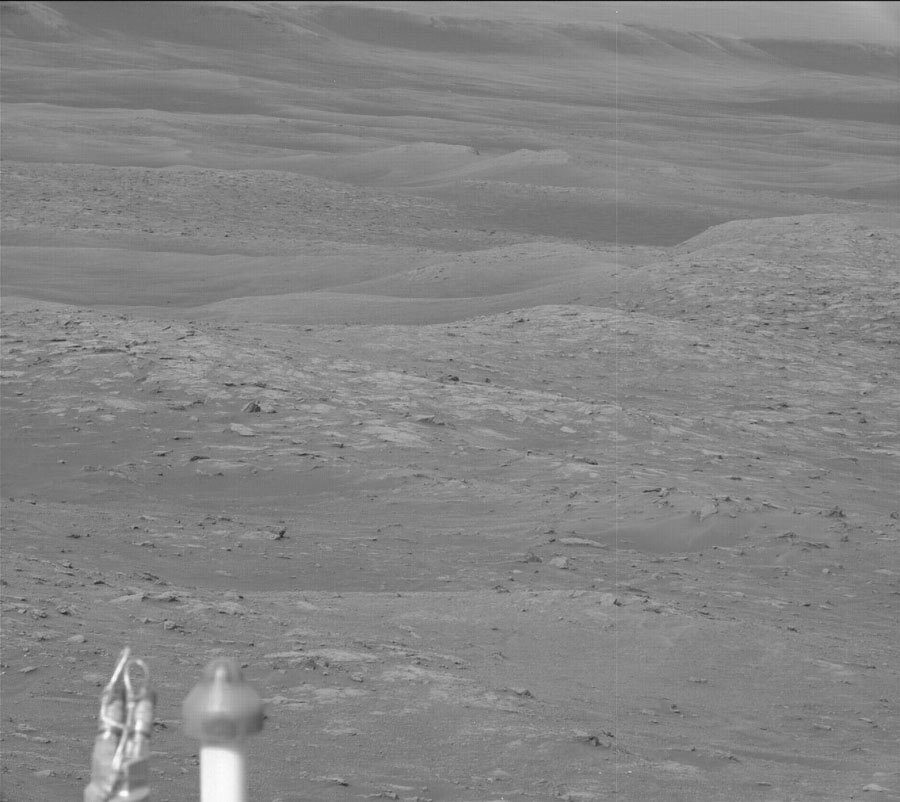
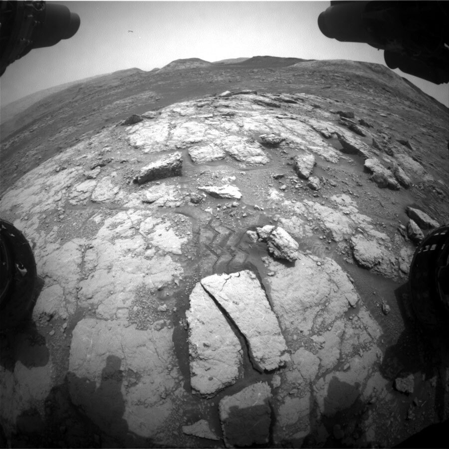
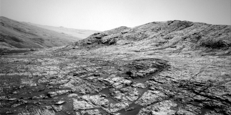
In the last several sols, Curiosity has already descended about 16 meters in elevation from its earlier perch on “Bloodstone Hill.” The accompanying image shows the view looking downhill across the clay unit, with VRR in the background.

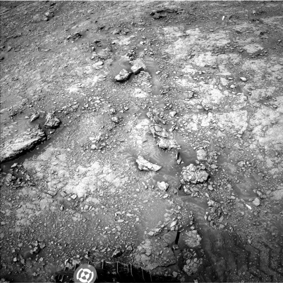
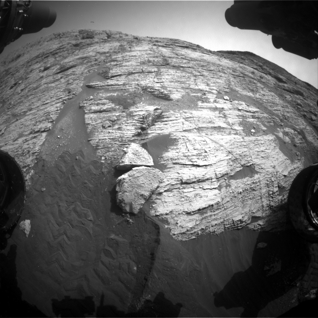
In this uplink plan Curiosity will do several observations at its current location, then do a relatively long drive on the second sol, followed by additional observation activities. ChemCam and Mastcam will make observations of bedrock targets “Caldback” (rubbly textured) and “Portencross” (smooth). Mastcam will also take stereo images of pebbles and of “Windy Gyle,” an outcrop to the east. Curiosity will then take its drive (hoping to go a distance of over 100 meters) combining an initial drive on terrain we can see with autonomous driving in the later part on terrain we haven’t yet imaged. The drive will be followed by a Sun tau observation by Mastcam and by post-drive image documentation. MARDI will take an image of the ground at twilight.

On the second sol, ChemCam will make a passive observation of the sky to measure its dust and water-vapor content, and will make an observation of a bedrock target selected autonomously by the rover. RAD, REMS, and DAN will continue taking data. Navcam will take a suprahorizon movie, and Mastcam will take another Sun tau measurement to check atmospheric dust.

July 7, 2020

Sol 2816: Curiosity Takes a Turn... to the North

Written by Lucy Thompson, Planetary Geologist at University of New Brunswick
Bow Fiddle block on Mars

Front Hazard camera image of the Sol 2816 workspace. “Bow Fiddle” is the block with the exposed vertical face slightly up and left from the centre of the image. Credits: NASA/JPL-Caltech. Download image ›​

We returned to nominal planning this morning after successfully upgrading Curiosity’s flight software. The drive today should take Curiosity a little to the north and east, towards our first planned stop on our summer road-trip to the sulfate-bearing unit. In order to preserve as much drive time and distance as possible, we kept the science activities relatively short and sweet.

Prior to the drive, Curiosity will acquire a ChemCam compositional analysis of the typical bedrock exposure in the workspace (“Bow Fiddle”), as well as two Mastcam mosaics of the eastern-most exposures of the Greenheugh Pediment, which we plan to visit later in the mission.

Following the drive, the ChemCam instrument will capture the chemistry of the rocks in the new workspace, using its autonomous targeting capabilities. The remaining post-drive science activities will be devoted primarily to environment and atmospheric monitoring, which are particularly important during Mars’ current dusty season. These will include a large Navcam dust devil survey, a Navcam deck survey, Mastcam full tau imaging towards the sun and a Mastcam sky survey.

A post-drive MARDI science block to monitor the ground beneath Curiosity’s wheels, as well as standard REMS, RAD and DAN activities round out our return to nominal planning.

It has been a quiet day for me as the APXS strategic planner, as we maximize driving for distance on our summer road-trip. However, I am looking forward to Curiosity being able to stretch her arm over the weekend, to touch the rocks, and hopefully document the chemistry and textures with the contact science instruments (APXS and MAHLI).

July 1, 2020

Sols 2810-2815: No Holidays on Mars

Written by Scott Guzewich, Atmospheric Scientist at NASA's Goddard Space Flight Center
Surface of Mars

This image was taken by Rear Hazard Avoidance Camera (Rear Hazcam) onboard NASA's Mars rover Curiosity on Sol 2809. Credits: NASA/JPL-Caltech. Download image ›​

To give the (American) Earthlings a holiday on Friday, we planned 5 sols of activities for Curiosity today. But our rover will certainly not be taking any days off, with a mix of science and engineering activities over the long weekend. We are continuing to update the rover computer’s flight software, which will preclude nearly all science activities during the first and last sols of those 5 sols. In between is a fairly normal 3-sol weekend plan.

We started planning today with the realization that the rover had adjusted its position from the previous sol and the front left wheel moved downward onto the surface. This uncertainty in our position precluded contact science at this location, but GEO still scheduled a full list of remote sensing science with ChemCam and Mastcam before we drive away over the weekend.

Mars is in the middle of the dusty season currently (southern hemisphere spring) and the amount of dust in the atmosphere has been increasing over the last 2 weeks, although it is still within typical values for the season above Gale Crater. For the long weekend, I added several additional activities to the rover’s plan to monitor atmospheric dust devils so we’re aware if any storms develop.

June 26, 2020

Sols 2805-2809: Pit Stop for Curiosity

Written by Catherine O'Connell-Cooper, Planetary Geologist at University of New Brunswick
Bloodstone Hill on Mars

Front hazard (FHAZ) image from our current workspace, looking back up towards "Bloodstone Hill." Credits: NASA/JPL-Caltech. Download image ›​

We drove in our last plan, about 15 metres, ending up with some bedrock and sand in our workspace. Normally, Fridays are our busiest day in the geology theme group (GEO). We choose targets for contact science, with lots of back and forth between all the geochemistry, camera and engineering teams, to pick the best ones, while the environment theme group (ENV) plans a range of environmental activities.

Not this weekend though! Curiosity is taking some time to do routine software updates, so the next couple of plans will be concentrating on those, leaving not much room for anything else. ENV have planned REMS and RAD environmental monitoring activities, part of their ongoing daily activities.

We will still be here next week, and we’ll pick up our contact science at that point, in time for the July 4th U.S. holiday.

June 24, 2020

Sols 2803-2804: A Drive to a View

Written by Fred Calef, Planetary Geologist at NASA's Jet Propulsion Laboratory
Surface of Mars

"Bloodstone Hill" appears just to the right as well as numerous decimeter-scale bounders on the bumpy road ahead up Mt. Sharp. Credits: NASA/JPL-Caltech. Download image ›​

As much as the science team loves seeing Mars up close, sometimes the view isn't quite as pretty for the engineering team. As the rover gets closer to hills or cliffs, like "Bloodstone Hill" that we just left, we encounter boulders that have rolled downslope (as they are wont to do), creating visual obstacles in our path. It's also the case that sometimes Mars makes bouldery landscapes, like when we drove up towards Vera Rubin Ridge. The path ahead is very similar to that. Rover planners only want to drive where they can see in the navigation images from the Mars surface. The area that is visible from where you are is called a viewshed. You can imagine that for a big rock, if you're standing several meters away, you only see one side of it. For moving the rover, you don't want to "drive around a corner" and find yourself staring over a cliff, driving over pointy rocks, or ending up embedded in sand! Granted, we can see a lot of martian terrain from satellite imagery, but since there's no tow service or garages in Gale Crater, we have to be cautious. All that said, our next drive will be only about 15 meters, so we can get a better view for a longer drive in the next planning cycle.

On Sol 2803, we'll scope out some of the local bedrock at the outskirts of Bloodstone Hill with ChemCam on "Powburn," "Hunterian," 'Earl's Palace," and "Otterburn" with accompanying Mastcam images. The rover arm will be deployed to get some APXS chemistry, microscopic views with MAHLI, and Mastcam images on "Capercaillie," a rock with multiple layers. Despite not being able to see too far ahead, we'll still take some Mastcam mosaics of polygonally fractured bedrock and a look back at Bloodstone Hill. Environmental monitoring will include a line-of-sight view and dust devil search movie with Navcam. After a short drive on Sol 2805, we'll take some views ahead and do a Mastcam clast survey, looking at the pebbles on the ground.

Here's to an expansive view of the road ahead!

June 23, 2020

Sol 2802: Finishing Observations at 'Bloodstone Hill'

Written by Roger Wiens, Geochemist at Los Alamos National Laboratory
Surface of Mars

This image was taken by Right Navigation Camera onboard NASA's Mars rover Curiosity on Sol 2799. Credits: NASA/JPL-Caltech. Download image ›​

Last week while giving a talk on Mars, I was reminded of the times when, as a kid, I used to sketch the features of the Red Planet seen through a telescope in my back yard. It is possible to see some of those features (polar caps, darker and brighter albedo regions, and sometimes clouds) with a telescope having a mirror six inches (~150 mm) or larger in diameter. The features become obvious when the Earth passes Mars, as is happening this year.

Mars glob
Hubble Takes Mars Portrait Near Close Approach
Credits: NASA, ESA, Hubble Heritage Team (STScI/AURA), ASU, SSI
Full image and caption ›​
The closest approach will be in early October, when the Red Planet comes within 39 million miles (62 million kilometers) of Earth. Opposition—when Mars and the Sun are opposite each other from the Earth’s perspective—will occur just a little later, on the 13th of October. As this date approaches, Mars will appear to move quite rapidly against the background of stars from night to night. Right now, it is “moving” from Aquarius to Pisces, visible in the eastern sky in the early morning before dawn.

Back in Gale Crater, Curiosity is finishing its very brief investigation of “Bloodstone Hill.” It will start the day with documentation imaging by Hazcam and Navcam of the APXS overnight target, and stowing of the arm. That will be followed by Mastcam observations of “Chambers Street” and calibration targets. ChemCam and Mastcam will both make observations of “Skaw,” which is a rock that was scuffed by the rover wheel. Curiosity will then drive back downhill for a planned distance of ~60 m. There will be post-drive imaging by Navcam, looking at the rearward terrain and the rover deck. MARDI will take an image of the terrain below the rover after the drive. REMS, RAD, and DAN will also take data. With that, Curiosity should be back on the road (figuratively speaking) toward the sulfate unit.

June 22, 2020

Sol 2801: Keep Running Up That Hill?

Written by Scott Guzewich, Atmospheric Scientist at NASA's Goddard Space Flight Center
Surface of Mars

This image was taken by Front Hazard Avoidance Camera (Front Hazcam) onboard NASA's Mars rover Curiosity on Sol 2800. Credits: NASA/JPL-Caltech. Download image ›​

"Bloodstone Hill" continued to present a challenge to us over the weekend, when our second attempt to reach an ideal spot for contact science failed. The hill is steep and rocky, making it harder to gain traction. But ultimately, the sulfate unit is more of a priority to the science team, so we’ll be leaving Bloodstone Hill behind and continuing our journey. Today, the first discussion was weighing whether to try again or use the bedrock that was available in the current workspace for our contact science. After finding that our position was stable for contact science, GEO quickly identified a suitable location for analysis by APXS and MAHLI. Beyond the contact science, GEO has a busy plan with 3 ChemCam LIBS targets and a large Mastcam mosaic of the layers in Bloodstone Hill.

As ENV theme group lead today, I added a dust devil movie and two images of the crater rim to monitor dust in the atmosphere. We’re seeing lots of dust devil activity lately as we’re in the peak season for them on Mars and also seem to be near an area that is conducive for their formation.