May 26, 2021

Sol 3131: Recovering

Written by Ken Herkenhoff, Planetary Geologist at USGS Astrogeology Science Center
This image was taken by Right Navigation Camera onboard NASA's Mars rover Curiosity on Sol 3128.

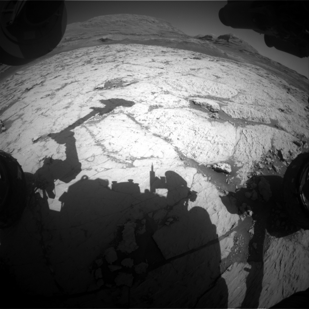
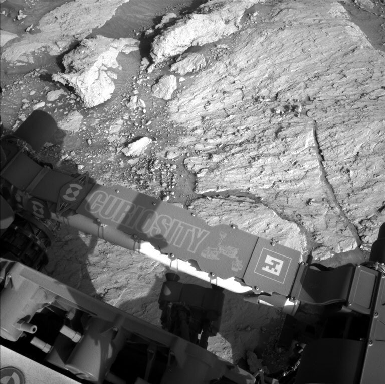
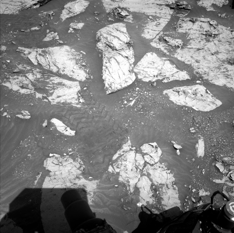
This image was taken by Right Navigation Camera onboard NASA's Mars rover Curiosity on Sol 3128. Credits: NASA/JPL-Caltech. Download image ›

The Sol 3131 plan is focused on recovering from recent anomalies: Engineers need a few additional sols to study the previous hiccup with the remote sensing mast (RSM). In addition, MAHLI's focus mechanism did not completely stow on Sol 3129, so both RSM and MAHLI activities are precluded in favor of diagnostic tests. These preclusions limited the new activities that could be planned today, so the rover will not be as busy as usual on Sol 3131, but we were still able to plan more environmental observations and contact science! During the day, the Front Hazcams will be used repeatedly to search for dust devils.The Navcams are pointed at the rover deck, so will also be used to watch for changes in the distribution of dark sand that was blown up onto the deck by winds. Arm motion is permitted, so after the MAHLI focus motor is driven to its "home" position, the DRT will brush off a bedrock target named "Festalemps" before the APXS is placed on another bedrock target "Villars" for an evening integration. Afterward, the APXS will be placed on the Festalemps brushed spot for an overnight integration. Early on the morning of Sol 3132, RSM diagnostic tests will be performed, at the same time of day that the stall occurred on Sol 3127. Hopefully these diagnostic tests will show that the RSM and MAHLI are healthy and ready for use!

May 24, 2021

Sols 3129-3130: A Familiar Scene

Written by Lauren Edgar, Planetary Geologist at USGS Astrogeology Science Center
This image was taken by Front Hazard Avoidance Camera (Front Hazcam) onboard NASA's Mars rover Curiosity on Sol 3127.

This image was taken by Front Hazard Avoidance Camera (Front Hazcam) onboard NASA's Mars rover Curiosity on Sol 3127. Credits: NASA/JPL-Caltech Download image ›

We started planning today hoping to see some new bedrock in our workspace, but unfortunately the weekend plan didn’t work out exactly as we had hoped. As the previous blog explained, we’re in the process of recovering from a fault with the MAHLI cover. The good news is that the MAHLI cover was successfully closed over the weekend, but we encountered some unrelated hiccups with Curiosity’s remote sensing mast, so we have limited science activities today. I was on duty as Long Term Planner (LTP) today, and all of these changes to the plan kept me on my toes. I’m impressed by how the team was able to quickly adapt to changing circumstances and add some helpful observations into the plan. We’ll mostly focus on environmental monitoring activities in today’s two-sol plan, with DAN and REMS and some Hazcam dust devil surveys. SAM also planned an electrical baseline test, which we periodically do to monitor instrument health. Looking ahead, we hope to drive later this week and get back on the road to explore the basal sulfate unit. The view might be familiar, but it’s still pretty spectacular - I love the above Hazcam image with the shadow of the arm outstretched and some tantalizing stratigraphy ahead!

May 21, 2021

Sol 3126-3128: The Fault in Our Startup Routine

Written by Scott Guzewich, Atmospheric Scientist at NASA's Goddard Space Flight Center
This image was taken by Chemistry & Camera (ChemCam) onboard NASA's Mars rover Curiosity on Sol 3124.

This image was taken by Chemistry & Camera (ChemCam) onboard NASA's Mars rover Curiosity on Sol 3124. Credits: NASA/JPL-Caltech/LANL. Download image ›

Our nearly nine year old rover occasionally has a hiccup and needs to reset and try again. This week, that happened with MAHLI and today we tried to recover those activities from earlier this week with contact science at “Festalemps” (a bedrock target for the dust removal tool and then APXS) and “Villars” (a textured rock target for APXS only). Once that is complete, along with some Mastcam imaging and ChemCam LIBS activity, we’ll drive away from this location.

We’re always looking ahead to our future activities and this plan is no exception as we’ll continue using ChemCam as a long distance spyglass for imaging the sulfate-rich geological unit (a portion of which is seen in this image) uphill from our current location.

This weekend will also continue a number of environmental science activities to search for clouds, measure the amount of dust in the atmosphere, and study the physical properties of dust particles through a Mastcam sky survey. We’re in the cloudy season on Mars currently, which will continue through the end of this (Earth) year. Martian clouds are very much like cirrus clouds here on Earth and are made of tiny water ice crystals.

May 19, 2021

Sol 3124-3125: Switch it off and on Again…

Written by Susanne Schwenzer, Planetary Geologist at The Open University
Curiosity took an image of the martian surface.

This image was taken by Left Navigation Camera onboard NASA's Mars rover Curiosity on Sol 3122. Credit: NASA/JPL-Caltech Download image ›

First things first, we had a few stubborn technical devices on Mars and Earth to contend with today. My planning day here on Earth started with a computer that wouldn’t react to anything just 3 minutes before I had to call in… While terrestrial computer problems are usually being solvable by switch it off and on again, recovering on Mars takes just a little longer. And back online I learned that recovering on Mars is what we have to do… The problem was a stubborn MAHLI cover. Consequently, the plan contains recovery activities to take an image of the cover. Diagnosing hiccups on Mars is not always as simple as ‘switch it off and on again,’ … but I am just a mineralogist, so I better leave that part to the engineers!

As before, if the rover finds itself on the same parking spot, the science team develops ideas what to do, and often those are building on the ideas developed in the last planning session, observations that came second in a close race to the front runner of the last plan, and new ideas from the data already received. Today was no exception, and the team managed to assemble an exciting set of observations that will tell us even more about the mineralogy and geochemistry of the location than we had hoped for.

Curiosity will perform one ChemCam active observation on the target “La Donzelle.” ChemCam is also busy with two long distance mosaics to image the fascinating landscape that the flanks of Mt Sharp offer. Mastcam is performing a 360 panorama, and targeted observations to better understand the landscape around us. On the mineralogy side, we will get a multispectral observation of the area shown in the image atop of this blog and towards the left of it. In addition, there are many atmospheric observations, with looking at the crater rim for opacity, doing a sky movie and watching out for dust devils; and the weather station is adding to these atmospheric observations, too. Inside the rover, CheMin is busy with housekeeping and data management, and DAN is getting data as well. Another busy day on Mars!

May 17, 2021

Sols 3122-3123: Smooth Planning, but Not the Rocks!

Written by Lucy Thompson, Planetary Geologist at University of New Brunswick
Close-up MAHI image taken from ~5 cm above the erosion-resistant target “Salagnac,” acquired in our previous workspace on Sol 3119. This was also an APXS target.

Close-up MAHI image taken from ~5 cm above the erosion-resistant target “Salagnac,” acquired in our previous workspace on Sol 3119. This was also an APXS target. Credits: NASA/JPL-Caltech/MSSS. Download image ›

In contrast to the last time I contributed a blog, today was a smooth planning session. Our weekend science activities and drive executed flawlessly and the workspace was dominated by bedrock. A significant proportion of the surface was rough-textured with small, wind-resistant knobs and bumps, as well as larger resistant areas associated with veins that cross-cut the bedrock. We have been seeing a lot of these more erosion-resistant features on and around Mont Mercou. We aim to utilize Curiosity’s instrument suite to fully characterize the smoother bedrock and resistant features as we continue to climb Mount Sharp and transition into the sulfate-bearing unit identified from orbit.

As the APXS strategic planner I was ready to suggest targets for investigation with our instrument (for composition) and for close-up imaging with MAHLI. We chose “Parcoul” a darker, resistant area associated with a vein. It will be interesting to see if it has the same composition as the recent bedrock, or if it appears to have been altered as a result of later fluid-flow associated with the vein. ChemCam will acquire a LIBS observation to determine the chemistry of the nearby bumpy bedrock target “Millevache” as a comparison.

In order to further document the workspace textures, Mastcam images of the targets “Millevache,” “Dussac” and “Doissat” will also be acquired. Before driving away from this location (~40 m), ChemCam will also image the more distant “Thonac” target with its RMI to look for layering, textures and sedimentary structures associated with this butte, forming part of the sulfate-bearing unit.

After the drive, Curiosity will take the standard suite of images to document the new workspace and drive direction, as well as a MARDI image of the terrain immediately beneath the rover wheels. Environmental monitoring will include taking Navcam images to monitor dust activity in the atmosphere and to investigate dust devil activity. Standard RAD, REMS and DAN activities round out this plan.

A final note, welcome to Mars Zhurong! Wishing you relatively smooth and successful roving!

May 14, 2021

Sols 3119-3121: A Full Weekend Plan

Written by Ken Herkenhoff, Planetary Geologist at USGS Astrogeology Science Center
parts of Curiosity are visible in this image of Mars

This image was taken by Left Navigation Camera onboard NASA's Mars rover Curiosity on Sol 3117. Credit: NASA/JPL-Caltech. Download image ›

There is lots of bedrock in the arm workspace in front of the rover, and contact science targets were quickly selected this morning. The 3-sol weekend plan includes lots of interesting observations of the arm workspace and more distant targets, plus a 35-meter drive, so we had to work harder than usual to make sure that we leave enough energy in the battery to enable the next plan. This made planning a bit more stressful than usual for me as Science Operations Working Group Chair, but all ended well and I'm looking forward to seeing the results!

On Sol 3119, Navcam will search for clouds before Mastcam gets to work acquiring stereo mosaics of targets "Allas les Mines," "Agonac," "Ballerand," "Badefols," and some grey stones on the flank of Mt. Sharp. ChemCam will then fire its laser at a bedrock target called "Monsec" and take a 7x2 RMI mosaic of a distant ridge before Mastcam takes a 4x4 stereo mosaic of the bedrock surrounding Monsec. Later that afternoon, the arm work begins with MAHLI imaging of Monsec before and after it is brushed by the DRT. MAHLI will also take pictures of "Salagnac," a nearby bedrock target that will be measured by the APXS after sunset. APXS will also perform an overnight integration on Monsec. The APXS and ChemCam LIBS observations are intended to detect changes in the chemistry of the bedrock as we continue the traverse into the sulfate-rich materials discovered using orbital data.

The arm will be retracted on the next sol, allowing Mastcam multispectral and ChemCam passive observations of the brushed Monsec spot. Then the drive will begin. Because there is a ridge about 8 meters in front of the rover that blocks visibility of the terrain beyond, the rover will drive directly to the top of the ridge, then use the "guarded" driving mode to continue past the ridge, to a location that should allow better visibility of the path ahead. The guarded driving mode is a type of autonomous driving mode that has not been used very often lately to reduce wheel wear, but based on orbital images the bedrock is fairly smooth ahead, so it should be safe to let Curiosity check for hazards itself. Afterward, MARDI will take their standard twilight image.

May 13, 2021

Sols 3117-3118: An Abundance of Diagenetic

Written by Kristen Bennett, Planetary Geologist at USGS Astrogeology Science Center
diagenetic features on Mars

Diagenetic features are visible in this image taken by the Chemistry & Camera (ChemCam) onboard NASA's Mars rover Curiosity on Sol 3115. Credit: NASA/JPL-Caltech/LANL. Download image ›

Today Curiosity is finishing up at a stop designed to investigate diagenetic features—features that formed after the sediment first was deposited—such as veins and color variations within the bedrock. One of these fantastic diagenetic features is shown in the image above, which ChemCam imaged in Monday’s plan. Today’s plan is full of remote science and contact science before the rover drives away to continue traveling towards the sulfate unit.

Veins are abundant in this workspace, and APXS and MAHLI will target a bright white vein near the rover that is called “Busserolles.” ChemCam has a LIBS target on “Quinsac,” which APXS and MAHLI investigated in Monday’s plan. ChemCam will also target the feature “Razac de Saussignac” as a passive observation. Razac de Saussignac is a fresh rock face with interesting color variations that was broken by the wheel when Curiosity drove over it on the previous drive.

The plan also includes a Mastcam mosaic of “Belves” to investigate the stability of the rocks in the Mt. Mercou cliff face and a ChemCam long distance RMI to target potential bedding within the sulfate unit.

After the drive, MARDI will take a twilight image and there will be several atmospheric observations including a dust devil survey and a cloud observation.

May 11, 2021

Sols 3115-3116: Revealing Mars' True Stripes

Written by Mariah Baker, Planetary Geologist at Center for Earth & Planetary Studies, Smithsonian National Air & Space Museum
Rocks on Mars seen by Curiosity rover

This image, taken by the Mast Camera (Mastcam) onboard NASA's Mars rover Curiosity on Sol 3085, shows the two-toned vein in today’s workspace. Contact science targets "Biras" and "Quinsac" were selected on this exposed vein. Credit: NASA/JPL-Caltech/MSSS. Download image ›

Today the team was greeted by a new workspace that included “tiger striped” rocks and an intriguing two-toned vein (shown in the Mastcam image above). One of the team’s main goals for today was to collect as much data as possible on these striped rocks and on the protruding veins that create the rocks’ distinctive appearance. The data we collect will help us interpret these unique geologic features and decipher how they relate to the long-term history of Gale crater.

During today’s planning session, the team scheduled two sols of rover activities for our new workspace. The first science block on sol 3115 will include a ChemCam RMI mosaic of a distant, uncharacteristically “dark” geologic unit and a Mastcam stereo mosaic of vein-filled rocks “La Couze.” Bedrock target “Coly” will also be analyzed with a Mastcam multispectral observation and a ChemCam LIBS observation. Three Navcam atmospheric observations were planned for the science block on sol 3116: a “line of sight” dust characterization image, a suprahorizon cloud movie, and a dust devil survey. The second science block will also include a ChemCam passive observation and a Mastcam documentation image on target “Excideuil.”

Standard REMS and DAN measurements were also planned for both sols to help monitor environmental conditions. Last but not least, APXS and MAHLI measurements on targets “Biras” and “Quinsac” will provide useful information on the material within the two-toned veins and striped rocks that typify this area. The team is excited to collect and analyze these new data to see what they can reveal about ancient Mars.

May 7, 2021

Sols 3112-3114: Always a Silver Lining!

Written by Catherine O'Connell-Cooper, Planetary Geologist at University of New Brunswick
MAHLI image, showing a closeup of the “Gourdon” target, taken from a standoff of 3.5 cm.

MAHLI image, showing a closeup of the “Gourdon” target, taken from a standoff of 3.5 cm. This image was taken by the Mars Hand Lens Imager (MAHLI), located on the turret at the end of the rover's robotic arm, on May 6, 2021, Sol 3110. Credit: NASA/JPL-Caltech/MSSS. Download image ›

Things not going to plan doesn’t have to mean a disaster - sometimes there is a silver lining to be found and today was one of those days.

We had planned to drive a couple of metres in our last plan, but Curiosity pulled the drive up short after less than half a metre when autonomous sensors showed the terrain was a bit trickier than expected so the rover stopped to ask for more instructions from Earth. Getting off the edge of Mont Mercou is testing our driving abilities, with some steep and tricky terrain, but our fantastic engineers and rover planners (“RP”) are stubborn! Just picture them rolling up their sleeves, in home offices in living rooms and basements around the country and getting challenged by planning across this tough terrain. They have their work cut out for them – and that is before the geology theme group (GEO) takes a look at the images and picks out targets that are interesting to us, but which can also prove challenging for the arm engineers to safely reach with the APXS and MAHLI instruments!

In this case, the drive stopping short worked in GEOs’ favour. MAHLI imaging of an APXS target on freshly broken rock (as the rover drove over it) from Wednesday (“Gourdon”) revealed very intriguing textures. From this slightly different angle, we were able to get both Mastcam multispectral imaging and ChemCam on a section of this target (at “Grignols”) in today’s plan – an opportunity we would have missed if the drive had gone as planned. APXS, MAHLI and ChemCam were also able to analyze more of these beautiful veins (“Pezuls”) and unusual, rough and twisted textures (“Le Bugue” and “Grives”).

Our stalled drive also provided an opportunity for bonus multispectral imaging of the workspace we had been aiming for – this time in the Mastcam target “Mayac” which includes the “tiger stripe” rock that we are itching to analyze! We hope to end up here for Monday’s contact science, so extra imaging will be very useful in picking targets of interest. Looking forward to finally getting to the “tiger stripe” rock!

May 5, 2021

Sols 3110-3111: A New Workspace!

Written by Abigail Fraeman, Planetary Geologist at NASA's Jet Propulsion Laboratory
A black and white view of Mars

This image was taken by the Left Navigation Camera onboard NASA's Mars rover Curiosity on Sol 3109. Credit: NASA/JPL-Caltech. Download image ›

We’re on the road again! Curiosity drove ~44 meters on sol 3109, so we’ve left our scenic view at “Bardou” behind in the rear-view mirror… er… rear Hazcam… er…. actuaaaallllly, to be perfectly precise, front Hazcam since we drove backwards. It was exciting to start planning tosol with a new workspace at our wheels, and we also had views of rocks with great textures on the horizon.

Today’s plan will be a standard “touch and go” sol, meaning we’ll snap a few photos and laser a rock, squeeze in some quick contact science to analyze the area in front of the rover, and then drive on to our next target all before we need to send the data back so that it arrives on Earth in time for us to see it before making Friday’s plan. The contact science target today will be a vein named “Gourdon,” and we’ll also acquire ChemCam LIBS nearby on the same vein on a target named “Molieres.” We’ll additionally collect ChemCam passive spectral and Mastcam multispectral data on a different vein target named “Pech Du Loup,” and we’ll take several Mastcam images to capture the colors and textures of nearby rocks.

For our drive, we’re aiming for a target that is located just above a rock the team informally started describing as having tiger stripes. This “tiger stripe rock” is included in the above image, and I bet you can figure out which one it is! The apparent stripes are likely caused by veins that jut out at low angles and are more resistant to erosion than the surrounding rock. It should be great fun to get a closer of view of this and the surrounding rocks in Friday’s plan.