November 16, 2018

Sol 2233-2235: Monitoring Dynamic Modern Mars

Written by Abigail Fraeman, Planetary Geologist at NASA's Jet Propulsion Laboratory
Sol 2233-2235: Monitoring Dynamic Modern Mars

This image was taken by Mastcam: Right (MAST_RIGHT) onboard NASA's Mars rover Curiosity on Sol 2230 (2018-11-14 09:45:54 UTC). Image
Credits: NASA/JPL-Caltech/MSSS
It's the windy season on Mars, and Curiosity's activities this weekend include taking oodles of images at different times throughout the day to catch how the wind moves sand and dust around. We'll be taking 15 separate Mastcam images of both the "Sand Loch" and "Windyedge" areas throughout the weekend, as well as several MARDI images to monitor changes on the ground underneath the vehicle. A similar campaign we did back at the Bagnold Dunes helped refine models of regional-scale wind patterns at Gale and provided important insights into the physics of how sand moves under the modern day Martian atmosphere.

This weekend we will also perform a second night of CheMin analysis on the Highfield drill sample and fill a couple mornings with Mastcam and Navcam observations to monitor the atmosphere. We have a longer remote sensing science block on sol 2233 that includes ChemCam and Mastcam observations of targets "Dun Carloway," "St. Abbs Head," and "Echt." A second long remote sensing science block on sol 2235 will contain ChemCam and Mastcam observations of "Blair Atholl" and "Rhinns of Islay," as well as a Mastcam multispectral observation of Echt.

November 14, 2018

Sol 2231-32: SAM goes to Highfield

Written by Scott Guzewich, Atmospheric Scientist at NASA's Goddard Space Flight Center
Sol 2231-32: SAM goes to Highfield

It's SAM day for our Highfield drill target! Today we planned to deliver a sample of the ground up rock from our Highfield drill hole to the SAM instrument. The rover will open one of its SAM inlet covers and the arm will be moved over to the top of it and then the drill bit will be reversed in a way that will trickle some finely-ground rock powder down into SAM. Then SAM will heat that rock to very high temperatures and measure the chemical compounds that make up Highfield. This is key to understanding what the Vera Rubin Ridge is made of and its formation history.

SAM activities are power intensive, but we were still able to plan additional work including ChemCam LIBS targets on the Highfield drill hole's internal edges, some nearby bedrock ("Fraser Castle" and "Bridge of Don"), as well as a possible meteorite, "Little Todday." We are also conducting numerous change detection images with Mastcam and MARDI to monitor the motion of the nearby sand and dust on the surface. ENV planned 2 movies to monitor the increasing dust devil activity following this year's global dust storm as well as atmospheric opacity above and within Gale Crater.

November 12, 2018

Sols 2229-2230: Preparing for more SAMple!

Written by Rachel Kronyak, Planetary Geologist at NASA's Jet Propulsion Laboratory
Sols 2229-2230: Preparing for more SAMple!

Following a successful weekend of science activities at the "Highfield" drill site, today we're planning Sols 2229-2230. We're eagerly awaiting data from CheMin, which will tell us all about the mineralogy of our newest drill hole sample. We're equally as eager to get a Highfield drill sample to the SAM instrument for analysis. To prepare for SAM, on Sol 2229 we'll perform a preconditioning activity to get the instrument ready to receive and analyze sample. Although SAM is located inside the belly of Curiosity, we can see the instrument's inlet covers in the image above, which was taken by Mastcam late last week.

While the SAM preconditioning activity takes up the bulk of Sol 2229's power, we were still able to plan about four hours' worth of science activities! Today was my first Mastcam PUL shift since the anomaly, so I was very excited to see so many fantastic observations make it into today's two-sol plan.

We'll kick off Sol 2229 with a hefty 2 hour-long science block. In it, we'll analyze 4 targets with ChemCam: one down the inside of the Highfield drill hole, another along the drill tailings at the surface, a third on a nearby vein called "Fraser Castle," and a fourth on bedrock target "Flanders Moss." After that, we'll take Mastcam images of each ChemCam target to confirm where the laser shots hit. We'll also image targets "Sand Loch" and "Windyedge" with Mastcam. This pair of images is important for change detection purposes, which we frequently perform when the rover is sitting in the same location for more than a few sols. For change detection, we take the same 2 images around the same time of day to help quantify how the martian wind is changing the landscape around us.

Finally, for Mastcam, we'll take a few multispectral images - these images are taken using multiple camera filters. Experts on the science team use these images to help us interpret the composition of the local bedrock and surrounding areas. We'll take multispectral images of two targets to the side of the rover, "Loch Ba" and "Slate Islands." To wrap up the science block, we'll take some images with Navcam to look for dust devils. Later in the evening, we'll perform our SAM preconditioning activity before going to sleep.

Curiosity will wake up on Sol 2230 for another loaded science block! This time, we'll use ChemCam to perform a passive calibration activity, followed by another Navcam dust devil suite and repeat Mastcam change detection images. We'll then use Mastcam to make additional atmospheric observations in the form of tau and crater rim extinction measurements. Later on in the late afternoon, we'll take a final pair of Mastcam change detection images and perform a sunset tau measurement.

It was a busy day for the Mastcam team with all of our exciting change detection, multispectral imaging, and atmospheric measurements. I'm very much looking forward to these data products, as well as updates later this week on the status of our Highfield drill sample!

November 10, 2018

Sols 2226-2228: We came, we science'd, we... still have a lot to do!

Written by Samantha Gwizd, Planetary Geologist at University of Tennessee
Sols 2226-2228: We came, we science'd, we... still have a lot to do!

As we enter this weekend thinking about football, raking leaves, and if you're like me, sleeping a bit more, Curiosity will be gearing up for three sols of hard work! The science team will continue to characterize the drilled "Highfield" workspace by using ChemCam LIBS to examine the chemistry of the drill hole, seen in the above RMI image. This observation will supplement the mineralogical data to be obtained from CheMin soon!

After the drill hole measurements, ChemCam will remain occupied with LIBS planned on targets "Rosebrae" (grey bedrock) and "Cullen" (an interesting combination of bedrock and mottled veins). The weekend science plan also includes a series of Mastcam change detection images to characterize wind-driven grain movement on sand targets "Sand Loch" and "Windyedge."

In addition to the geological observations, the environmental science theme group has included a ChemCam passive sky activity, a Mastcam sky survey, a Navcam dust devil survey, Navcam cloud movies, and Mastcam full tau measurements in the weekend plan.

It's a busy weekend for Curiosity and the science planners. The team is certainly taking advantage of the interesting workspace to squeeze as much science out of it as possible!

November 9, 2018

Sol 2225: Science Galore at the Eighteenth Hole

Written by Claire Newman, Atmospheric Scientist at Aeolis Research
Sol 2225: Science Galore at the Eighteenth Hole

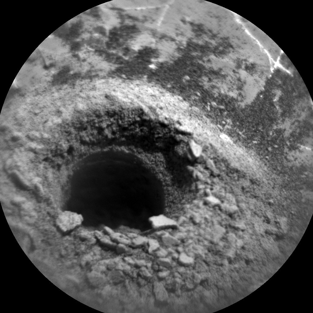
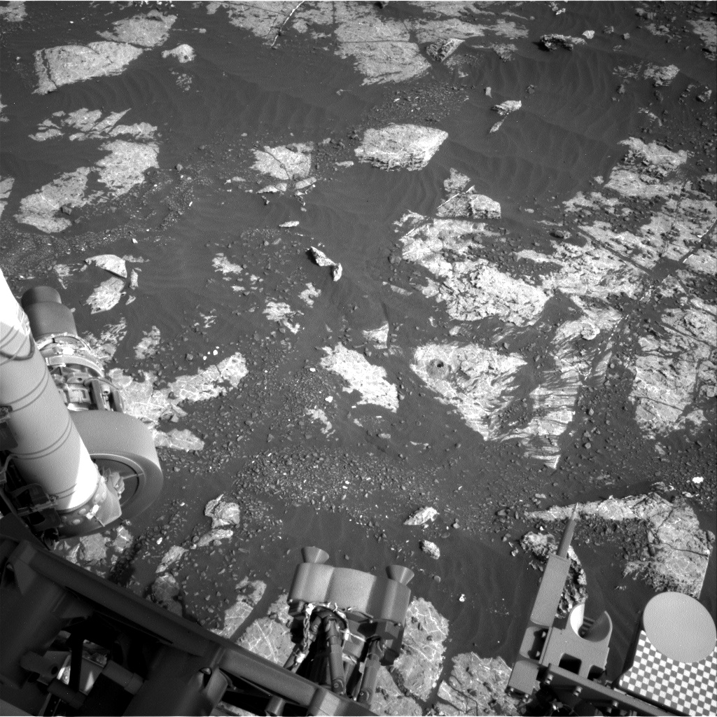
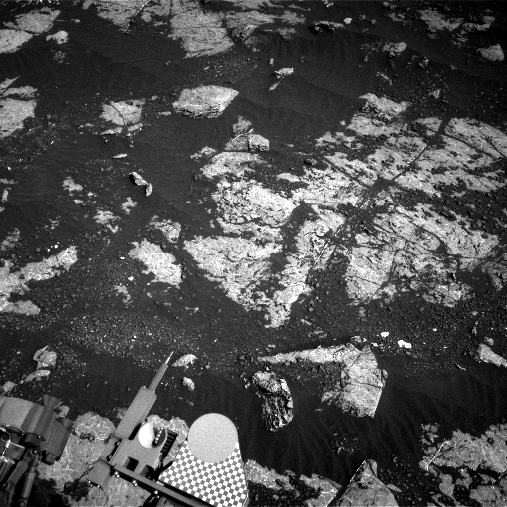
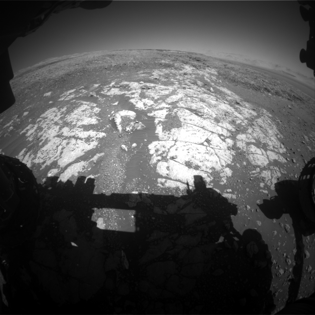
Tosol we received confirmation that Curiosity's drill yestersol was successful, as shown in this Navcam image of the "Highfield" target - our eighteenth drill hole in the martian surface!

Not quite a 'hole in one,' as we tried to sample the same gray Jura rock type about 50 sols ago, but we finally have a sample of our highest value target on Vera Rubin Ridge. Rather than retreat to the club house for a well-earned celebration, however, Curiosity and the team stayed busy in Sol 2225, doing Mastcam and ChemCam imaging of the new drill hole and tailings. This was in preparation for the weekend plan, in which there'll be further imaging and ChemCam LIBS on the drill hole, and samples will be dropped off to CheMin for further analysis.

In addition, there's a packed program of environmental science over the next few sols, now that we're back to full science operations. The global dust storm may have decayed, but we're still interested in seeing whether the post-storm atmosphere differs compared to the same season in previous Mars years when no big storm occurred. Also, we're still in the middle of southern summer, which means lots of 'dust devils' (dust-filled convective vortices) and more dust than usual in the atmosphere. So in addition to our regular meteorological (REMS), radiation (RAD), and sub-surface (DAN) monitoring, we added atmospheric opacity measurements and a 360° dust devil survey into tosol's plan. Over the weekend, alongside the drill sample analysis, there will be a bumper crop of atmospheric activities. These include characterizing the amount and size distribution of dust and water ice aerosols at different times of sol, in and above the crater, by means of a Mastcam 'sky survey' and opacity measurements, a ChemCam 'passive sky' activity, and Navcam cloud movies. We'll also take a dust devil movie as well as two more dust devil surveys.

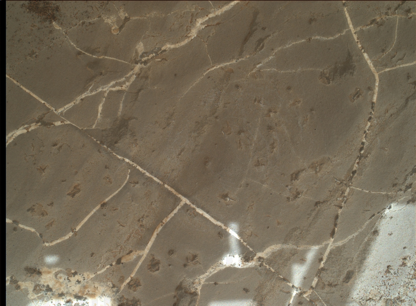
And finally, over the next few sols we'll be watching those drill tailings to see how quickly the martian wind moves them away and in what direction. We'll also be taking 'change detection' images of below the rover with MARDI, and of nearby grains and ripples with Mastcam, again to see what the wind is doing at this time of year in our current location on the slope of Aeolis Mons.

November 8, 2018

Sol 2224: Go for Drilling at Highfield!

Written by Mark Salvatore, Planetary Geologist at University of Michigan
Sol 2224: Go for Drilling at Highfield!

Today was a good day on Mars. The science and engineering teams are making preparations to drill a patch of grey bedrock named "Highfield", which will be our latest attempt to characterize this unique rock unit on Vera Rubin Ridge. Our last attempt to drill into this geologic member of the VRR (nearly 50 sols ago!) was unsuccessful at the drill target "Inverness." This target proved to be extremely resistant and hard, making it difficult for the drill to penetrate deep into the surface and accumulate sample material. So, the science team engaged in quite a bit of discussion about whether the Highfield target is expected to be as hard as or softer than the Inverness target. The team decided that it was worth trying to drill at this location and that the rock has the potential to be softer and more "drillable" than the Inverness target given the data currently in hand. For example, we don't see any fluting of the rock surface as a result of wind erosion, which may indicate that the entire rock erodes relatively quickly. In addition, we see scratches in the rock surface left behind by the rover's Dust Removal Tool (DRT) and other pre-drilling activities, suggesting that the rock is relatively soft.

Today I served as Geology/Mineralogy Science Theme Lead, which meant that I led the discussions between surface scientists and helped to plan the overall approach towards characterizing this region. We were all excited to see the results of yesterday's analyses and surface preparations, and to make the decision to go ahead and try drilling at this location. We'll see if Mars decides to cooperate during tomorrow's planning!

November 7, 2018

Sol 2223: Optimism for "Highfield"

Written by Lauren Edgar, Planetary Geologist at USGS Astrogeology Science Center
Sol 2223: Optimism for "Highfield"

On Sol 2222, Curiosity drove ~10 m towards the "Lake Orcadie" location, in the hopes that we would be able to drill the gray Jura member here. Today's plan is focused on characterizing the target "Highfield," the bright patch of outcrop shown in the middle of the above Navcam image. I was the SOWG Chair today, and it was a pretty straightforward planning day because most of the activities were pre-planned as part of our standard drill site characterization. First APXS will carry out a short integration on the intended drill target, followed by two MAHLI images. Then we'll use the DRT to brush the target, followed by Mastcam imaging and a full suite of MAHLI images. Then we'll do a drill pre-load test, which means that we'll put weight on the drill bit to make sure the surface can support it, and if it makes marks on the surface this might give us an indication of how hard or soft the surface is. Overnight, we'll acquire a longer APXS integration on "Highfield." We were pretty tight on both power and data volume today so it was a bit of a challenge to prioritize everything, but we're optimistic that this will be our chance to sample the gray Jura member. I'll be on duty again tomorrow, so I'm eagerly awaiting our downlink and hoping that we'll be "go" for a full drill hole here!

November 6, 2018

Sol 2222: Déjà vu - Return to Lake Orcadie!

Written by Catherine O'Connell-Cooper, Planetary Geologist at University of New Brunswick
Sol 2222: Déjà vu - Return to Lake Orcadie!

Our attempts to drill grey rock on the "Vera Rubin Ridge" (VRR) continue. We are returning to an area known as "Lake Orcadie," the site of two previous drill attempts (Lake Orcadie and Lake Orcadie 2), which did not penetrate far enough into the bedrock to generate sufficient sample. However, the MSL team feels that the chances of drilling here have improved. Over the past 240 sols, the engineers have further refined the drill technique (here), leading to two successful drilling campaigns (Duluth and Stoer). Additionally, images collected during our previous visit here have helped us to identify three potential drill targets. Criteria such as scratches left in the bedrock by the Dust Removal Tool (DRT) will be used to see if these targets are softer, and therefore more drillable, than our previous choices.

Today's plan focuses on getting the rover to the right location. This involves a short 20 meter drive, to position us so that we are in arm's reach of our target. Science Operations revolve around imaging the drill area, filling in any gaps in our characterization of these potential targets, in order to increase the chance of picking the best one. We also want to make sure that any drill fines generated during our previous attempts here have blown away, so that instruments such as MAHLI can operate safely.

Other activities included standard environmental monitoring activities, e.g., dust devil movies, and a CCAM observation on a piece of rock ("Flotta") which might represent red Jura bedrock (rather than the grey bedrock we are hoping to drill).

If our bump goes as planned, we will complete our final confirmation analyses on the bedrock this week, and begin drilling before the weekend.

November 2, 2018

Sols 2219-2221: Curiosity goes bump!

Written by Kristen Bennett, Planetary Geologist at USGS Astrogeology Science Center
Sols 2219-2221: Curiosity goes bump!

Yesterday Curiosity drove for the first time since sol 2166! Our intrepid explorer is truly back at it after a few weeks off due to the anomaly. The short drive (also called a bump) placed us in a workspace a few meters away from our previous location where we had attempted to drill (see image above that shows a MAHLI observation of the shallow drill hole).

In this weekend's three-sol plan there will be several diagnostic activities that will help us to understand the anomaly. In addition to the diagnostics, the weekend plan includes ChemCam and Mastcam observations of "Dryden" and "Kirkness," which are bedrock targets, and of "Housay," which is a vein within the bedrock. Also included is a Mastcam observation of "Eynhallow" to document laminations within the bedrock, a MARDI image, and a Navcam dust devil survey.

There are ChemCam RMI Zenith Sky Flats scheduled on the first sol. In this activity ChemCam will take images looking up at the sky. This activity needs to happen near sunset because ChemCam should not look directly at the sun. These sky flats help us determine whether there is any dust contamination on ChemCam's optical window, which is important right now because Mars just experienced a global dust event.

On the second sol, APXS and MAHLI will be used to investigate two targets: "Calgary" and "Findon." Calgary is typical gray bedrock, and this target will be brushed with the DRT prior to the MAHLI and APXS measurements.

On the third sol Curiosity will drive towards Lake Orcadie, and next week we plan to start our drill campaign in the gray colored rocks at that location!

November 1, 2018

Sol 2217: A BOO-tiful Halloween on Mars - Curiosity's Return to Contact Science

Written by Lucy Thompson, Planetary Geologist at University of New Brunswick
Sol 2217: A BOO-tiful Halloween on Mars - Curiosity's Return to Contact Science

Mastcam left image showing the Inverness and Grange targets in the workspace.

Today was an exciting day for me as a member of the APXS team and filling the role of payload uplink lead, as Sol 2217 marked a return to contact science activities after our anomaly on Sol 2172. When the anomaly occurred, the APXS was poised to measure the composition of the freshly exposed "Inverness" bedrock surface (after an unsuccessful drill attempt on Sol 2170) to compare with the previously brushed surface and other fresh rock surfaces examined by APXS on the Vera Rubin Ridge. The plan today is to recover this measurement, with accompanying MAHLI imaging, as well as to get chemical and textural data (with APXS and MAHLI) on another interesting target in the workspace, "Grange." "Grange" appears to be an area of bright calcium sulfate (commonly observed as veins cross-cutting bedrock encountered throughout the mission), but with small, dark inclusions that might have an interesting composition.

We also planned ChemCam on a bedrock target "Clune" with accompanying Mastcam imaging, as well as Mastcam imaging of an interesting area of rougher textured rock "Ayr" and multispectral Mastcam observations of the "Inverness" area. The plan was rounded out with some environmental monitoring activities including DAN passive and REMS.

I am looking forward to getting the data down from these observations and comparing the chemistry and textures of these rocks with other rock targets encountered on the Vera Rubin Ridge. The chemistry and textures can provide clues to the conditions the sediments were deposited in as well as subsequent events such as diagenesis (as the sediment is buried, compacted and cemented and turned into a rock), and later alteration.

Looking ahead, Curiosity is hoping to soon drive away from this site towards an area, "Lake Orcadie," where we will attempt another drill into one of these interesting bright grey areas identified from orbit on the Vera Rubin Ridge.