January 28, 2019

Sols 2301-2303: Looking Forward to the Clay-Bearing Unit

Written by Ryan Anderson, Planetary Geologist at USGS Astrogeology Science Center
Sols 2301-2303: Looking Forward to the Clay-Bearing Unit

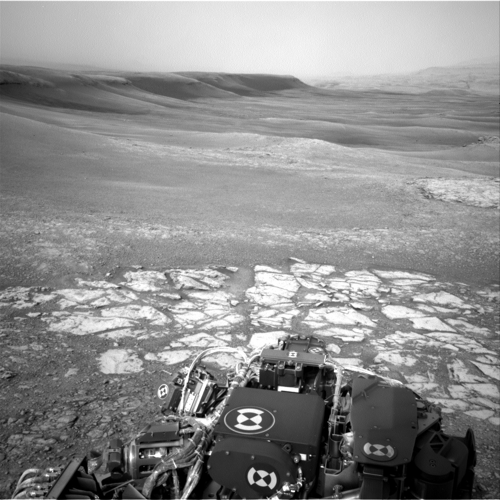
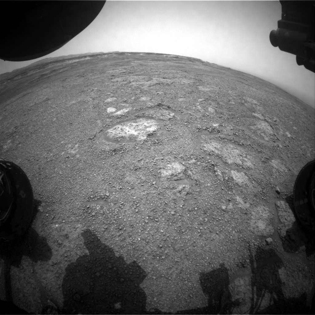
This weekend's plan started off on Sol 2301 with some Mastcam atmospheric observations, followed by ChemCam analysis of "Loch Ness" and "Loch Skeen," examples of brown and gray bedrock. ChemCam also had a long-distance image mosaic of an interesting outcrop in the clay-bearing unit. Once the remote sensing was done, it was time for some contact science. MAHLI collected some images of Loch Ness before and after it was brushed, as well as the target "Puddledub." APXS then took a turn, with a quick analysis of Puddledub and an overnight analysis of Loch Ness.

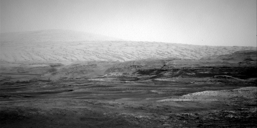
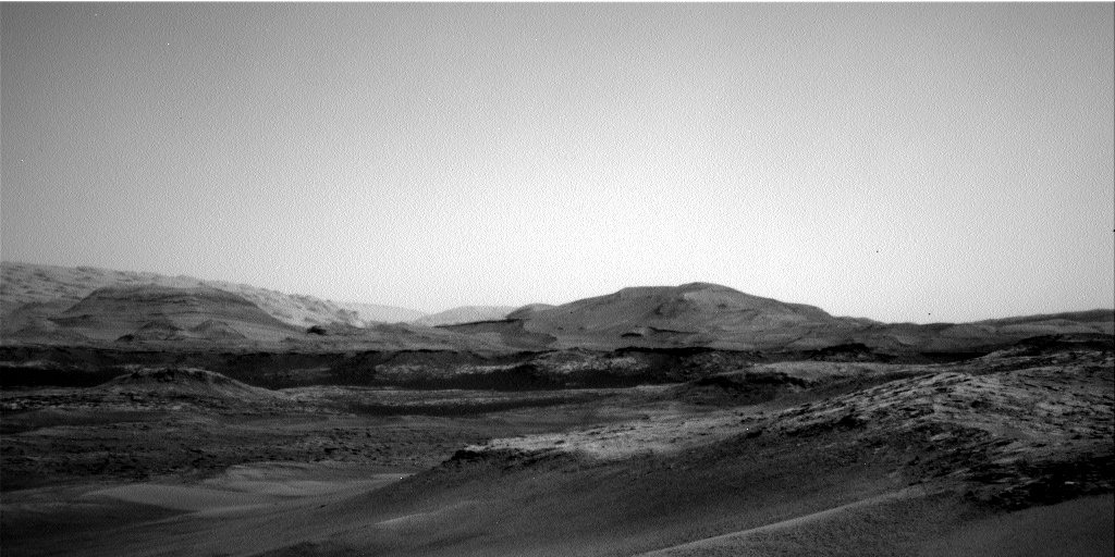
On Sol 2302, we started off with a Navcam atmospheric observation, followed by Mastcam multispectral observations of Loch Ness and Loch Skeen. Mastcam also had a large stereo mosaic surveying the clay-bearing unit that we will soon be exploring. We then drove for about 32 meters and collected some post-drive imaging including our routine Mastcam "clast survey" to document changes in the rocks and soils along our traverse, as well as some additional Navcam images to help with imaging the pediment that is looming large just beyond the clay-bearing unit. This was followed by some Mastcam atmospheric observations and a MARDI image of the ground beneath the rover.

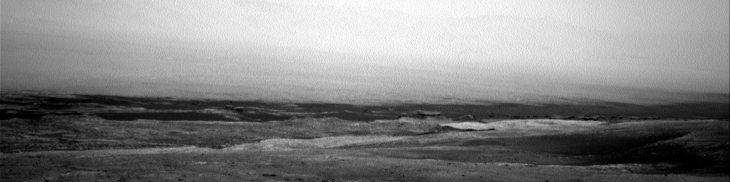
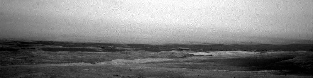
Sol 2303 was dedicated to atmospheric observations, with the usual Mastcam "tau" images plus several Navcam movies. Some of these were pointed at the sky to watch for clouds, while others were pointed out across the crater floor to watch for dust devils.

January 24, 2019

Sol 2300: Beam me up Scotty!

Written by Lucy Thompson, Planetary Geologist at University of New Brunswick
Sol 2300: Beam me up Scotty!

Navcam Left image looking along the back edge of the Vera Rubin Ridge (top left to top centre) down into the clay-bearing unit.

Curiosity is on the brink of descending down off the Vera Rubin Ridge (VRR) onto the clay-bearing unit. We are hoping to 'beam up' lots of interesting new data to the Mars orbiters, to be relayed to Earth after executing our plan on Mars tosol. We planned a typical 'Touch and Go' sol today, which includes using the arm to place our contact science instruments (APXS and MAHLI) on a rock target to document chemistry and texture, followed by remote science by ChemCam and Mastcam to also look at chemistry and the larger scale view out the front window, before a drive. We are documenting how the chemistry and appearance of the rock is changing as we transition from the resistant VRR to the less resistant, orbitally distinct clay-bearing unit, and taking larger-scale images and mosaics to assist in future planning of our investigation of the clay-bearing unit.

We chose a reddish-purple, laminated bedrock target for APXS and MAHLI and selected the name "Linlithgow," which is apparently the birthplace of Mary Queen of Scots and the future birthplace (in 2222) of Montgomery "Scotty" Scott, chief engineer of Star Trek's Enterprise (hence the title)! The great grandfather of one of our science team members also compiled an anthology of poetry from the area in 1896, so a popular choice of name! Mastcam images will be taken of this target and an adjacent, rougher textured and different coloured bedrock target, "Stoneywood" (also a ChemCam target), to look for spectral variations between the two areas. The more typical bedrock target, "Stornoway" will also be analyzed for composition by ChemCam. A large Mastcam mosaic of 21x2 images was also planned of an area named "Boyndie Bay" to document some interesting features that we are thinking of visiting during our investigation of the clay-bearing unit.

The planned drive should take us to the very edge of the VRR, and will likely be our last stop before we drive down onto the clay-bearing unit. We are acquiring images to facilitate a full weekend of science activities at this important location, as well as a post-drive DAN active measurement to investigate the distribution of subsurface hydrogen.

Additional Mastcam images and REMS meteorological observations were planned to monitor dust in the Martian atmosphere.

January 23, 2019

Sol 2299: Melrose Place

Written by Scott Guzewich, Atmospheric Scientist at NASA's Goddard Space Flight Center
Sol 2299: Melrose Place

Curiosity is continuing the first phase of its journey to the "clay-bearing unit," the low elevation portion in the middle distance of this Navcam image with a series of "touch-and-go" driving sols. During these sols, the rover does contact science with MAHLI and APXS in the morning, some additional remote sensing as time permits, and then drives away to a new location during the afternoon. We want to closely examine the bedrock as we drive to help understand how the Vera Rubin Ridge and the clay unit are related.

Today, "Melrose" was the target for contact science. Additional Mastcam and ChemCam observations were taken of other nearby geological targets. Curiosity is continuing to monitor a strong late-season dust storm that's increased the amount of dust locally for the last 1-2 weeks with Navcam and Mastcam observations of the atmosphere as well as an increased cadence of REMS meteorological observations.

January 22, 2019

Sol 2298: Commencement of the Clay-Bearing Unit Campaign

Written by Roger Wiens, Geochemist at Los Alamos National Laboratory
Sol 2298: Commencement of the Clay-Bearing Unit Campaign

Curiosity has moved for the first time since December 13, 2018. More importantly, Curiosity is moving to a new geological unit that we have so far called the "Clay-Bearing Unit" (CBU). The MSL rover team, following previous rover teams, has organized itself into different campaigns to explore different geological units. Organizers are nominated to lead these campaigns, and their job is to help coordinate among the competing interests of the different instrument teams, helping to make synergistic, collaborative discoveries. The organizers of the CBU campaign have been patiently waiting for their turn to lead the campaign. After all, their first meeting was well over a year ago, on October 3, 2017.

Curiosity has not actually arrived yet. The rover team is searching for the geological contact between bedrock of Vera Rubin Ridge and that of the CBU. The precise boundary is not clear from orbit, and it could also be a relatively gradual change as seen from rover images. To have the best chance at observing the transition, Curiosity is doing relatively short drives, interspersed with frequent observations by both remote and contact instruments, as the terrain allows.

The rover drove about 38 meters over the holiday weekend, and ChemCam made a post-drive observation using AEGIS software. Before tosol's drive ChemCam will shoot a 5x1 raster on "Oldmeldrum," 10x1 rasters on "Dyce," "Banchory," and "Elrick." ChemCam will also take a 3-image mosaic of a feature of interest in the sulfate unit. Mastcam will image all of the local ChemCam targets including yestersol's AEGIS target, and will image one additional target, "Dalmellington," which is a rock with a protrusion. Navcam will take a movie looking for dust devils, and Mastcam will take an image to check the tau (atmospheric opacity) and a crater rim extinction image. After the drive the rover will image the local terrain with Navcam and Mastcam, including a 360 degree observation with Navcam and a clast survey with Mastcam. MARDI will take a post-drive image of the ground below the rover close to sunset. DAN, RAD, and REMS will also collect data, as usual.

January 18, 2019

Sols 2295-2297: Just can't wait to get on the road again

Written by Melissa Rice, Planetary Geologist at Western Washington University
Sols 2295-2297: Just can't wait to get on the road again

Sometimes the best laid plans of rovers go astray. After wrapping up at the Rock Hall drill site yesterday, the plan was for Curiosity to start driving towards the clay-bearing unit (our first drive in about a month), starting with a series of small bumps so that MAHLI could take images of the full outer circumference of the wheels (as described in the blog for Sols 2293-2294). However, an arm fault prevented yesterday's drive from executing, and today Curiosity remains parked in front of Rock Hall.

The good news is that we get one more day to explore this spot. Before we reattempt the MAHLI wheel imaging and the drive, Curiosity will use the DRT to brush dust off of the target Bothwell, image it with MAHLI, and collect chemical data overnight with APXS. ChemCam will explore a few more targets here as well, including LIBS observations of the bedrock targets "St Ninians Tombolo," "Stac Pollaidh" and "St Cyrus 3," and a long-distance RMI mosaic of a butte of layered sulfate-bearing rocks towards Mount Sharp. After this bonus science, Curiosity will make the first of several eastward drives to exit the Vera Rubin Ridge and enter the clay-bearing unit. When we return from the Martin Luther King Jr. Day holiday next week, hopefully we'll be greeted with images of a brand-new workspace to explore!

January 18, 2019

Sols 2293-2294: On the road again

Written by Michelle Minitti, Planetary Geologist at Framework
Sols 2293-2294: On the road again

It has been a productive stay at the "Rock Hall" drill site. The number and diversity of analyses performed on the drill target and drilled sample itself - mineralogy from CheMin, organics and volatiles from SAM, chemistry and spectral characteristics of the bedrock, drill tailings and excess drilled sample from APXS, ChemCam, and Mastcam - speak to the importance of samples we so painstakingly extract from Mars. After acquiring an image of the drill hole using MAHLI to pinpoint APXS's placement over the drill tailings the evening before, we depart for our next adventure - the clay-bearing unit. This unit, which lies between us and the next set of mesas further up Mount Sharp, exhibits a strong spectral signature of clay minerals from orbit. As clays are associated with the action of water and, typically, that of neutral pH waters, we are keen to learn about the nature and origins of the clays and the rocks that host them.

Our first move is a series of bumps that will scoot us forward 2 m as we image the wheels that will carry us to the clay-bearing unit and beyond. The process, called full MAHLI wheel imaging, involves poising MAHLI obliquely above the wheels to image them, stowing the arm, bumping forward a few tens of centimeters to bring the next segment of wheel into view, unstowing the arm, and imaging the wheels once again. It takes 4 small bumps to fully image the outer circumference of the wheels. The first set of wheel images was acquired by MAHLI on Sol 2291, one of which is featured above. Even with the bumps and tears visible in this image, the wheels are still capable of carrying us for many more kilometers across the clay-bearing unit and up Mount Sharp! As we bump forward to take the wheel images, we will also acquire a MARDI image at each stop, resulting in a tightly overlapping set of MARDI images that can be combined to create a digital elevation model of the terrain under the rover. The final stop will place the Rock Hall drill hole in the MARDI field of view, giving MARDI our last look at Rock Hall.

After we drive, we will image our first new workspace in about a month, acquire a ChemCam raster using the automated AEGIS targeting system, and acquire a host of Navcam and Mastcam images and movies to monitor changes in the atmosphere caused by the regional dust storm. Perhaps Curiosity will have another up-close-and-personal encounter with a dust devil!

January 17, 2019

Sol 2292: Dust to Dust

Written by Brittney Cooper & Claire Newman
Sol 2292: Dust to Dust

Today was our last day at "Rock Hall," so it was our final chance to get every last bit of science at this location. We had a 2.5 hour science block filled with Mastcam change detection imaging of the Rock Hall drill fines and alternating ChemCam RMI and LIBS observations of the Rock Hall dump pile, drill tailings, and target "St.Cyrus 2." The ChemCam activities were followed by Mastcam documentation images of each of the aforementioned targets, and we also included a B-side computer diagnostic and an overnight APXS of the Rock Hall drill tailings.

Gale Crater has become a lot dustier in recent sols due to a regional dust storm in the southern hemisphere that was spotted by the Mars Climate Sounder team, so we added several extra environmental observations to see how this is affecting the atmosphere. These included extra measurements of the amount of dust above us (with the observation known as the "Mastcam tau") and of visibility across the crater (with the "Navcam Line of Sight" and "Mastcam Crater Rim Extinction" observations).

We also added more REMS 1-hr measurements to better capture the diurnal cycles of pressure and temperature. When the regional or global dust loading increases, it changes how the atmosphere expands and contracts in response to solar insolation, which affects how air moves around and alters the large-scale patterns of surface pressure (since pressure is caused by the mass of air in a column over the surface). We monitor this by seeing how the shape of the daily pressure cycle changes from sol to sol. More atmospheric dust also means more of the incoming solar radiation is absorbed before it reaches the rover, so daytime near-surface and ground temperatures decrease compared to normal. At night, however, the warmer overlying atmosphere emits more thermal radiation, keeping the temperature of the surface and near-surface warmer than usual. More dust heating also means that near-surface and surface temperatures are more strongly coupled, resulting in a reduced surface-to-air temperature contrast, all of which REMS measurements are starting to show.

Another effect of increased dustiness is therefore that we expect to observe fewer convective vortices and dust devils (dusty vortices), because a smaller surface-to-air temperature difference means less heat is pumped into the atmosphere to drive convection. So tosol we also included three types of Navcam dust devil searches, to see if the dust activity produces a decrease in the number or size of dust devils.

Navcam: Left A (NAV_LEFT_A) onboard NASA's Mars rover Curiosity on Sol 2256

Navcam: Left A (NAV_LEFT_A) onboard NASA's Mars rover Curiosity on Sol 2256
We'd normally expect to see a lot of dust devils in the current season (local summer). In fact, one passed right over the rover just as we were taking a movie a few sols before the dust began to increase! The second of the two frames above shows a slight reduction in visibility as this happened; at the same time, the dust devil's low-pressure core produced the largest vortex pressure drop ever measured on Mars (over 7 Pa, which is about 1% of the total surface pressure). Although we can't 'see' the dust devil in the images, we can tell the rover was inside one because of the decrease in visibility combined with the dramatic decrease in pressure.

January 14, 2019

Sol 2291: Selfie time at Rock Hall: say cheese!

Written by Rachel Kronyak, Planetary Geologist at NASA's Jet Propulsion Laboratory
Sol 2291: Selfie time at Rock Hall: say cheese!

Today we planned a single sol of activities, Sol 2291. As we begin to wrap up our activities at the Rock Hall drill site, Sol 2291 is chock full of science observations. We'll begin the sol with an hour-long science block. Our environmental group (ENV) planned several activities to measure increasing dust levels in the atmosphere; these observations will occur at the start of the science block. Following ENV's activities, the geology group (GEO) planned a ChemCam observation on a soil target near the rover named "Loch Monar" as well as a long-distance Remote Micro-Imager (RMI) image of the sulfate unit on Mount Sharp. Following ChemCam, Mastcam will take images of targets "Loch Monar" and "Stroma." The "Stroma" target is an interesting small rock just in front of the rover.

After the science block, we will take a series of images with our MAHLI camera. First, we'll take a 57-frame self portrait (or selfie). Up next for MAHLI is part one of a wheel imaging campaign, which we do periodically to monitor the health of the wheels. We'll take several images today, and more images after we drive later on in the week. Overnight, APXS will perform an analysis on the Rock Hall dump pile. This will be our second observation on the dump pile; our weekend analysis didn't get the entire pile within APXS's field of view.

Tuesday is a no-planning "soliday," which happens approximately every 38 days. These solidays allow our Earth schedule to catch back up with the slightly longer Mars day. We will resume planning Sol 2292 on Wednesday.

January 11, 2019

Sol 2288-2290: Drilling activity completed, almost.

Written by Susanne Schwenzer, Planetary Geologist at The Open University
Sol 2288-2290: Drilling activity completed, almost.

Image taken by the Front Hazcam: Left A (FHAZ_LEFT_A) onboard NASA's Mars rover Curiosity on Sol 2286. The drill hole is the dark feature on the largest light toned area on the large block slightly to the left of center of the image.

We will soon be leaving the Rock Hall area, thus this one last look at the drill site from a hazard camera perspective. Seeing those holes always is special, even for #19!


In today's planning, we will dump the remaining rock powder from the drill and investigate it with all instruments, starting with APXS, which will perform a two-step raster. Sol 2288 contains a range of ENV investigations, dedicating the morning science block on sol 2288 to a passive sky observation and a Mastcam tau to see how the dust loading in the atmosphere is changing. The science block of sol 2289 is dedicated to spectral analysis of the dump pile with ChemCam passive and Mastcam multispectral investigations.


ChemCam is holding off on its active LIBS observations of the dump pile until we know that APXS and the spectral analysis completed successfully, thus there are two bedrock observations in the sol 2290 plan, the targets are Dufftown and Lairg. Both will be investigated with 10-point rasters to further capture the bedrock variability we have been seeing. Monday's plan will be the last one at Rock Hall before we start our descent of the ridge and into the clay unit. I am excited to explore the new terrain, and so is the entire team!

January 10, 2019

Sols 2286-2287: Starting the wrap-up at Rock Hall

Written by Catherine O'Connell-Cooper, Planetary Geologist at University of New Brunswick
Sols 2286-2287: Starting the wrap-up at Rock Hall

Our onboard instruments SAM (Sample Analysis at Mars) and CheMin (Chemistry and Mineralogy) have come to the end of their investigation of the Rock Hall target, likely to be our last drill location on the Vera Rubin Ridge, so this 2-sol plan is the beginning of the drill operation wrap up. On the first sol (2286) SAM will "doggie bag" some sample, saving it for further experimentation in future weeks. The second sol of the plan (2287) will centre on preparations to "dump" the remaining sample from the drill onto the ground in the weekend plan, so that it can be analyzed by APXS, MAHLI, Mastcam and ChemCam. For example, Mastcam will image the Rock Hall drill hole, to monitor the degree of movement of the drill fines in the 3 weeks since our drilling.

The Geology (GEO) theme group planned ChemCam LIBS observations on four targets within the workspace. "Deveron" is a typical bedrock target, to help further characterize the bedrock in this area. "Burra" has an interesting pitted texture, whilst "Braeriach" has a shiny appearance. "Gometra" is a potential iron meteorite, which has been previously targeted, but warranted further investigation. Mastcam will take colour images of the LIBS targets, in addition to remote sensing of the "Greenheugh" pediment, further up the slopes of Mount Sharp. The Environment (ENV) theme group is continuing to document dust levels in the atmosphere, via a Mastcam sky column activity, and a full tau/extinction pair of images. Additionally, DAN passives and standard REMS activities are throughout the plan.