March 4, 2019

Sol 2338: Finishing up at Midland Valley

Written by Rachel Kronyak, Planetary Geologist at NASA's Jet Propulsion Laboratory
Sol 2338: Finishing up at Midland Valley

Today we planned Sol 2338 chock full of science activities to finish up our observations at the "Midland Valley" outcrop. We'll primarily use our Mastcam and ChemCam instruments to take a closer look at some interesting rock targets in our workspace.

We'll kick off our block of science activities on Sol 2338 with a Mastcam mosaic looking ahead of the rover, where the team identified an interesting area of fractured bedrock, pictured in the Navcam image above; we named this target area "Longhope." After that, we'll use the ChemCam laser to analyze rock targets "Miller" and "Cuttyhill." We'll then take multispectral Mastcam images of targets Cuttyhill and another interesting rock named "Leslie." After our science observations, we'll hit the dusty trail and drive towards our next bedrock-rich destination, an area called "Milltimber." To finish up the plan, we'll take some post-drive images to survey our new parking spot and prepare for more science observations! We'll also perform an atmosphere monitoring activity with Navcam to look for dust devils.

February 28, 2019

Sol 2333: Back in action at Midland Valley

Written by Melissa Rice, Planetary Geologist at Western Washington University
Sol 2333: Back in action at Midland Valley

Image of the "Midland Valley" outcrop taken by the Left Navigation camera onboard NASA's Mars rover Curiosity on Sol 2320.

Curiosity returned to science planning today after a two week hiatus because of a technical issue. Our most recent science plan, described in the blog for Sols 2320-2323, included a drive towards a blocky outcrop called "Midland Valley." The drive was a success, bringing us right on top of the beautiful chunk of rock shown above - but before we could reach out and touch it, Curiosity went into safe mode. While the engineers worked to return Curiosity to nominal operations, the science team stood down from planning, eagerly awaiting our chance to get a closer look at Midland Valley.

Today's plan includes that closer look. With Mastcam, ChemCam, MAHLI and APXS, we'll investigate two spots on the outcrop: "Alloa" and "Auchterarder." Mastcam will also survey our surroundings with mosaics of wind-blown sand features ("Mormond Hill," "Motherwell" and "Mount Keen"), a look back at our previous workspace (towards the previously-explored targets "Curlew" and "Gannet"), a look ahead towards a potential future drive destination (at an area with blocky outcrop called "Milltimber"), and a look up to the sky at the dust in the atmosphere. In addition, ChemCam will use LIBS (the laser) to investigate another rock target called "Crathes."

The engineering team is working hard to understand the issue that occurred on sol 2320, and upcoming plans will be dedicated to diagnostic activities. We will update you as we learn more, and in the meantime, the new observations from Midland Valley will keep us scientists busy!

February 14, 2019

Sols 2320-2323: Onwards to Midland Valley

Written by Catherine O'Connell-Cooper, Planetary Geologist at University of New Brunswick
Sols 2320-2323: Onwards to Midland Valley

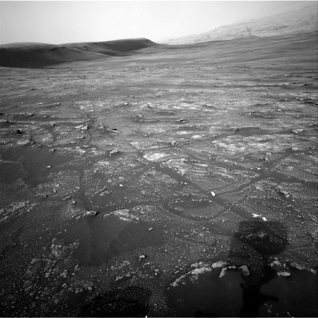
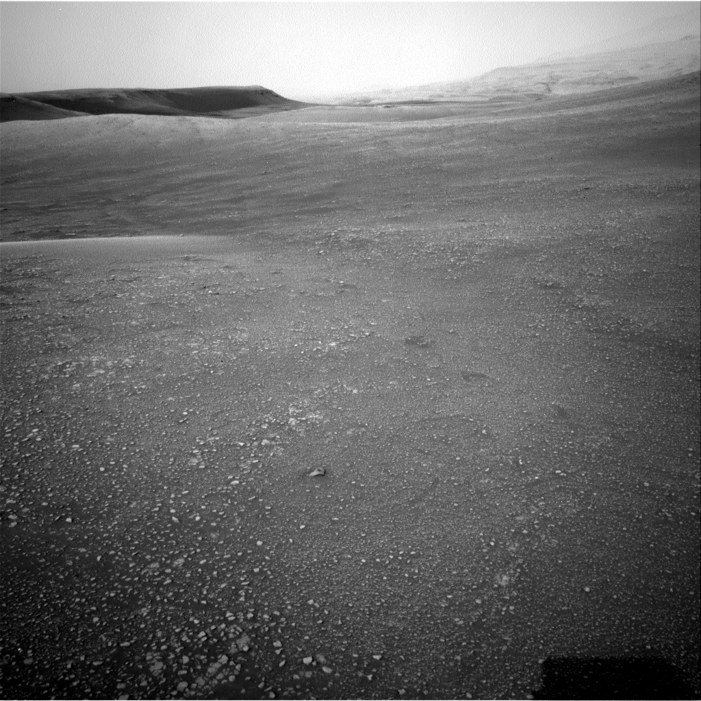
Front Hazcam image, showing the current workspace. This is a block of more coherent bedrock, surrounded by rubbly terrain, with lots of small rocks, pebbles and sand.

Today was a very busy planning day for the Curiosity operations team. We planned a 3-sol plan, with contact science, imaging, environmental monitoring and a drive.

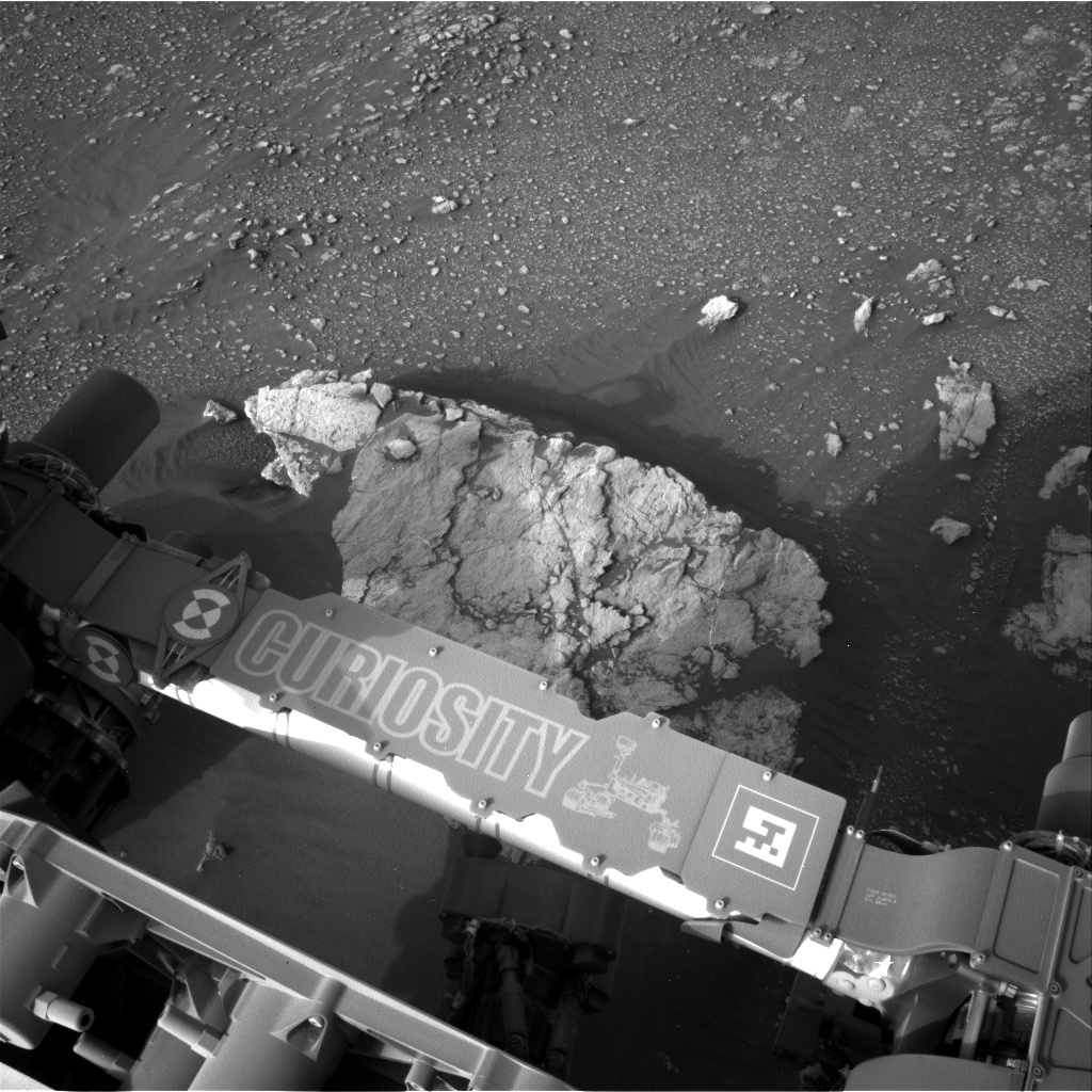
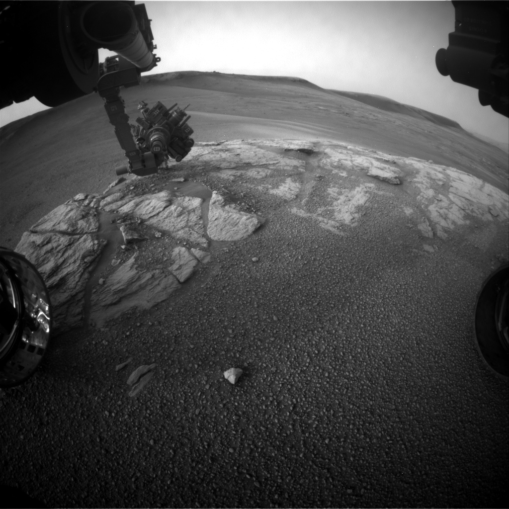
Our weekend plan brought us to a block of coherent rock, a treat after spending many workspaces in more broken up and rubbly areas. The Geology (GEO) theme group uplinked lots of contact science here on Monday, so we are ready to leave and drive on to the next coherent block we have identified in the distance, a target known as "Midland Valley." Before leaving however, we planned contact science on "Ladder Hills," a beautiful example of laminated bedrock. APXS will be used to determine the chemistry, to compare it to our other targets in this workspace "Gannet" and "Curlew." MAHLI will take images of the laminations within Ladder Hills from two different angles - straight downwards onto the rock surface (the spot where APXS will also analyze), and from an oblique angle. ChemCam will acquire active LIBS (laser) analysis of Ladder Hills, in addition to analysis of "Fyvie," a large pebble for comparison with bedrock targets.

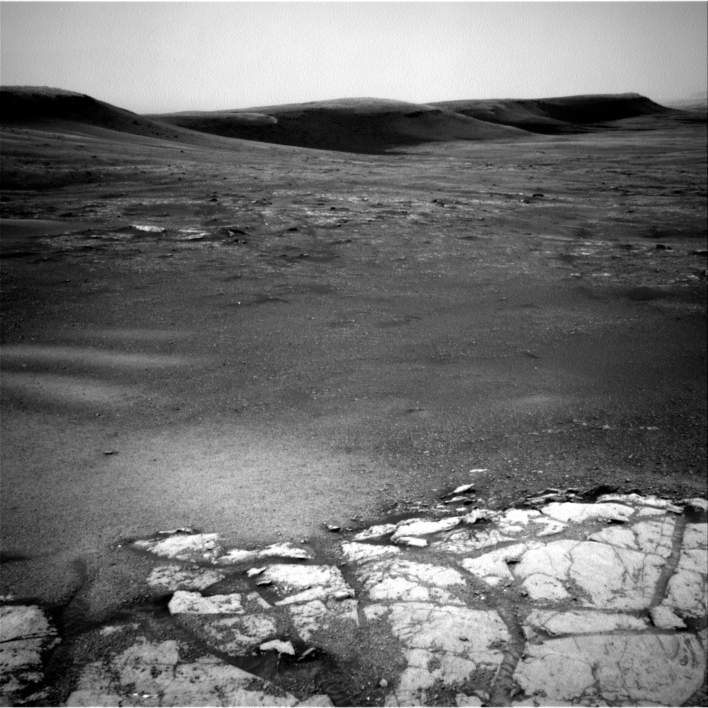
The plan features lots of Mastcam imagery. Both Fyvie and the post-drive AEGIS target will be imaged, in support of ChemCam science activities. Two mosaics will focus on the laminations in the workspace, in the targets Ladder Hills, "Ladyburn" and "Loch Gelly." Multispectral documentation will be taken of the Curlew target, which was brushed in Monday's plan. There is a mosaic of two linear ridges in the distance ("Gilles Hill").

Mid-way to our next stop at Midland Valley, we will stop at a small ripple field. Using Mastcam, we will image the undisturbed sand, before scuffing using the right wheel, back away a little, and then take another Mastcam image of the disturbed sand. These images will be used to further characterize the physical properties of the sand in this area. Then our drive resumes, hopefully ending on bedrock for our upcoming weekend plan. Following the drive, APXS will do overnight measurements of argon in the atmosphere, as part of a long range experiment looking at changes in argon abundances and seasonal variations.

In parallel to the very full GEO plan, the Environmental (ENV) theme group also has a very full plan. The main ENV activity is a ChemCam Passive Sky observation, which lets us measure the column abundance of water vapor, oxygen, water ice and dust in the atmosphere, and also gives us some idea of dust and water ice particle sizes. This is particularly interesting as we just had some regional dust storm activity on Mars, so there's still quite a lot of dust in the atmosphere above the rover. For this reason, we're also very interested in the two Mastcam atmospheric opacity measurements in this plan, which will tell us how much dust is still up there; recently, opacities have been trending down. ENV planned some Navcam movies, as part of an ongoing campaign to examine martian clouds, their properties and abundances. The "zenith" movie looks directly upwards to look at clouds and their direction, whilst the "suprahorizon" movie is targeted in a more horizontal direction, looking at clouds and variations in optical depth in the atmosphere above the north rim of the crater. ENV also planned Navcam and Mastcam "dust devil" movies and surveys, which measure the number, location, and characteristics of dust-filled convective vortices, which in turn tells us about surface heating, convection, and winds near the surface. These observations are targeted lower than the suprahorizon movies, to search for dust devils across the crater floor on the slopes of Mount Sharp. Excitingly, this plan sees the very first use of Mastcam to take a dust devil movie, which will give colour images and better resolution (although over a smaller region) than Navcam. Finally, there were also standard RAD, REMS and DAN activities.

February 11, 2019

Sol 2315-2317: Exploring the New Terrain - One Measurement at a Time

Written by Susanne Schwenzer, Planetary Geologist at The Open University
Sol 2315-2317: Exploring the New Terrain - One Measurement at a Time

Image taken by the Left Navigation camera onboard NASA's Mars rover Curiosity on Sol 2313 (2019-02-07 15:05:46 UTC) during the observation of the target "Alba."

Curiosity is driving across the clay-bearing unit, which is still a very new terrain with many details yet to be understood. The region is covered in little pebbles - and has lots of small sand patches, too, both of which we continue to investigate. The Navigation camera image above shows the APXS being deployed on the sand patch Alba that was investigated on sol 2313. After that, the drive took us a little further north, to be exact, Curiosity drove 39 metres from the last location.

The parking location presented us with the same pebbly-strewn surface as before, with the occasional small sand feature. With this terrain being new, and some small-scale sedimentary features spotted by the eagle-eyed sedimentologists on the team, we decided to use ChemCam on three pebbly targets, "Dauntless," "Otter," and Thistle." The team also found - for the first time in this new unit - a pebble large enough to get a full APXS raster on one continuous piece of rock. Yes, this is how small the pebbles are! We used the opportunity, named the target "Emerald," and investigated it using a 3-spot APXS raster, accompanied by MAHLI observations on this target. To put all the small pieces into context, we planned a large Mastcam multispectral raster investigation covering the workspace in front of the rover, and including the targets "Dauntless," "Faoilean" (a sand patch), and the APXS target "Emerald." It also covers some of the sedimentary details that were spotted in the post drive imaging. Two further Mastcam observations target aeolian features (target "River Brora") and a small ridge ahead of the rover, named "Osprey."

ENV included atmospheric opacity measurements with both Mastcam and Navcam, as well as cloud observation movies and a dust-devil survey in our weekly morning suite. Now that the regional dust event has declined, we are seeing an uptick in dust devils!

The drive is targeted towards a small outcrop - the largest piece of continuous rock so far seen in the new terrain. Go, Curiosity, geo-minded Earthlings will love to get close and personal to an outcrop soon again!

February 11, 2019

Sols 2318-2319: Touring Glen Torridon

Written by Lucy Thompson, Planetary Geologist at University of New Brunswick
Sols 2318-2319: Touring Glen Torridon

Left Navigation Camera image of the Glen Torridon area. The bright exposure of rock in the foreground is the top of the area being interrogated by the contact science instruments in the plan tosol. This gives way to the rubbly and sandy terrain in the background, with a few areas of bedrock exposure, flanked by the southern edge of the Vera Rubin Ridge behind.

Similar to its namesake in Scotland, the Glen Torridon area on Mars affords us stunning vistas, but in our case, of the relatively low-lying clay bearing (from orbit) unit flanked to the north by the higher ground of the Vera Rubin Ridge and to the south, by Mount Sharp. We have been capturing the views with our cameras, Mastcam, Navcam and Front Hazcam and stopping for a taste of what this area has to offer by analyzing the local terrain with our suite of contact science instruments, as well as with ChemCam and Mastcam. The plan tosol is no exception.

The drive we took over the weekend, went off without a hitch and placed us on one of the few examples of more coherent, in-place bedrock exposures in the area. As such, we decided to put the brakes on and take some time to investigate in more detail. We will deploy the arm to first brush a typical area of this bedrock "Curlew," in an attempt to remove as much of the Mars surface dust as possible, before taking some close-up images of the target with MAHLI and then analyzing it for chemistry with APXS. The arm will also place us to take close up MAHLI images and obtain chemistry with APXS of another slightly different looking area (colour and texture) of exposed bedrock ("Gannet"). To complement these observations, we also planned ChemCam LIBS on the "Gannet" target, and Mastcam multispectral observations to cover both targets to look for spectral variations across the outcrop. ChemCam will also investigate the composition of 2 other bedrock targets ("Beryl" and "Ladyburn"), and a pebble target ("Southness") with LIBS and we will increase our colour image coverage of this exposure with Mastcam. DAN active and passive measurements were also included to investigate the distribution of subsurface hydrogen in the bedrock and regolith.

We also planned a large Mastcam mosaic to capture the view out the front window. It will include the cliffs of the Vera Rubin Ridge as well as the drive direction, which is a mixture of rubbly rock and sand and low-lying bedrock exposures, one of which ("Midland Valley") we hope to drive to next.

The data we collect will help us to compare the Glen Torridon area with other regions we have encountered on the mission; specifically the rocks we analyzed on the Vera Rubin Ridge, as well as the other Murray formation sedimentary rocks we encountered prior to the Vera Rubin Ridge. It will also allow us to place this area in context as we continue to climb Mount Sharp.

Curiosity is also monitoring the environment as she tours Glen Torridon. We included standard background REMS activities that monitor the daily martian weather, two Navcam dust devil movies and a Navcam dust devil survey. We also continue to monitor the radiation environment with RAD.

A fun, busy day of planning on Mars with lots of great observations. Not only did I monitor planning activities in order to write this blog, but I also got to choose some of the targets we ended up analyzing, and as the APXS payload uplink and downlink lead, I am in the process of preparing the commands that will be sent to the rover to execute our planned measurements on Mars. I also got to check that our instrument was healthy and ready for planning today after the weekend activities.

February 6, 2019

Sol 2313-2314: Cruising the Clay-bearing Unit

Written by Scott Guzewich, Atmospheric Scientist at NASA's Goddard Space Flight Center
Sol 2313-2314: Cruising the Clay-bearing Unit

Curiosity is cruising through the clay-bearing unit on some compacted clast-rich soil, seen in this capture from Navcam. It's some of the best driving terrain we've encountered in Gale Crater, with just some occasional sandy patches in the lee of small ridges. Our route will take us northward along the east and south flank of the Vera Rubin Ridge toward our anticipated first drilling stop in the clay-bearing unit. Along the way, we're stopping regularly for "touch-and-go" contact science, including in today's plan. Given the lack of even modest size rocks or bedrock outcrops nearby, we targeted a small soil patch termed "Alba." We also will use ChemCam and Mastcam to interrogate the area around Alba, in addition to some geologic targets both near and far.

Now that we're driving along the edge of the Vera Rubin Ridge, it blocks our view of the dune fields to the north and west that were our preferred targets for observing dust devils. In today's plan, we'll look toward Mt. Sharp (toward the east-southeast) with a long-duration dust devil movie to see if that area may also be conducive to dust devils.

February 4, 2019

Sols 2311-2312: Targeting Small Bedrock Patches, Pebbles, and Soil

Written by Roger Wiens, Geochemist at Los Alamos National Laboratory
Sols 2311-2312: Targeting Small Bedrock Patches, Pebbles, and Soil

The accompanying image shows the target "Brent" in the lower right corner; it was analyzed with ChemCam and APXS, and imaged with MAHLI over the weekend. It is a rounded pebble roughly an inch (2.5 cm) in diameter. In spite of the fact that it has been rounded by mechanical abrasion, it still shows faint layering. You can also see inclusions that are partially filled with brighter material. Marching vertically across the face of the pebble are five laser pits from ChemCam. The bottom of each pit has a telltale whitish appearance.

Over the weekend Curiosity completed a 20-meter drive. Curiosity is heading east and will be driving below the upper side of Vera Rubin Ridge, toward waypoint 2. One of the goals for this portion of the traverse is to image the rock layers along its upper slope, but so far the slope appears to be mostly covered with soil. Today's plan includes observations of what appears to be small bedrock targets, with Mastcam, APXS, ChemCam, and MAHLI observations of target "Isbister," ChemCam RMI-only observation of "Magnus," and Mastcam observation of the ChemCam AEGIS target from the weekend. Mastcam will also image "Knockfarril Hill," "Crawton," and "Elgol." Following a planned 44 meter drive and post-drive imaging, MARDI will get a view of the pebbly surface in the new location, and RAD, DAN, and REMS will take data. On the second sol there is a 360 degree Mastcam mosaic and Navcam horizon and dust-devil surveys. The plan also includes a number of engineering checks, including one on the current thermal environment.

February 1, 2019

Sols 2308-2310: Atop Another (Smaller) Ridge

Written by Vivian Sun, Planetary Geologist at NASA's Jet Propulsion Laboratory
Sols 2308-2310: Atop Another (Smaller) Ridge

Curiosity successfully completed her drive yesterday and is currently parked on top of one of the ridges ("Knockfarril Hill") in the clay-bearing unit. One of the mysteries of the clay unit is the origin of these ridges - how did they form and what are they made of? This weekend's 3-sol plan is packed with observations designed to start addressing these questions.

The current workspace in front of Curiosity is very rubbly, with no bedrock that is reachable by the rover arm. However, most of the clay-bearing unit is likely composed of this rubbly material, so it's important to characterize its composition and texture. To that end, we will acquire APXS measurements of this material on Sol 2308, using a rastering technique where the APXS will be placed over three overlapping spots in the workspace. By obtaining chemical measurements over different, but slightly overlapping areas, we will be able to distinguish the compositions of the pebbles from the sand and soil in the APXS field of view.

We will also analyze the variety of pebbles in our workspace with ChemCam on "Brent" (also the APXS target), "Carluke," and "Foveran." In a happy coincidence, we had identified Carluke as a ChemCam target before we learned that the previous plan's ChemCam AEGIS observation had autonomously selected the same Carluke pebble to analyze! We decided to keep the Carluke observation in any case, to gather better statistics on the chemical variability in this pebble.

We also planned plenty of Mastcam imagery given our relatively high vantage point atop this ridge. Two mosaics are planned to document the bedrock outcrop exposed at Knockfarril Hill and of a layered bedrock outcrop nearby. We will also document some intriguing aeolian ridges in the distance, as well as some enigmatic dark and bright aeolian features in an area called "Crawton."

After all of these activities, we will make a short drive descending Knockfarril Hill on Sol 2309, while performing the second part of mobility tests to assess how to best drive in this new rubbly terrain. We close out our plan with a suite of atmospheric observations on Sol 2310, including Mastcam taus and dust devil surveys. I kept quite busy as the Geology Keeper of the Plan today, but it was well worth it to plan all of these exciting observations!

January 30, 2019

Sols 2306-2307: Stepping Up to the Edge

Written by Ashley Stroupe, Mission Operations Engineer at NASA's Jet Propulsion Laboratory
Sols 2306-2307: Stepping Up to the Edge

In today's plan, Curiosity is venturing further into the clay unit territory.

Prior to departure, we'll be looking at several targets with Mastcam color and ChemCam to try to characterize the chemistry and texture of this new terrain. We'll also be taking a ChemCam RMI mosaic of "Buchan Ridge," an upcoming area of exploration within the clay unit, to aid in navigation and traverse planning.

We're driving up to the crest of a ridge so that we will be able to see down the other side, which is currently hidden from our view. The new terrain is so featureless, that visual odometry is having trouble tracking our position and measuring slip, which caused the rover to stop the sol 2304 drive early. The image above (Sol 2304 post-drive Navcam) shows the ridge and the smooth terrain. The rover planners are using some extra imaging to help us characterize how the rover performs on this new terrain. We are hoping something of interest will be in our workspace for contact science in the weekend plan. Much of our post-drive imaging will also be of higher resolution than usual (lossless compression) so that we can see the fine details and get good stereo for drive planning.

After the drive, we're continuing our monitoring of the weather, with Mastcam taus, dust devil movies, and some other atmospheric imaging. We'll also be using AEGIS for some automated ChemCam science, which should help us find anything interesting in this terrain.

Last, but not least, we're continuing our diagnostics to better understand our issues with the Side-B computer, dumping some more blocks of memory.

January 29, 2019

Sols 2304-2305: In the Clay Unit

Written by Christopher Edwards, Planetary Geologist at Northern Arizona University
Sols 2304-2305: In the Clay Unit

Today's plan found Curiosity solidly in new territory and the view couldn't be more different than the patchy bedrock of the Vera Rubin Ridge. The workspace for the next two sols of planning consisted of fine grained materials with coarser clasts interspersed.

In this plan, despite being power limited resulting in a relatively short science block, the science team managed to squeeze in some important activities to start characterizing the clay-bearing unit. These activities included a ChemCam on a target dubbed "Cyrus" to characterize the limited bedrock in the scene, Mastcam documentation images, several Mastcam mosaics and a long distance RMI to help characterize the Greenheugh pediment visible in the distance.

Despite being power limited, the team also added a contact science target to obtain chemistry of the bedrock exposed in the region. APXS and MAHLI observations were planned on the target dubbed "St. Fergus". Following these activities, the rover will drive about 15 meters, positioning itself near the top of one of the small ridges, giving a nice vantage of the terrain ahead. As Curiosity begins to explore the clay-bearing unit, it's certain that new discoveries lie ahead.