June 28, 2019

Sol 2450: "Badcall" or a good call?

Written by Lauren Edgar, Planetary Geologist at USGS Astrogeology Science Center
Sol 2450: "Badcall" or a good call?

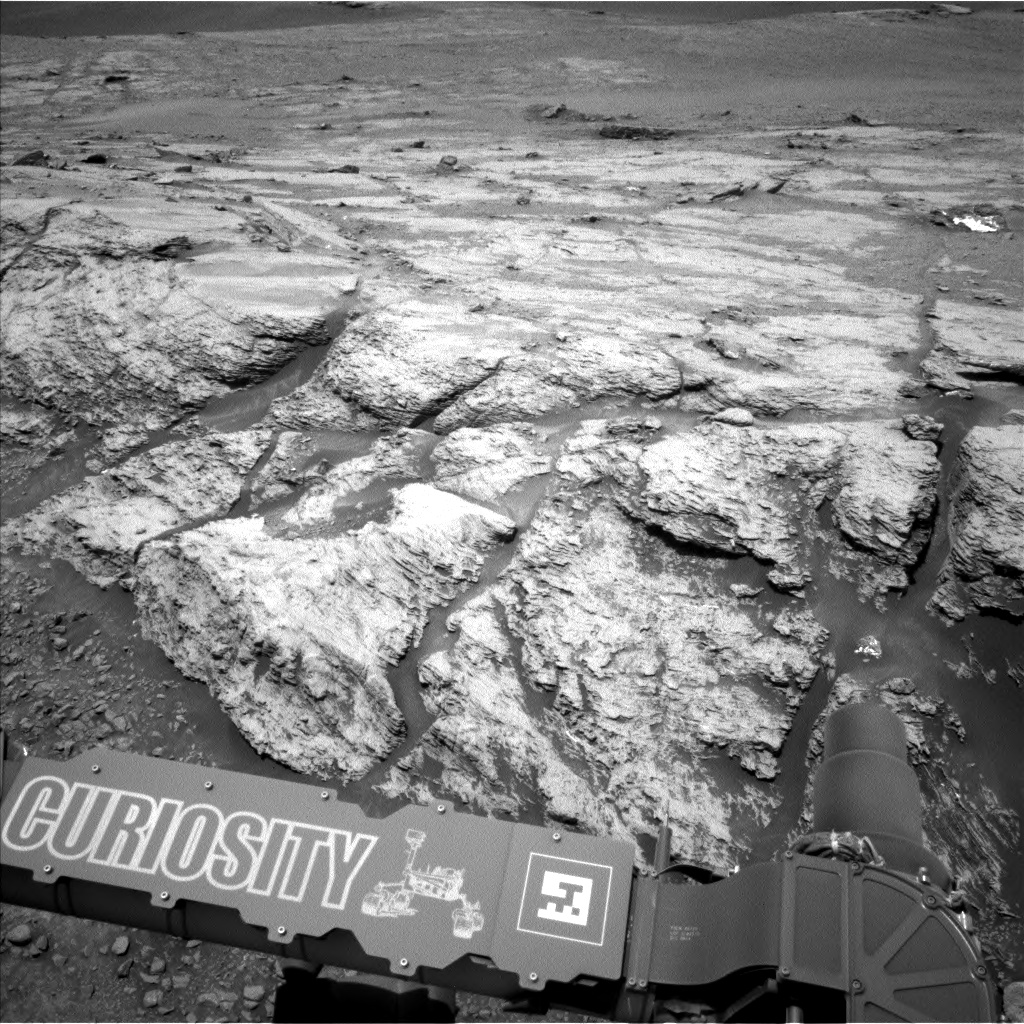
Curiosity is parked in front of a ridge-forming outcrop known as "Harlaw" in the Glen Torridon region, and the team had some fun with naming targets today. While planning contact science to investigate a rough, potentially nodular face of the outcrop, the Geology group decided to use the name "Badcall," which definitely raised some eyebrows during the planning process. The target is actually named after Badcall Bay on Earth, which exposes some of the oldest rocks in Western Europe. So hopefully this observation turns out well!

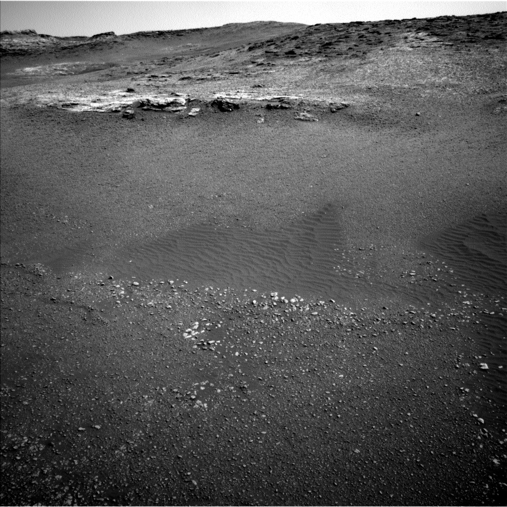
I was the SOWG Chair today, and it was a late slide sol, which means we started our day 3.5 hours later than normal in order to get some data downlinked in time for planning. The focus of this plan is to investigate the grain size, stratification, and composition of the ridge-forming outcrop shown in the above Navcam image. The plan starts with a Mastcam mosaic to investigate stratification in the slope ahead of us, followed by ChemCam on the targets "Tayside," "Badcall," and "Buckie." The plan also includes some environmental monitoring observations to characterize the amount of dust in the atmosphere. Late in the afternoon we'll use the DRT to remove dust from the "Buckie" target before imaging it with MAHLI. We also planned MAHLI observations of "Badcall." Then we'll use APXS to investigate the chemistry of both "Badcall" and "Buckie" in the evening and overnight. We'll stay at this outcrop for part of the weekend plan, so we have a few more opportunities to characterize this area and how these structures might have formed.

June 28, 2019

Sols 2451-2453: Climbing Higher

Written by Roger Wiens, Geochemist at Los Alamos National Laboratory
Sols 2451-2453: Climbing Higher

Curiosity has been a bit down lately-in elevation. After exploring the top of Vera Rubin Ridge (VRR) last year, the rover descended into a trough south of the ridge, dropping as much as 15 meters in elevation this spring to explore part of the clay-bearing unit. Curiosity is now back to the highest elevation that it achieved before it left the ridge, about -4140 meters relative to the reference level representing zero elevation on Mars. The image shows the rim of the crater once again visible above Vera Rubin Ridge. Curiosity will continue to climb higher as it explores the rest of the Glen Torridon and then moves on to the sulfate unit and Greenheugh Pediment.

The reference level for Mars elevation is the mean of its areoid, as measured by altimetry and gravity measurements. The pressure at this elevation is very close to the triple point of water, where stability fields of liquid, ice, and vapor come together. In fact, Mars' areoid was at one time based on the elevation where the atmosphere was at the triple point of water. However, it is easier to define this elevation from gravity and altimetry data.

Today the rover team planned activities for the rover over the weekend. Curiosity is wrapping up activities at the base of "Harlaw Rise" and will then drive further up the rise. On the first sol of the weekend plan the rover will mostly nap to recharge batteries. Some Hazcam imaging will be done and Mastcam will take some nighttime images. On the second sol, ChemCam will shoot three targets near the rover: "Red_Point" (same block as yestersol's "Tayside" target), "North_Sea," and "Roineva." Mastcam will take a crater rim extinction image. The arm will be deployed for imaging of these gnarly rocks with MAHLI and analysis with APXS. Target names are "Earn" (below yestersol's "Buckie" target) and "Magnus_Bay" (same block as "Tayside" and "Red_Point"). The following morning Navcam will take zenith and superhorizon movies, and Mastcam will take another crater rim extinction image. Later in the day Mastcam will image "Harlaw_Rise" and the "Tayside" and "Buckie" targets. After that it will do some deck monitoring; Navcam will do a 360 degree dust devil survey. The rover will drive 35 meters, which should take it up "Harlaw Rise." Images will be taken to set up for Monday's plan.

June 27, 2019

Sol 2449: Keep on rollin' through the rubble to "Harlaw"

Written by Lucy Thompson, Planetary Geologist at University of New Brunswick
Sol 2449: Keep on rollin' through the rubble to "Harlaw"

Navcam left image of "Harlaw," an exposed area of bedrock (upper portion of the image) that we are planning to drive to in this plan.

We are continuing our exploration of Glen Torridon (the clay-bearing unit) and the varied lithologies exposed in this area of Gale crater, including more rubbly bedrock that is mixed with sand, and more coherent bedrock exposed both in the ground and capping prominent ridges. Curiosity continued the drive away from one of these ridges, Teal Ridge, towards another low-lying lip and ridge of exposed bedrock that we are referring to as "Harlaw." The drive in yestersol's plan put us about 9 m away from Harlaw and in a perfect position to get some context Mastcam mosaics of the area that will help us interpret the results of our planned closeup investigation of this area.

Before the planned drive towards Harlaw in tosol's plan, we will examine the rubbly ground immediately in front of the rover, using APXS, MAHLI, ChemCam and Mastcam. We will get a short morning APXS integration, closeup MAHLI images and ChemCam on a target "Tolsta," ChemCam only on a target "Yell Sound" and accompanying Mastcam imaging of the workspace to continue monitoring the composition and texture of the rubbly bedrock as we traverse the Glen Torridon region.

Environmental observations included standard background REMS activities to monitor the daily martian weather, RAD to monitor the radiation environment and DAN passive to study the abundance and distribution of subsurface hydrogen- and water-bearing materials. A Navcam dustdevil survey and suprahorizon movie are also included. The suprahorizon movie will look for clouds and the optical depth of the atmosphere.

As well as monitoring activities to write this blog today, as the APXS strategic planner for this week, I helped pick the "Tolsta" target this morning and prepared our weekly instrument update for the science team.

June 25, 2019

Sol 2447: Making a Lien List, Checking it Twice

Written by Scott Guzewich, Atmospheric Scientist at NASA's Goddard Space Flight Center
Sol 2447:  Making a Lien List, Checking it Twice

Today's plan wrapped up our time at the Teal Ridge outcrop and we'll begin to drive toward the next waypoint in the clay-bearing unit of Gale Crater. We had several science tasks on our lien list to complete first, including ChemCam LIBS targets on the "rubbly" material in front of the outcrop (we identified a target named "Glencoe"), one on a dark vein structure within the outcrop (termed "Glenbuchat," some of the incredible layered structure in Teal Ridge can be seen in this MAHLI image), and then a Mastcam multispectral image (where Mastcam uses its different filters to get a better understanding of a rock's chemistry) of the "Beauly" target that received a thorough cleaning with the dust removal tool last week.

After the drive, we'll be about halfway to our next waypoint and we'll stop to conduct some post-drive science including imaging of the surrounding area and some late afternoon ENV activities including a Mastcam sky survey (to help understand the properties of the airborne dust) and a Navcam zenith movie to search for clouds. The "Aphelion Cloud Belt" season is nearly upon us and we expect the skies to be getting much cloudier in the sols and weeks ahead.

June 25, 2019

Sol 2448: Very Small Rocks

Written by Ryan Anderson, Planetary Geologist at USGS Astrogeology Science Center
Sol 2448: Very Small Rocks

Our drive on Sol 2447 stopped a bit short, placing us on an area that was mostly gravel. Nothing against gravel, but we are eager to get to the outcrops ahead of us, so we went with a pretty light plan for today to allow more time and energy for driving. We start off with a ChemCam observation of a pebble dubbed "Strathclyde," followed by Mastcam of the same target. Then we have a Mastcam mosaic of the upcoming outcrop. After the drive we have all the usual post-drive imaging, including a MARDI image of the ground beneath our wheels. We originally had a ChemCam autonomously targeted observation, but that was pulled to save power for tomorrow. We will wrap up Sol 2448 with a twilight Mastcam movie to watch for clouds.

June 24, 2019

Sols 2444-2446: The View from Teal Ridge

Written by Kristen Bennett, Planetary Geologist at USGS Astrogeology Science Center
Sols 2444-2446: The View from Teal Ridge

Curiosity is still perched on top of Teal Ridge to investigate a fascinating outcrop that caps the ridge. The above Navcam image shows the view off to the right of Curiosity. The ridge-capping material is visible in the foreground, and the background shows where Curiosity is going to drive to next. We are spending part of the weekend characterizing the ridge-capping material, but a majority of the weekend plan will be devoted to SAM activities to look for methane.

The first sol of this three-sol plan includes a MAHLI dog's eye mosaic of the target "Stack of Glencoul." Typically the arm is positioned such that the MAHLI instrument is looking down on a target. In a dog's eye observation, the rover arm is positioned so that it looks at the target from the side. The team decided we should do a dog's eye mosaic at this location so we can look directly at the laminations within these rocks. APXS will also target Stack of Glencoul in the weekend plan so we will be able to pair compositional information with these images. MAHLI will also take images of the "Yesnaby Stacks" target to document a different part of the outcrop that exhibits laminations.

Also included in the plan are a Navcam dust devil movie, Mastcam images of the "Sandyhills" target to monitor changes due to wind, a ChemCam observation of Yesnaby Stacks, and an addition to the "Beauly" Mastcam mosaic to complete our Mastcam coverage of this outcrop.

The SAM instrument is also featured prominently in this weekend's plan. The team is using SAM to periodically search for methane in the atmosphere, so SAM will "sniff" the air during the night on the second sol and then spend part of the weekend analyzing this sample of the martian atmosphere.

June 20, 2019

Sol 2443: Brushing Beauly and beholding Balnakettle

Written by Abigail Fraeman, Planetary Geologist at NASA's Jet Propulsion Laboratory
Sol 2443: Brushing Beauly and beholding Balnakettle

MAHLI observation of Beauly

Curiosity is still parked at a tilt of a little over 23˚ to examine the outcrop on top of "Teal Ridge." While the science team begins to pore over all the data that came down yesterday and today, we also simultaneously developed a busy plan for today that will continue our investigation of this spectacular sedimentary outcrop.

The main activities in the sol 2443 plan will be a DRT, MAHLI, and APXS observation of a finely layered target named "Beauly," which was imaged with MAHLI on sol 2441. We will also take a MAHLI and APXS observation of a second target named "Balnakettle." Outside of the contact science observations, Curiosity will take two change detection images of a target called "Sandyhills," and a 10x2 stereo Mastcam mosaic towards an area Curiosity will be driving through soon that the team has informally dubbed the "Visionarium" in anticipation of the bedrock exposures that will be visible. We also have a Mastcam 11x6 stereo mosaic to completely document the area around Beauly, and we will collect a 1x10 ChemCam LIBS observation of target named "Bower." Curiosity will even squeeze in some environmental science observations with Navcam suprahorizon and zenith movies.

June 19, 2019

Sol 2441-2442: So much to do before the Holiday

Written by Ashley Stroupe, Mission Operations Engineer at NASA's Jet Propulsion Laboratory
Sol 2441-2442: So much to do before the Holiday

Curiosity is still parked on Teal Ridge and is in the midst of an extended contact science campaign. This ridge location, shown in the attached image over Curiosity's shoulder, is exciting because it shows crossbedding in a bedrock layer, as well as a contact between the bedrock outcrop and a rubbly layer below. We hoped to use the DRT to remove dust, but we still didn't have Mastcam workspace imaging to support DRT use on the bedrock. Happily, we were able to reach some of the rubbly material that we previously thought we'd have to bump to. We picked two contact science targets - "Urr" (rubbly) and "Calgary Bay" (cap unit of the ridge); we planned MAHLI and APXS on both.

In addition to contact science, we're doing remote sensing with ChemCam and Mastcam on Calgary Bay and another cap unit target called "Irvine." There is also a lot of ENV imaging in the plan, including change detection (which will continue into the next plan) on Sandyhills. Also part of our ENV campaign, we included a coordinated suite of observations including a SAM methane experiment, ChemCam sky imaging, Mastcam tau, crater rim extinction, and a Navcam dust devil survey.

As the Supra-Tactical Lead today, I am also looking ahead to the rest of this campaign. DRT and MAHLI dog's eye will likely be in our next plan in order to get a more dust-free APXS observation and to get a low-angle look at the crossbedding visible in the Mastcams. We'll be continuing contact and targeted science at this location until we drive away, presently scheduled for the middle of the weekend plan.

June 17, 2019

Sol 2440: Retransmit, please!

Written by Dawn Summer
Sol 2440: Retransmit, please!

Curiosity's most recent transmission didn't come down as expected, so our plan today is to command the rover to retransmit its latest data. That includes where it ended up after its drive this weekend. We still spent the morning planning. Because we were missing key data about exactly where Curiosity is, we could not implement our planned MAHLI and APXS analyses. Rather, we focused on "untargeted" observations, which don't require knowing Curiosity's exact location. The team planned regular weather observations, a survey of the sky at twilight, a movie looking for dust devils and a second one looking up at the clouds. We also planned a 360° Mastcam image to capture the regional outcrops as well as three ChemCam AEGIS analyses, where the instrument automatically selects targets within a region defined by the team. We also asked Curiosity to retransmit detailed location and image data so that we can plan our contact science tomorrow. The outcrop in front of us is spectacular - we should be right in front of the rocks shown in the image above!

June 14, 2019

Sols 2437-2439: An oasis of rock in a sea of pebbles

Written by Catherine O'Connell-Cooper, Planetary Geologist at University of New Brunswick
Sols 2437-2439: An oasis of rock in a sea of pebbles

The ridge, with Mount Sharp in the background

We are investigating the ridges which are such a prominent feature in this section of Glen Torridon. The ridges appear to be composed of sand and pebbles, capped with layered bedrock (see image above). The Rover Planners (RPs) at JPL assessed the ridge imaged, known as "Teal," and gave a GO for driving up onto it. We broke the ascent into two drives, aiming to get halfway in yestersol's plan (sol 2436) and the rest of the way in this weekend's plan. The RPs got us exactly to where we wanted to be for this plan, and we ended up on a very small outcrop of more coherent bedrock, surrounded by pebbles and sand.

Those of us in the Geology theme group (GEO) were very excited to find ourselves here, as this is the most substantial piece of bedrock we have seen this week. APXS will analyze the "Iapetus" target on the bedrock, and do a 2-point raster "Almond" across small grey pebbles and sand. The rover was too close to Iapetus to allow ChemCam to shoot it with the LIBS laser without danger to the rover, so ChemCam focused on documenting pebbles here, looking at the targets "Angus," "Braan," and "Tweed." A Mastcam multispectral image, using multiple filter types, will examine spectral variability of the pebbles and sand between Tweed and Almond.

Before climbing up onto the ridge, Mastcam will take some colour imagery, looking at the rubbly material in the lower part of the ridge, and documenting the transition from the rubbly material to the capping material.

Our drive will hopefully take us to the bedrock in the left-hand side of the image. Once there, we will acquire imagery (Mastcam and Navcam) of our new workspace and future drive direction, to be ready for a full week of exploration on top of this ridge when we come back after the weekend. Mastcam will also get a post-drive image of the workspace under one of our wheels, as part of a long-running observation of bedrock, pebbles, and soils along our traverse.

The Environmental theme group (ENV) planned paired Mastcam observations for each sol of the plan, to determine the amount of dust in the crater ("crater rim extinction" measurements) and to measure the optical depth of the atmosphere and constrain aerosol scattering properties ("full tau" measurements). The Rover Environmental Monitoring System (REMS) will acquire hourly temperature, pressure, humidity, and UV radiation measurements. DAN (Dynamic Albedo of Neutrons) continues its search for subsurface hydrogen, with frequent passive (utilizing cosmic rays as a source of neutrons to measure hydrogen) and post-drive active (actively shooting neutrons from the rover) measurements. Finally, ENV planned a number of movies, used to document clouds and dust devils. "Zenith" cloud movies look upwards, whilst "suprahorizon" movies look at clouds and variations in optical depth in a more horizontal direction. Dust devil movies can give information on surface heating and winds near the surface.