June 9, 2017

Sols 1722-1724: Leftovers for Dinner

Written by Scott Guzewich, Atmospheric Scientist at NASA's Goddard Space Flight Center

Today, as I served as the Science Operations Working Group Chair, we prepared a 3-sol duration plan to keep Curiosity busy over the weekend. Almost the entirety of the first two sols (1722 and 1723) are dedicated to a SAM analysis of a "doggy bagged" sample from the Quela drill hole collected back in September 2016 (Sol 1464). Several times in the mission we’ve saved samples from our drill locations to analyze later. This SAM analysis will help us determine the precise chemical composition of the martian bedrock and therefore improve our understanding of ancient martian history!

This image was taken by Navcam: Left B (NAV_LEFT_B) onboard NASA's Mars rover Curiosity on Sol 1721 (2017-06-09 12:08:15 UTC).
On the third sol of our plan (1724) we planned ChemCam and Mastcam observations of a bedrock target termed "Old_Point" (the flat light-toned rock just below the ripples in the image to the right). ENV also scheduled an early morning science block on Sol 1725 before we begin that sol’s plan. These morning activities help us understand how atmospheric conditions change at different times of day, for example, how the clouds and dust in the atmosphere vary between morning and afternoon.

June 8, 2017

Sol 1720: Rough Road Ahead

Written by Christopher Edwards, Planetary Geologist at Northern Arizona University

I was the Surface Properties Scientist, or SPS on staff today. The SPS has an interesting job, in that the SPS helps Rover Planners (called RPs) assess the terrain around the rover with safety in mind, first and foremost.

There are two main jobs of an SPS. The first is to assess how likely the rover is to slip in its current position, called the Slip Risk Assessment Process (SRAP). Is it on a stable footing, like thin sand cover over smooth rocks, or is a wheel perched on a ledge? The reason this is important is because as MSL's arm is articulated to conduct contact science, a perched rover wheel might slip and cause damage to the arm by contact between the turret and the ground. That would be bad! Today we were on a solid surface and passed SRAP without any concerns.

The other job of the SPS is to help the RPs find a safe path forward if there is a drive planned. On some sols this is a very taxing job, other days not so much. Today was in the middle. The RPs use high resolution digital terrain models generated from imagery taken from the previous sol after the latest drive to plan a safe path to the next stopping point, while avoiding rocks, ledges, and deep sand. The RPs confer with the SPS to evaluate the proposed route making any modifications necessary along the way. Today, the path directly ahead was pretty rough, so the drive was planned to dodge some angled rocks, and head back towards the Mount Sharp Ascent Route and ultimately the Vera Rubin Ridge.

June 8, 2017

Sol 1721: An easier planning day

Written by Ken Herkenhoff, Planetary Geologist at USGS Astrogeology Science Center

MSL drove 26 meters on Sol 1720, as planned, to a location with blocks of bedrock in the arm workspace. Because the rover climbed another 3 meters in elevation, contact science has top priority for today's plan, with driving next in priority. One of our strategic goals is to measure the chemistry of Murray formation rocks using APXS at elevation intervals of no more than 5 meters. So the GEO science theme group (STG) selected a smooth, typical Murray bedrock target named "Fawn Pond" as the top priority for contact science (APXS and MAHLI observations), and planned ChemCam and Right Mastcam observations of nearby target "Kief Pond." The GEO plan also includes a 6x2 Right Mastcam mosaic to investigate sedimentary structures at "Arey Cove" and standard post-drive imaging.

This image was taken by Navcam: Left B (NAV_LEFT_B) onboard NASA's Mars rover Curiosity on Sol 1720 (2017-06-08 11:40:16 UTC).
The ENV STG requested non-standard RAD activities that required lengthening the post-drive science block. Despite concerns about power, all of these science activities fit nicely into the plan! I'm SOWG Chair today for the third day in a row, and it's been the easiest shift so far: There were no delays in processing the new data needed for planning this morning, and the volume of data expected to be returned in time for planning tomorrow is comfortably larger that it was on Sols 1719 and 1720.

June 6, 2017

Sol 1719: Wait and Hurry Up!

Written by Ryan Anderson, Planetary Geologist at USGS Astrogeology Science Center

Today was an interesting day of planning: because of an issue with the computer system responsible for processing data once it is received on Earth, Curiosity's images and other data from Sol 1718 didn't arrive until well into today's planning. That meant that we had to keep the plan simple and respond rapidly once the data did arrive. It also meant that we had plenty of time to choose our favorite target names from the list!

Once the data started rolling in, we quickly chose a nice piece of bedrock in front of the rover for APXS and MAHLI to analyze and gave it the target name "Aunt Betsey's Brook". We also planned a ChemCam observation of a flaky layered rock called "Wonsqueak Harbor" and a small Mastcam mosaic of a block of layered bedrock called "Little Round Pond". After that, Curiosity will drive about 16 meters and collect post-drive imaging for targeting. After the drive we'll also take a Mastcam image of the ground near the rover (part of the ongoing campaign to systematically look at the terrain we're driving over), Mastcam images of the sun and the distant crater rim to study dust in the atmosphere, and an automatically targeted ChemCam observation. The plan will wrap up with the usual evening MARDI image of the ground under our wheels.

In the end, despite the delay in planning, we managed to put together the plan and turn it in early! We joked that we can't keep being so efficient every day or else we'll give the impression that we don't need our full planning time anymore!

June 5, 2017

Sols 1718: Looking East

Written by Scott Guzewich, Atmospheric Scientist at NASA's Goddard Space Flight Center

We are beginning to turn toward the east and southeast as we approach Vera Rubin Ridge with the Curiosity rover. After a busy and successful plan over the weekend, we weighed our priorities between using APXS to study the bedrock we're driving over or drive farther along our path.

Today I was the Science Operations Working Group Chair as we planned sol 1718 and since we had only gained ~3m of elevation in our last drive, we decided to forgo contact science with APXS in favor of extending our drive distance. The GEO science theme group still found some interesting bedrock-"East Point" (the dark section in the middle of the rock at the upper right corner of the image), "East Pond", and "Eastern Point Harbor" - to target with ChemCam and Mastcam before we begin our drive. After a ~26 meter drive, we planned post-drive imaging to prepare for the next sol's activities and conducted a ChemCam AEGIS activity. The ENV science theme group had a quiet plan with routine DAN and REMS observations.

June 5, 2017

Sols 1715-1717: If it's worth doing, it's worth doing right

Written by Michelle Minitti, Planetary Geologist at Framework

Curiosity left no stone unturned, unshot or unbrushed as she wrapped up observations at the stand of gray-toned rocks she arrived at on Sol 1712. We added to yesterday's rich observations of gray-toned rocks by brushing a nodule-rich target, "Timber Point," to give MAHLI and APXS as clear a look as possible of the target's texture and chemistry. We added to yesterday's rich observations of gray-toned rocks by brushing a nodule-rich target, "Timber Point," to give MAHLI and APXS as clear a look as possible of the target's texture and chemistry. Scattered amongst the gray-toned rocks were patches of Murray formation rocks, and the team thought it best not to neglect our old friend. MAHLI images and APXS data from the Murray target "Old Mill Brook" will complement all the data we have collected from the gray-toned rocks. Both Timber Point and Old Mill Brook were also accessible to ChemCam, which will shoot both these targets before MAHLI has a look at them. This gives MAHLI a unique chance to look at the laser-disturbed material within each ChemCam spot, which can reveal more about the grain structure of the target than an observation of an undisturbed surface. ChemCam also analyzed a second Murray target, "Goose Eye Mountain," to expand our dataset on this material, and a beautifully-layered, gray-toned target called "Spectacle Island." We accomplished most of our Mastcam imaging of the outcrops around us yesterday, but additional Mastcam imaging of Spectacle Island was just too good to pass up.

Curiosity will also acquire a variety of images and movies of the skies. Taken in the early morning and later in the afternoon, they will help us understand the dynamics of the atmosphere over the course of the Martian day. SAM will prep for its next atmosphere measurement, as well.

After all this activity, Curiosity will drive away from our gray rock playground, for new discoveries uphill!

June 1, 2017

Sol 1714: Let's try that again

Written by Lauren Edgar, Planetary Geologist at USGS Astrogeology Science Center

Unfortunately the Sol 1713 activities were not uplinked due to an issue at the DSN station, so today's plan is focused on recovering the activities that were planned yesterday. The good news is that we’ll be in the same location for the start of the weekend plan, so we’ll be able to add some additional contact science targets at this interesting site.

I was the SOWG Chair today, and it was a pretty straightforward planning day since it was mostly a repeat of yesterday! The plan kicks off with Mastcam mosaics of "The Whitecap," "Trap Rock," and "Pond Island" to document some nearby sedimentary structures. Then ChemCam will target "Heron Island" and "McNeil Point" to investigate variations in chemistry within the darker gray rocks in this area. We’ll also acquire a ChemCam RMI to assess the grain size and stratification at "Sols Cliff." Then Navcam will carry out a dust devil survey to monitor atmospheric activity. Slightly later in the afternoon, we’ll acquire a Mastcam mosaic to document the contact science target "Prays Brook" and surrounding rocks, and we’ll take a multispectral observation on "Heron Island." The meat of the plan lies in the contact science: APXS and MAHLI observations on "Berry Cove" and "Heron Island" to assess the darker gray rocks both with and without nodules, as well as a dog’s eye MAHLI mosaic along "Prays Brook" to characterize the contact between the dark gray rocks and the underlying typical Murray formation. It’s a juicy plan so I hope it all goes smoothly this time, and we’re looking forward to more contact science tomorrow before we hit the road to Vera Rubin Ridge.

For more information about Curiosity’s investigation of the Murray formation and the ancient lake environments that it records, check out this recent press release:
https://mars.nasa.gov/news/2017/curiosity-peels-back-layers-on-ancient-martian-lake

May 31, 2017

Sol 1713: Not enough hours in the sol

Written by Abigail Fraeman, Planetary Geologist at NASA's Jet Propulsion Laboratory

Tosol on Mars was one of those sols where we simply did not have enough hours to get everything done that we had wanted to do. Our Tuesday drive placed us perfectly in front of a very interesting outcrop that looked slightly different in color and texture from the typical Murray rocks we’ve been seeing for the last few hundred meters. We had originally thought we would spend the morning doing contact science on this outcrop and then drive away in the afternoon, completing everything before the Mars Reconnaissance Orbiter flew overhead and it would be time to call home. However, when the downlink came in this morning, the science team found there was a lot we wanted to look at that was accessible in our workspace. The rover drivers also reported that the route ahead was clear and we would be able to do a nice long drive. With all of these options but a limited amount of time available before the orbital pass, we concluded it would be best to plan to spend all of the sol doing science on the outcrop, and then wait until tomorrow to drive away.

The geology theme group certainly took advantage of the unexpected extra time for science, and filled the plan with lots of remote sensing and contact science activities. We planned to take APXS observations of two targets on gray-toned rock targets named "Berry Cove" and "Heron Island," as well as MAHLI observations of both of these targets plus an additional target at the contact between a red and gray rock named "Prays Brook." We’ll complement all that with ChemCam observations of gray rock targets named "Spectacle Island," "McNeil Point," and Heron Island, plus associated Mastcam imaging to support the ChemCam observations. We’ll also be getting even more Mastcam images of interesting surrounding rock targets "The Whitecap," "Trap Rock," and "Pond Island," and a ChemCam remote micro-imager (RMI) mosaic of target "Sols Cliff." Finally, we’ll also be doing our standard background REMS and DAN passive observations to monitor the environment. Whew! It should be a great day of doing science on Mars.

May 30, 2017

Sol 1712: Eyes on the prize

Written by Michelle Minitti, Planetary Geologist at Framework

Despite the holiday weekend, the science and engineering teams were greeted with a plethora of data from Curiosity when they started planning Sol 1712 - like your birthday and your favorite winter (gift-getting) holiday rolled into one. The science team had beautifully illuminated MAHLI images of the unique texture of our weekend targets "White Ledge" and "Patty Lot Hill," loads of ChemCam and APXS data from rocks and soils, and new atmospheric measurements courtesy of SAM, ChemCam, Navcam and Mastcam. The engineers had new drill diagnostic data, which will help them learn ways to get the drill back in use. Getting to put Curiosity right back to work after receiving such an embarrassment of riches makes for one grateful team.

The bedrock in front of the rover resembled the Murray formation bedrock we have seen over the last week or so, so the science team did not feel the need to acquire MAHLI and APXS on it before driving away. Instead, the team eyed an outcrop of gray toned, layered rock about 10 m to the south.

We have seen this type of gray-toned rock before, which differs in chemistry and texture from the Murray formation, but have had little luck accessing it for contact science. To further understand how and why this outcrop differs from the Murray, the team asked the rover planners to drive us to the outcrop for a touch-and-go on it with MAHLI and APXS in the plan tomorrow. While the rover planners could have driven to a point ~15 m past the gray outcrop, the team felt the opportunity to reach out and touch this rock was worth driving a little bit less than was possible today. We will all have our fingers crossed for a successful drive!

Before heading down the road, we acquired ChemCam data from two targets, "Ned Island" and "Ravens Nest," both of which will add to our Murray formation dataset as we climb Mt. Sharp. We kept tabs on the dynamic environment around us by acquiring REMS and RAD measurements, Mastcam images of dust in the atmosphere, and Mastcam images of changes in sand blown onto the rover deck. All told, it was a successful start to what should be another great week in Gale Crater!

May 26, 2017

Sols 1709-1711, "White Ledge"

Written by Roger Wiens, Geochemist at Los Alamos National Laboratory

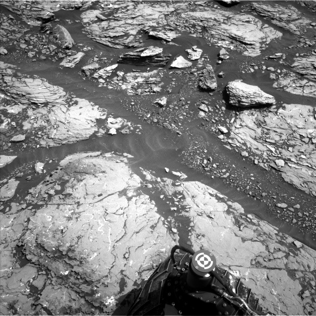
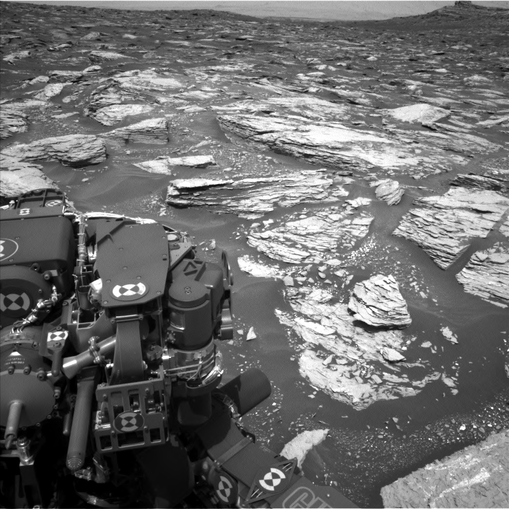
Curiosity continues to drive through an otherworldly jumble of in-place bedrock, tilted rocks, sand with small ripples, and local pebbly debris piles. Vera Rubin Ridge continues to loom larger in the rover’s forward view, although progress is somewhat slow due to the difficult terrain. Yestersol’s drive was 16 meters.

Just 20 sols ago we passed the northern vernal equinox, but the rover is ‘down under’ (at 4 degrees south latitude), so we’ve just started the fall season. For those readers in the Earth’s northern hemisphere, it’s like about October 1 on Earth. Over the next half of a Mars year (or nearly one Earth year) the rover will have a little less power for driving, arm deployment, and instrument activities as it spends a little more energy keeping itself warm. The body of the rover is kept warm by a fluid loop that distributes heat from the radioisotope thermoelectric generator (RTG) to the rover body, but the extremities (arm, wheels, and mast) need to be heated electrically. As a result, the rover will take one day to recharge its battery this weekend. It’s a holiday weekend in the US and much of Europe, so why shouldn’t Curiosity have a day off too?

We also have a soliday, but that’s not a rover holiday, in fact, it’s not a day on Mars at all. Rather, it’s an extra day we have on Earth every 37 Mars days due to the shorter day on Earth. So Mars has one less day for this holiday weekend. All told, the rover will be working two days this weekend.

As I write today’s Mars blog post, we are finishing the science operations working group (SOWG) meeting, arranging the plan. We have a beautiful "White Ledge" right in front of the rover, and so we decided to spend these two Mars days doing lots of analyses. We are interrogating the ledge with two different arm placements, an evening APXS integration on a location named "Patty Lot Hill," and a night integration on "White Ledge" after using the dust removal tool (DRT). MAHLI takes images of these targets the following sol. We are taking extra precautions in case the rather thin ledge breaks when we place the arm on it. We are also interrogating the ledge with Mastcam and ChemCam. Other ChemCam targets include "Shooting Ledge" (a rocky ridge just behind "White Ledge"), "Middle Ledge" behind and to the left, and "Halfway_Mountain", a sand ripple crest. SAM is doing an atmospheric measurement, and REMS and RAD are taking measurements this weekend too, so it is an "all-instruments" weekend except for CheMin.

At the end of the second sol Curiosity drives to a good vantage point (< 20 m). We also managed to slip in Mastcam sun observations and a ChemCam sky spectral observation on Tuesday morning (Sol 1712) before the next uplink of activities from Earth.