May 25, 2017

Sols 1707-1708: When Mars Gives You Lemons, Calibrate Your Instruments

Written by Michael Battalio, Planetary Climatologist at Yale University
Sols 1707-1708: When Mars Gives You Lemons, Calibrate Your Instruments

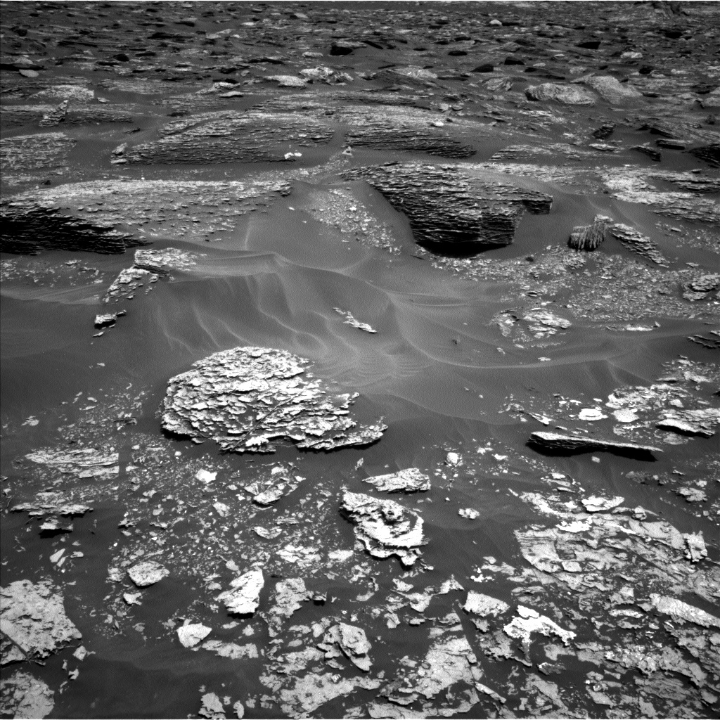
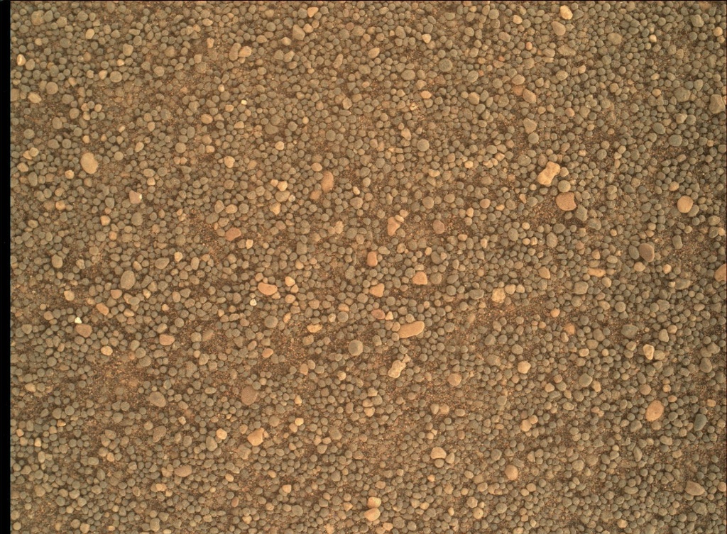
After a 14.6 m drive, the GEO group decided against arm activities due to a lack of compelling targets and in deference to making the next drive longer. Thusly, GEO science activities relied on Mastcam and ChemCam. On Sol 1707, ChemCam will capture a raster of the "White Cap Mountain" bedrock target (the white bedrock left of center in the bottom quarter of the above Navcam image), as well as a patch of dark undisturbed soil called "French Hill Pond." Mastcam will document all of the ChemCam targets and will image "Googings Ledge" (the large, darker bedrock just above and right of image center) and "The Twinnies" (the shadowed bedrock exposure cut off on the far left), which are sedimentary members of the Murray formation, and "Soward Island," which has exposed bedrock layers. After a planned 30 m drive, ChemCam will perform an AEGIS automated activity, and Navcam will document Curiosity's new position. SAM will perform a methane dual enrichment activity on Sol 1709, which will compare a methane-enriched atmospheric sample to a non-enriched sample.

I served in the ENV STL role, and today was one of the more hectic ENV operations days I have planned. It was a plan full of trade-offs. When SAM takes atmospheric methane or oxygen measurements, ENV likes to obtain a ChemCam passive sky observation within a few sols for an independent comparison. However, the times initially available in the plan around mid-sol to place a passive sky were not compatible with possible pointing azimuths, as we are so close to the new year (northern hemisphere spring equinox). In anticipation of potential power restrictions in the weekend plan, we attempted a long morning imaging suite a couple of sols early, which would include a passive sky measurement; however, we were forced to defer those plans due to power restrictions in the current plan. Instead of losing the science time altogether, we noticed that the mid-sol time was compatible for taking a ChemCam calibration measurement. This calibration will be taken on Sol 1708 in preparation for the next passive sky. This just proves that while doing science on another planet can be frustrating at times, it is always rewarding.

On top of the ChemCam calibration, the ENV group planned several Mastcam and Navcam observations. On Sol 1707, Mastcam will capture tau and LOS measurements to assess the amount of dust in the atmosphere. Also on Sol 1707, Navcam will capture a late afternoon zenith cloud movie. A 30-minute Navcam dust devil movie will be taken around noon on Sol 1708. REMS will capture the standard top of the hour 5 minute observations and 19 hour-long observation blocks, which will include observations during the ingest times of the SAM methane activity. DAN will take approximately 9 hours of passive and 20 minutes of post-drive active observations.

May 22, 2017

Sols 1702-1704: An island of science

Written by Michelle Minitti, Planetary Geologist at Framework

The rover planners parked us in front of the one slab of outcrop - an island among ripples of sand - we could safely drive to from our Sol 1700 position, setting us up to continue our exploration of the Murray formation.

The outcrop slab exhibited color variations (gray, pink and orange) and patchy white veins, so to capture these variations the science team analyzed multiple spots on the outcrop with MAHLI, APXS, ChemCam and Mastcam. We brushed dust off the target "Fern Spring" with the DRT and analyzed two separate spots within this dust-cleared area with APXS. Getting two closely spaced APXS targets makes it easier to pull apart compositional variations within the outcrop than a single APXS analysis alone. We planned a ChemCam raster over Fern Spring to be able to compare the compositional results from APXS and ChemCam, and a second, similar target, "Redfield Hill" to maximize the amount of data from the bedrock. Another target that got attention from both APXS and ChemCam was "Pulpit Ledge", so named because this gray-toned area of outcrop appeared perched above the rest of the outcrop surface. The gray color of Pulpit Ledge set it apart from the more orange-red color of Fern Spring and Redfield Hill, and the science team hoped to gain insight into why these parts of the outcrop were different in color by looking at these distinct targets. We looked at another gray outcrop area, "Broad Cove", using the passive mode of ChemCam and the multispectral capability of Mastcam. Both these techniques assess the spectrum of light reflected from the target surface, which provides insight into the iron mineralogy of the target. Each APXS target was imaged with MAHLI, to not only help inform APXS of exactly what part of the outcrop they obtained data from, but to look closely at the texture and grain size of the targets. Looking out past the outcrop immediately in front of us, Mastcam acquired small mosaics of two separate areas of dramatically layered Murray formation. Such large, layered blocks make driving through this part of the Murray formation a challenge, but they help the science team understand how the Murray formation rocks were deposited in Gale crater.

Curiosity cast her gaze skyward over the weekend acquiring images and movies seeking clouds and dust devils, and monitoring the amount of dust in the atmosphere. Measurements of dust in the atmosphere not only provide insight into atmospheric behavior, they help the science team decide when to image distant objects such as Vera Rubin Ridge. The more dust in the atmosphere, the harder it is to see such objects. The rover also prepared for an important upcoming atmospheric analysis, a SAM measurement of atmospheric methane.

May 22, 2017

Planning Sol 1705 - 1706: Rocky Road

Written by Abigail Fraeman, Planetary Geologist at NASA's Jet Propulsion Laboratory

Curiosity is continuing to make progress towards Vera Rubin Ridge along the Mt Sharp ascent route. We planned two sols today, Sol 1705 and Sol 1706. On our first sol, we will kick off the day with some remote sensing science on the bedrock in front of us, including ChemCam observations of targets "Turtle Island", "Stony Brook", and "Dike Peak". Turtle Island is typical Murray bedrock, Stony Brook has an interesting dark streak running through it, and Dike Peak is a neat looking block with dark colored fracture fills. We will complement these observations with Mastcam documentation imaging. We’ll then go for a short drive and take some post drive imaging and a ChemCam AEGIS observation. On the second sol of the plan, Curiosity will be focused on taking atmospheric observations, including a dust devil search and images of the crater rim and sky above us.

We didn’t drive as far as we thought we would over the weekend. Software onboard Curiosity sensed the rover was struggling to travel over the challenging terrain more than we had anticipated, so it ended the drive early. Because I was staffed as a Surface Properties Scientist (SPS) during planning today, I spent most of my time on shift looking at the Navcam and Hazcam data to understand what about the terrain was causing problems, and thinking about new paths to take that would still get us where we wanted to go. I’m optimistic about our new drive route, and I’m very glad we have six-wheel drive to help us climb this mountain!

May 17, 2017

Sols 1700-1701: Optical depth measurements

Written by Michael Battalio, Planetary Climatologist at Yale University

Curiosity continues towards Vera Rubin Ridge with a 48 m drive. GEO decided for the touch-and-go option (instead of lengthening the drive like on Sol 1684) using APXS and MAHLI on "Ripple Pond," a typical member of the Murray formation. Mastcam and ChemCam will follow up with observations of Ripple Pond. Mastcam will next target "Rhodes Cliff," which is especially interesting as it is tilted to show the Murray formation layers. Following these observations, Curiosity will drive and capture standard imaging for targeting in the weekend plan. After the drive, ChemCam will perform an automated AEGIS activity to measure bright patches of outcrop.

This image was taken by Mastcam: Left (MAST_LEFT) onboard NASA's Mars rover Curiosity on Sol 1670 (2017-04-18 03:06:28 UTC).
Credits: NASA/JPL-Caltech/MSSS
In working as the ENV theme lead today, I planned several observations to maintain the usual ENV cadence activities. Two measurements of dust in the atmosphere will be captured by Mastcam on Sol 1700. One measurement will determine the optical depth vertically (tau), and a second will determine the amount of dust towards the direction of the crater rim (line-of-sight). Optical depth describes the amount of light attenuated (scattered or absorbed) above Curiosity. An optical depth measurement, or tau, is defined as the logarithm of the ratio of the transmitted energy flux through some layer of the atmosphere to the received energy flux. By looking directly at the sun with Mastcam, the amount of energy reaching the surface can be determined. This is the transmitted flux through the entire atmosphere. Combined with an estimate of the incident energy from the sun at the top of the Mars atmosphere from satellite observations (the received flux), a reliable measurement of the optical depth for the entire atmosphere can be made. The second dust measurement - a line-of-sight extinction (LOS), like the one pictured from Sol 1670 - does a similar calculation to the tau, except horizontally instead of vertically. On Sol 1701, Navcam will capture a supra-horizon cloud movie and will perform an independent LOS measurement for comparison to the Mastcam measurement. Finally, a dust devil movie will be taken around local noon. Normal REMS and RAD measurements as well as several DAN passive measurements and one DAN active will be captured.

Example tau image from Sol 1670

May 16, 2017

Sols 1698-1699: It's Touch and Go on the Climb to Vera Rubin Ridge

Written by Scott Guzewich, Atmospheric Scientist at NASA's Goddard Space Flight Center

The road to Vera Rubin Ridge, a feature believed to be enriched in the mineral hematite, is getting steeper, so we are stopping frequently to study the composition of the bedrock beneath our wheels. Our intention is to use the APXS and ChemCam instruments to analyze the bedrock for every 5 meters of vertical elevation gain to see how it may change as we climb toward Vera Rubin Ridge. And we are climbing fast on many of our drives now!

Today I was the Environmental Science Theme Group Lead as we planned Sols 1698 and 1699. Our first activity was a "Touch and Go", where we used APXS and MAHLI to study the bedrock (today at a location called "Woodland Ledge", in the lower right corner of the image) before driving ~50 meters southeastward to our next destination. We also targeted ChemCam and Mastcam to some nearby interesting rock targets named "Spurling Rock", "Grindstone Ledge", and "Knight Nubble".

Following the drive on Sol 1698, we will have a post-drive DAN active measurement and the 3rd set of Mastcam atmospheric observations on this sol. Having multiple measurements in a single sol helps us understand how amounts of atmospheric clouds and dust vary between morning, afternoon, and evening. On Sol 1699 we're planning untargeted science including a ChemCam AEGIS activity and a Navcam dust devil survey image sequence.

May 15, 2017

Sols 1695 -1697: Observations of land, rover and sky

Written by Michelle Minitti, Planetary Geologist at Framework

Curiosity continued her detailed investigation of the interesting suite of outcrops we have been picking our way across during the last week. As we climb up Mount Sharp, recently over slopes of 4-6 degrees, we have seen more varied outcrop structures and chemistries than the rest of the Murray formation, and such changes catch the collective eye of the team. Today's plan will keep Curiosity busy throughout the weekend, investigating some of these unique rocks.

One target in the workspace in particular, "Mason Point", will get the royal treatment with five separate science observations directed at it. The reason it will receive such attention is that it will be brushed by the Dust Removal Tool (DRT), removing the thin veneer of obscuring dust that has settled on the rock surface. From the brushed Mason Point target, we will obtain MAHLI images to study the target's texture and grain size, ChemCam and Mastcam spectra of the light reflected off the surface to constrain mineralogy, and an APXS analysis to get chemistry. We will also analyze the chemistry of Mason Point with a ChemCam raster, but before it is brushed. Why? ChemCam's laser not only probes chemistry, it clears dust! The comprehensive and complementary datasets obtained from Mason Point will further our understanding of this target better than any single analysis would alone.

Mason Point will get the most focused attention, but the analysis of many other targets will help the science team probe the overall variety of the rocks in this area. MAHLI, APXS and ChemCam will study "Mitchell Hill", a bedrock target exhibiting prominent layering. ChemCam will also shoot "Mount Gilboa" to gather not only chemistry but grain size data for this target. Mastcam mosaics centered on Mitchell Hill and "Manchester Point" will capture orientations of layers in these targets that might help reveal how the layers formed.

In a change of pace from looking at rocks, Curiosity invested time in the plan acquiring images with MAHLI that monitor the health and performance of the instrument. MAHLI imaged her calibration target, which contains well known color and geometric targets that offer a test of instrument performance. MAHLI also imaged the APXS calibration target, a slab of finely polished basalt that serves as a chemistry standard for APXS. MAHLI then turned her eye to the sky, purposely acquiring images of featureless parts of the sky. These images, called sky flats, help reveal the presence of dust on the MAHLI lens. Just like dentist appointments, calibration "checkups" occur about every six months. Happily, MAHLI checkups are pain free.

After the rover planners drive Curiosity over 50 meters along our strategic drive path, Mastcam and Navcam will obtain a number of images and movies used to measure the amount of dust in the atmosphere, scan the atmosphere for dust devils, and search the sky overhead and near the horizon for clouds. These environmental observations will be complemented by DAN passive and active measurements that seek subsurface hydrogen; RAD measurements that monitor the radiation environment at the surface; and REMS measurements that give us our regular Martian weather reports.

May 10, 2017

Sols 1693-1694: Remote science and onward!

Written by Rachel Kronyak, Planetary Geologist at NASA's Jet Propulsion Laboratory

Today we planned two sols, 1693 and 1694. On the first sol, we will conduct a suite of remote science observations before driving away and resuming our trek up Mount Sharp. These remote observations include a combination of atmospheric and bedrock measurements, giving us a really thorough dataset at this location. Our atmospheric observations include a ChemCam passive sky, Navcam zenith movie, suprahorizon movie, and a few Mastcam images that will help us measure atmospheric scattering.

For our bedrock observations, we will be conducting two ChemCam rasters and a Mastcam multispectral activity on the dark bedrock target named "Bear Island" that can be seen in the upper left in the image above. We got our first look at Bear Island in yesterday’s plan and decided it was an interesting enough target to warrant further investigation by ChemCam and Mastcam.

Following our remote science observations, we will drive away and take some post-drive images to set ourselves up for a busy weekend of exciting contact and remote science! After the drive, we will be taking our third round of Phobos transit images with Mastcam as well as an automated ChemCam AEGIS observation. On sol 1694, we will conduct a Navcam dust devil movie and calibrate the ChemCam instrument.

May 9, 2017

Sol 1692: Science frenzy!

Written by Rachel Kronyak, Planetary Geologist at NASA's Jet Propulsion Laboratory

After the drive on Sol 1691, the workspace in front of the rover had plenty of interesting rocks in front of us to keep us busy.

Today I served as the Payload Uplink Lead-1 (PUL-1) for Mastcam, which means that I worked closely with the Geology Theme Group and other Mastcam PULs to make sure the images we take best capture the requests of the science team. Much to our delight, today’s plan is chock-full of fantastic Mastcam mosaics!

The plan starts off with several ChemCam observations to analyze the targets "The Maypole," "Weaver Rock," and "The Cleft," along with their corresponding Mastcam documentation images. We will then take a series of Mastcam mosaics on the targets "Ox Hill," "Old Tom," "Bear Island," and "Bowden Ledge" to characterize sedimentary structures and bedding features. We will also take a Mastcam image of yesterday’s automated ChemCam AEGIS observation to provide context for where the target ended up. Finally, we will take a Mastcam image of the rover deck, which we do periodically to monitor saltating material (loose grains being jostled around by the wind) near the height of the deck.

Curiosity will then use its robotic arm to take MAHLI images of the targets "Pejebscot Falls," "Sagadahoc Bay," and "Myrtle Ledge." That’s a grand total of 10 new targets in the today’s plan - it’s sure to be a busy day on Mars! We will close out Sol 1692 with a late-afternoon Mastcam observation of Mars’ moon Phobos transiting in front of the sun and an overnight APXS analysis on Sagadahoc Bay.

May 8, 2017

Sol 1691: Stopped Short at Green Nubble

Written by Ryan Anderson, Planetary Geologist at USGS Astrogeology Science Center

The weekend drive stopped a little bit short of the target, but that's ok because it put the rover in reach of some interesting cross-bedded rocks. We decided to do a "touch and go" plan for Sol 1691, quickly analyzing the rocks in front of us and then continuing on to the original drive destination.

The plan starts off with MAHLI observations of the targets "Ike's Point" and "King's Point". ChemCam will then analyze the target "Green Nubble" and Mastcam will take a documentation image of the same target. Mastcam will also document the auto-targeted ChemCam observation from the weekend plan and take a few frames to connect the workspace and drive direction images. Finally, Mastcam has a small mosaic of "Androscoggin River". After that, the rover will do a short drive followed by post-drive imaging, an auto-targeted ChemCam observation, and a MARDI image of the ground under our wheels.

In the morning of Sol 1692 Mastcam will make its first of three attempts at imaging Mars' moon Phobos passing in front of the sun, which allows us to refine our understanding of its orbit. The Phobos transit observation will be followed by Mastcam and Navcam observations to measure dust in the atmosphere, as well as a couple of Navcam movies to look for clouds.

May 8, 2017

Sol 1688 - 1690: Sand between our grousers

Written by Abigail Fraeman, Planetary Geologist at NASA's Jet Propulsion Laboratory

Today was a Friday so we put together a three day plan to cover the weekend activities, or in Mars-speak, sols 1688 - 1690. We've been getting some really interesting data down from our investigation of a large sand drift (megaripple), so we packed in many more observations to assess the full variability of the sandy materials before driving away and continuing our climb up Mt. Sharp.

NASA's Mars rover Curiosity acquired this image using its Mars Hand Lens Imager (MAHLI), located on the turret at the end of the rover's robotic arm, on May 5, 2017, Sol 1687 of the Mars Science Laboratory Mission, at 12:52:15 UTC.
Credits: NASA/JPL-Caltech/MSSS
Over the weekend, we are planning to take APXS and MAHLI observations that focus on the materials inside the area of sand that was scuffed by the wheel ("Little Notch"), and also some bright undisturbed materials ("Cold Ledge"). We will also take MAHLI only observations of different undisturbed portions of the megaripple at "Schoolhouse Ledge" and "Man of War Brook". In addition to contact science, we will take many Mastcam images, including a full 360-degree mosaic, a mosaic of our future drive target ("Buttermilk Brook"), a multispectral observation of some vein targets ("Eddie Brook"), and images of a handful of interesting nearby rocks ("Little Harbor Brook", "Bubble Brook", and "Marshall Brook.") We're rounding out remote sensing observations in the plan with ChemCam observations of "Stanley Brook", "Chasm Brook", and "Denning Brook", and a post-drive automated ChemCam AEGIS activity. The environmental theme group also included a dust devil survey, measurements of dust in the atmosphere, and horizon movies.

For tactical planning today, I was again staffed as a Surface Properties Scientist (SPS), so I worked closely with the rover planners (RPs) to help plan the drive to an interesting location ~20 meters away. We can see in the Mastcam images that there are some rocks that have colors and textures different from the typical outcrops we've been seeing during the majority of our ascent, so the science team is eager to drive over and check out this area up close. I look forward to seeing our new location Monday morning when the data come down.

MAHLI Image of sand: https://mars.nasa.gov/msl/multimedia/raw/?rawid=1687MH0007000010603742E01_DXXX&s=1687
Mastcam image of sand scuff: https://mars.nasa.gov/msl/multimedia/raw/?rawid=1686ML0087720020700897E01_DXXX&s=1686