December 6, 2017

Sol 1897-1898: Welcome to Torridon!

Written by Rachel Kronyak, Planetary Geologist at NASA's Jet Propulsion Laboratory
Sol 1897-1898: Welcome to Torridon!

As indicated by our long wheel tracks in the Navcam image above, our planned ~25-meter drive on Sol 1896 was successful, bringing us to another stop along our route on the Vera Rubin Ridge (VRR). We'll actually spend a few days at this stop, where we plan to assess the surrounding bedrock, soil, and what we think might be a small impact crater.
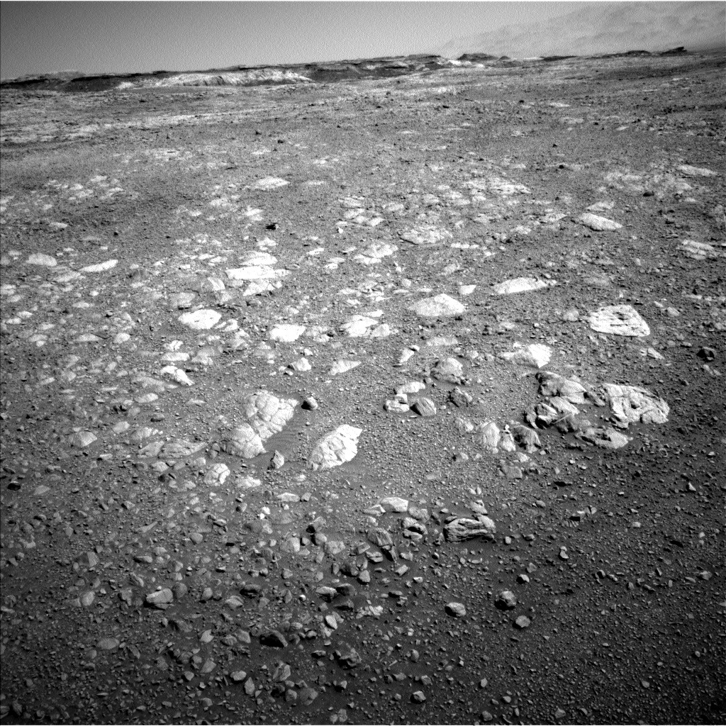
This image was taken by Navcam: Left B (NAV_LEFT_B) onboard NASA's Mars rover Curiosity on Sol 1896 (2017-12-06 06:21:03 UTC).
The bedrock around the rover at this stop is quite rubbly, which made choosing targets for APXS and MAHLI measurements slightly more difficult, as it's often hard to place the arm in contact with rough surfaces. Nevertheless, we planned a very busy 2 sols of science activities! We'll spend Sol 1897 using the robotic arm to collect APXS and MAHLI data on 2 bedrock targets (named "Muck" and "Wick") and a soil target named "Sandness." Overnight on Sol 1897, we'll be conducting a SAM preconditioning activity that will set us up to perform an exciting geochrononology experiment over the weekend on our stored "Ogunquit Beach" sand sample.

Sol 1898 is primarily devoted to remote science. First, we'll take some ENV measurements, including a suprahorizon movie, dust devil survey, Mastcam tau, and line-of-sight extinction. Next, we'll analyze the soil target "Sandwick" with ChemCam, along with an automated AEGIS target. To wrap up our observations, we'll take a series of Mastcam mosaics to capture the local geology, including the sand ripple target named "Loch Eil" and the coarse sandy target named "Ballantrae." We'll also take a few images of the terrain ahead to help assess our drive path along the VRR. We'll remain at this location for the weekend as well.

In other exciting news, Curiosity has crossed into a new section of the science team's geologic map. This means we have a new theme for naming targets, which was reflected in today's target names. The new quadrangle is named after Torridon, a village in the Northwest Highlands of Scotland that is near the Torridonian Supergroup, a geological formation that contains some of the oldest evidence of life of any rocks in the United Kingdom. We hope that this life-inspired Torridon quadrangle will give us good luck as we explore the ancient (and potentially habitable) environments along our trek up Mount Sharp!

December 5, 2017

Sols 1895-1896: Dogleg Left

Written by Dr. Mark Salvatore
Sols 1895-1896: Dogleg Left

After spending the weekend analyzing the chemistry of several interesting targets, the science team has planned yet another action-packed science investigation into Curiosity's next two days on Vera Rubin Ridge. In addition, while Curiosity has spent the last several weeks progressing largely to the south, the team has started to command Curiosity to head more towards the east, doglegging left along the nominal Mt. Sharp Ascent Route (MSAR). Over the next few days, the plan is for Curiosity to investigate what appears to be a small eroded impact crater as well as an erosional window into some visually distinct bedrock outcrops.

Before reaching these targets, Curiosity will conduct some additional investigations of the VRR and the local blocky materials. Sol 1895 has a 1.5 hour block of time dedicated to remote observations of the surrounding terrain. Curiosity will begin with some Mastcam color images of two interesting targets in front of the rover: a blocky exposure of fractured bedrock (named "Mapedi") and a nodular piece of bedrock (named "Koonap"). Afterwards, ChemCam will make active LIBS measurements on three bedrock targets (named "Naute," "Mzamba," and "Nauga," located above the shadow of Curiosity's mast in the provided Navcam image) that are different in tone than other dusty materials in front of the rover, followed by a Mastcam documentation image of this target area.

Following these measurements, Curiosity's arm will be unfurled and she will acquire high-resolution MAHLI images of the Mzamba target in addition to an overnight APXS analysis to derive the rock's bulk chemistry. The next day, before heading towards the eroded impact crater, Curiosity will stow her arm in preparation for the ~1 hour drive to the east. Following her drive, Curiosity will undertake the standard post-drive imaging sequence in addition to acquiring a MARDI image to document the terrain immediately under the rover's belly.

Random Fact of the Day: One of today's ChemCam targets is named "Naute," which is the name of a dam in Namibia along a tributary of the Fish River. Namibia's Fish River Canyon is the largest canyon in Africa, and is a widely visited tourist attraction for its scenic views. The Fish River Canyon is also home to an annual ultra marathon (100 km distance) that travels through the difficult terrain along the margins of the river. As of today, Curiosity only has another 82.174 km to traverse before completing her own ultra marathon!

December 4, 2017

Sol 1892-94: Decisions, decisions

Written by Scott Guzewich, Atmospheric Scientist at NASA's Goddard Space Flight Center
Sol 1892-94: Decisions, decisions

Planning Curiosity's daily activities involves making decisions that impact not only that current day's plan, but also has ripple effects on plans for the next week or even beyond. We had such a decision to make today as some of the most interesting rocks near our planned stop in the Vera Rubin Ridge science campaign were a short distance away. So, we weighed whether to drive a short distance this weekend and study those rocks next week (delaying our existing plans for next week by several days at least), or be content with the rocks we are parked near and drive onward (stopping just left of the small ridge in the foreground at the upper right of this image) to our next destination on the Vera Rubin Ridge. We chose the latter option after determining that these nearby rock targets are sufficiently similar to those a few short meters away and knowing we'll have future opportunities to study some of these bluish-toned rocks at future stops.

With that decision made, Curiosity will be conducting contact science with APXS and MAHLI on two rocks ("Drakensberg" and "Strubenkop") on the first sol of our 3-sol weekend plan. The contact science will be complemented by ChemCam LIBS and Mastcam images on those same rocks and two additional rock targets ("Pongola" and "Third White Ash"). Fittingly, "Third White Ash" is a bright white rock seemingly embedded in the otherwise gravely surface we are driving over. On the third sol of our plan, ENV has a full day of monitoring the skies over Gale Crater for clouds (it's the cloudy time of year on Mars right now) and dust devils, and Curiosity will drive toward our next stop along the Vera Rubin Ridge.

November 30, 2017

Sol 1891: Making Do With What You Got!

Written by Dr. Mark Salvatore
Sol 1891: Making Do With What You Got!

Even before we started planning today's activities, we knew there would be a chance that we would be limited on the amount of data returned to Earth following the previous drive. This turned out to be true, as a data relay from the Mars Reconnaissance Orbiter did not make it down to JPL in time for us to have full Navcam imaging coverage of the area surrounding the rover and in the drive direction. Fortunately, the limited data availability did not significantly influence our capabilities for the day, which is a true testament to the science team, rover planners, and everyone involved in the daily operations!

As the data that are available do not show great bedrock exposures, and because utilizing Curiosity's arm would have likely required all of the data to be downlinked, the science team decided to focus on remote analyses in the immediate vicinity of the rover and then to hit the road for our next stop on Vera Rubin Ridge. The science plan includes long-distance remote imaging with the ChemCam instrument, as well as a Mastcam calibration image and documentation of the automatically selected ChemCam active target executed in the previous plan. Mastcam will also take a multispectral image of the region where Curiosity will be headed over the next few days, in an effort to fully characterize the spectral diversity of this location and to compare with orbital remote sensing data.

Curiosity will then continue her drive to the southeast, headed for a unique patch of terrain that appears interesting in high-resolution orbital data. The hope is to reach this unit on this drive, as that will allow the science team to investigate this interesting region over the duration of the weekend's plan. Because we didn't receive the Navcam data necessary for the rover planners to fully plan the drive, Curiosity will undertake a "guarded drive," where she will autonomously assess the safety of the path ahead and stop the drive if necessary. This is one of those options that is only made available to the mission thanks to the incredible skills of the rover planners and those who developed the mobility software! Following her drive, Curiosity will take her standard sequence of post-drive imaging for targeting, ChemCam will automatically acquire data from a nearby bedrock target, and Mastcam and Navcam will both make environmental and atmospheric observations.

This is only a one-sol plan, as tomorrow is a "soliday" on Mars. So, the science team will pick up planning on Friday, having completed one day's drive and science operations, and hoping for the opportunity for a weekend full of measurements of this interesting region ahead!

LATE BREAKING NEWS: The MRO data ended up arriving just in time to plan a normal drive after all! No need to invoke the "guarded drive" option, although having this capability nearly saved the day!

November 27, 2017

Sol 1889-1890: Back to the Grind

Written by Scott Guzewich, Atmospheric Scientist at NASA's Goddard Space Flight Center
Sol 1889-1890: Back to the Grind

While many of us spent the holiday weekend relaxing with friends and family, Curiosity took no rest on Mars and continued working hard today. The Thanksgiving plan included some unusual activities, but today was back to more typical operations with a "touch-and-go" sol planned. On the first sol of the plan, we scheduled contact science with APXS and MAHLI in addition to a ChemCam observation of a rock target termed "Lyttelton" and then Mastcam imaging of a possible impact crater nearby termed "Beit" (the round-looking feature in the middle of this Navcam image). Following that, Curiosity will drive approximately 40 meters toward our next stop of the Vera Rubin Ridge science campaign.

The second sol of the plan will be dedicated to remote-sensing science including a long-distance image with ChemCam of a fan like deposit closer to Mt. Sharp in addition to Navcam movies searching for dust devils and clouds.

November 21, 2017

Sols 1882 - 1888: Stuffed With Science

Written by Ryan Anderson, Planetary Geologist at USGS Astrogeology Science Center
Sols 1882 - 1888: Stuffed With Science

This week we put together two extra-large helpings of science to get us through the Thanksgiving holiday. The first plan covers sols 1882 through 1886 and much like my plan for after Thanksgiving dinner, will mostly involve sitting in one place and not moving. Instead of a turkey, Curiosity will be cooking a sample of "Ogunquit Beach" in the SAM EGA oven.

Before that happens, we'll use MARDI to look at the ground under the rover to see if anything has moved while we have been sitting at this location. Then, pre-dawn on sol 1883 ChemCam will analyze the rock target "Lebombo" and the soil "Oaktree" to look for evidence of frost. Then, on sol 1885 we have a whole bunch of side dishes in the form of remote sensing. Mastcam will collect multispectral observations of the target "Hexriver" and ChemCam will analyze the targets "Klipfonteinheuwel" and "Klippan." I also advocated for ChemCam to use the RMI to take a closer look at an interesting geologic contact on Mt. Sharp. Mastcam will document all of the ChemCam observations, as well as the ChemCam auto-targeted observation from sol 1878. Mastcam will repeat its clast survey observation from a few days ago to check for any changes, and then APXS will analyze Klippan and Klipfonteinheuwel overnight. Before dawn on sol 1886 ChemCam will once again analyze Lebombo and Oaktree to look for frost and Navcam and Mastcam will take advantage of the early start to make some atmospheric observations.

The second plan for the long weekend covers sols 1886 through 1888. Mastcam will take pictures of the two frost campaign targets, as well as another atmospheric observation. Then ChemCam and Mastcam will take another look at the AEGIS target from sol 1878. This target was given the name "Reivilo" by two of our French colleagues who were on operations today, both named Olivier, who really like the name for some reason. After that, MAHLI will take a closer look at Klipfonteinheuwel and Klippan and APXS will do an overnight calibration measurement.

On sol 1887 Curiosity will finally move on from this spot where we have been camped for a while, collecting some post-drive images to help with targeting next week. Finally, we have an untargeted science block. ChemCam will use AEGIS to automatically pick another target, and we will attempt another one of my observations of Mt. Sharp with the RMI, this time to check for changes on a distant mesa that I have been monitoring. We will wrap up our long weekend with Navcam observations to check for clouds and dust devils, and Mastcam observations to measure the dust in the atmosphere.

We on the Curiosity team are thankful every day that we get to be a part of the exploration of Mars, and next week we'll pick up where we left off as we continue our campaign to explore Vera Rubin Ridge!

November 20, 2017

Sols 1879-1881: Stay frosty!

Written by Claire Newman, Atmospheric Scientist at Aeolis Research
Sols 1879-1881: Stay frosty!

Today's three-sol plan was all about picking interesting targets to explore at our Thanksgiving stopover point, including setting up for our winter 'frost detection' experiments, and getting SAM ready to do some power-hungry analysis while we stay put.

We're only a few sols from southern winter solstice in Gale Crater on Mars, which means it's pretty much the coldest time of year and the best time for Curiosity to try to see water frost on the surface. If we see frost formation, this provides a lot of information for atmospheric scientists like me, who can use it to test models of when and how much frost should form on different types of surfaces, and to better understand how atmospheric water interacts with the surface and subsurface. The problem is that, even in winter, the temperatures in Gale only just dip below the frost point and then only right before dawn. Also, when we've tried looking in previous years, we seem to have been unlucky: the last time we looked for winter frost, the experiment ran on what turned out to be the warmest night of the week. But this just means we have to stay alert to have a good chance of seeing it.

We started today by picking two targets: a small, smooth-topped sand patch, "Oaktree," which sits in a kind of rock circle toward the upper right edge of this Navcam image just before the darker material begins; and a small rock with an east-facing slope, "Lebombo." The sand should have a lower thermal inertia than rock, which means that it cools down more overnight and may be more likely to form frost. But porous sand can also tend to adsorb water instead of the water freezing on its top. So we also chose a rock target with an east-facing slope so it's in shadow for as much of the afternoon as possible, which means it should be able to cool down a little more than other rocks overnight.

Because we only expect the frost layer at this location to be a few microns thick, and to vanish rapidly when temperatures start going up at dawn, it's very hard to detect with cameras. So we'll be using the ChemCam instrument and its Laser-Induced Breakdown Spectrometer (LIBS) to vaporize the top few microns of the surface at night and look for extra hydrogen in the signal, then compare this to daytime measurements of a similar location on the same target.

We'll be making the daytime hydrogen measurements first, on Sol 1879, then in the next plan we'll include nighttime measurements just before dawn on Sols 1883 and 1886, and keep our fingers crossed for seeing a big increase in the hydrogen signal on at least one of the targets!

As well as the frost preparations, our new location stood out from a distance as having lots of color variety in Mastcam images, and we were able to access both brighter and darker blocks with the arm. So in today's plan we'll also be brushing bright target "Hexriver" to remove the top dust layer with the DRT before ChemCam and APXS are done, but the dark target "Zululand" was too small so no brushing will happen first. Meanwhile, Mastcam will be providing imaging of these targets, as well as documenting more of the light-gray/blue rocks that drew us here (target "Natal") and the contrast between the bright and dark toned units on target "Kansa."

We'll be making our usual REMS, RAD, and DAN measurements of the environment, with some additional cloud and sky movies with Navcam and Mastcam just before sunset on Sol 1880 to get a better idea of the aerosols - dust and water ice - around during the frost experiments. And finally, SAM will be preconditioning overnight, preparing to analyze samples from all the way back at the Bagnold Dunes over Thanksgiving.

November 15, 2017

Sol 1875-1876: Sitting on the Boundary

Written by Christopher Edwards, Planetary Geologist at Northern Arizona University
Sol 1875-1876: Sitting on the Boundary

There was no drive in the plan today, so the science team spent the morning identifying and working out a plan to characterize several high-priority science targets. What makes this day a bit different than other days is that Curiosity is sitting right on the boundary between two geologic units observed from orbit. In the next few days Curiosity will drive over this contact between the lighter-toned, lower unit and the darker-toned, upper unit of the Vera Rubin Ridge. These brightness differences observed from orbit are quite striking and at Curiosity's current position, both of these units were visible and reachable by the arm.

In this plan, Curiosity will conduct contact science on a light-toned block dubbed "Fort Brown" and a dark-toned pebble dubbed "Middleton". These targets will have Alpha Particle X-Ray Spectrometer (APXS) data acquired of them, illuminating their major element chemistry. Curiosity will carry out these contact science activities all while parked on a very steep slope, approximately ~19˚, which is about as steep as the steepest road on Earth, Baldwin Street in Dunedin, New Zealand. In addition to the two contact science targets, Curiosity will measure several similarly appearing targets with the remote sensing ChemCam instrument. In the days to come Curiosity will gain a much better understanding of these darker-toned materials as it continues on its journey up Mt. Sharp.

November 15, 2017

Sol 1877 - 1878: The Last Drive Before Thanksgiving

Written by Abigail Fraeman, Planetary Geologist at NASA's Jet Propulsion Laboratory
Sol 1877 - 1878: The Last Drive Before Thanksgiving

The star of tosol's plan was a drive that will likely be our last drive before the Thanksgiving holiday. The science team has a lot of activities we'd like to do that require Curiosity to stay in a single location for several days, so the Earth days that the ops team has off for Thanksgiving will be a perfect time for the rover to get some really good science done without needing input from the ground. As the surface properties scientist (SPS) on shift today, I worked closely with the rover planners to pick a drive target that had the highest likelihood of leaving the rover in a good, stable position while still giving us an exciting workspace for future contact science. In the end, we decided to try to head for an area where we see two different colors of rocks - the typical tan rocks that have been present throughout our time on the ridge as well as some grayer rocks that appear to be unique to the upper part of the ridge. Although it's hard to tell for certain from afar, I'm hopeful this area will be a great place for Curiosity to sit and do science while we humans on the ground enjoy our turkey dinners!

The sol 1877 plan starts off with a science block that includes a Mastcam multispectral observation of a target further up Mt. Sharp called "Table Mountain." We also have ChemCam LIBS observations of two targets, "Brenton" and "Gamtoos," along with the standard Mastcam documentation imaging. We'll then drive to the aforementioned spot, and finish with some post driving imaging.

Sol 1878 will be a busy sol as well, with a morning remote sensing block that contains a ChemCam AEGIS automatic observation, an RMI mosaic of more distant layers on Mt. Sharp, and some Navcam environmental science activities including a dust devil search, suprahorizon movie, and zenith movie. The day ends with a nice afternoon science block that has an atmospheric dust (tau) measurement and a crater rim extinction movie.

November 13, 2017

Sols 1872-1875: A Fashionably Late Data Downlink

Written by Abigail Fraeman, Planetary Geologist at NASA's Jet Propulsion Laboratory
Sols 1872-1875: A Fashionably Late Data Downlink

Because the alignment of a Mars sol versus an Earth day is constantly changing, we sometimes start our planning day a couple hours earlier or later than normal. Today was one of those days where we were scheduled to start the planning process several hours later than normal. However, our actually start time ended up being even a little later than expected because there was an issue with the downlink, which meant we did not receive any data from Mars until ~45 minutes into the planning process. Because of this delay, we didn't have enough time to do a full assessment of the rover's position in order to determine whether it would be stable and safe to move the arm. Fortunately there was still lots of science to do, so we had no problem filling the plan with remote sensing observations plus a small drive that should get us into an even better position for contact science on Monday.

Since today is Friday, we put together a three sol plan that will take Curiosity through the weekend. On the morning of the first sol, we will have a remote sensing block with Mastcam deck monitoring, an observation of the atmosphere with Mastcam, and ChemCam observations on targets "Fort Brown," "Kirkwood," and "Fairfield." We will also take a Mastcam multispectral observation of what might be our contact science target on Monday, a target called "Frisco." Frisco is a light toned rock that's sitting right below a bunch of darker, grayer rocks. This change in rock texture is visible from orbit, and we are excited to investigate it in detail on the ground. In the afternoon, we will take a Navcam mosaic of the sky and a ChemCam RMI standalone image of a soil target named "Fig Tree," which is part of a test of the focus on the RMI imager.

On the second sol of the plan, sol 1873, we will take Mastcam documentation images of the all of the ChemCam targets, a Mastcam tau observation, a crater rim extinction observation, and a dust devil survey. We'll then go for a very short bump to place the rover in the best possible position to do contact science on the area that transitions from smooth, bright rocks, to dark, broken up rocks.

On the final sol of the plan, we will take a morning tau observation to observe how much dust is in the atmosphere, a morning crater rim extinction observation, and some additional Navcam atmospheric images. We will finally finish up the weekend with an automated ChemCam AEGIS observation.