February 15, 2018

Sols 1966-1967: Studying a potential drill target

Written by Kenneth Herkenhoff, Planetary Geologist at USGS Astrogeology Science Center
Sols 1966-1967: Studying a potential drill target

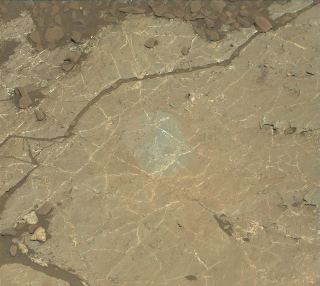
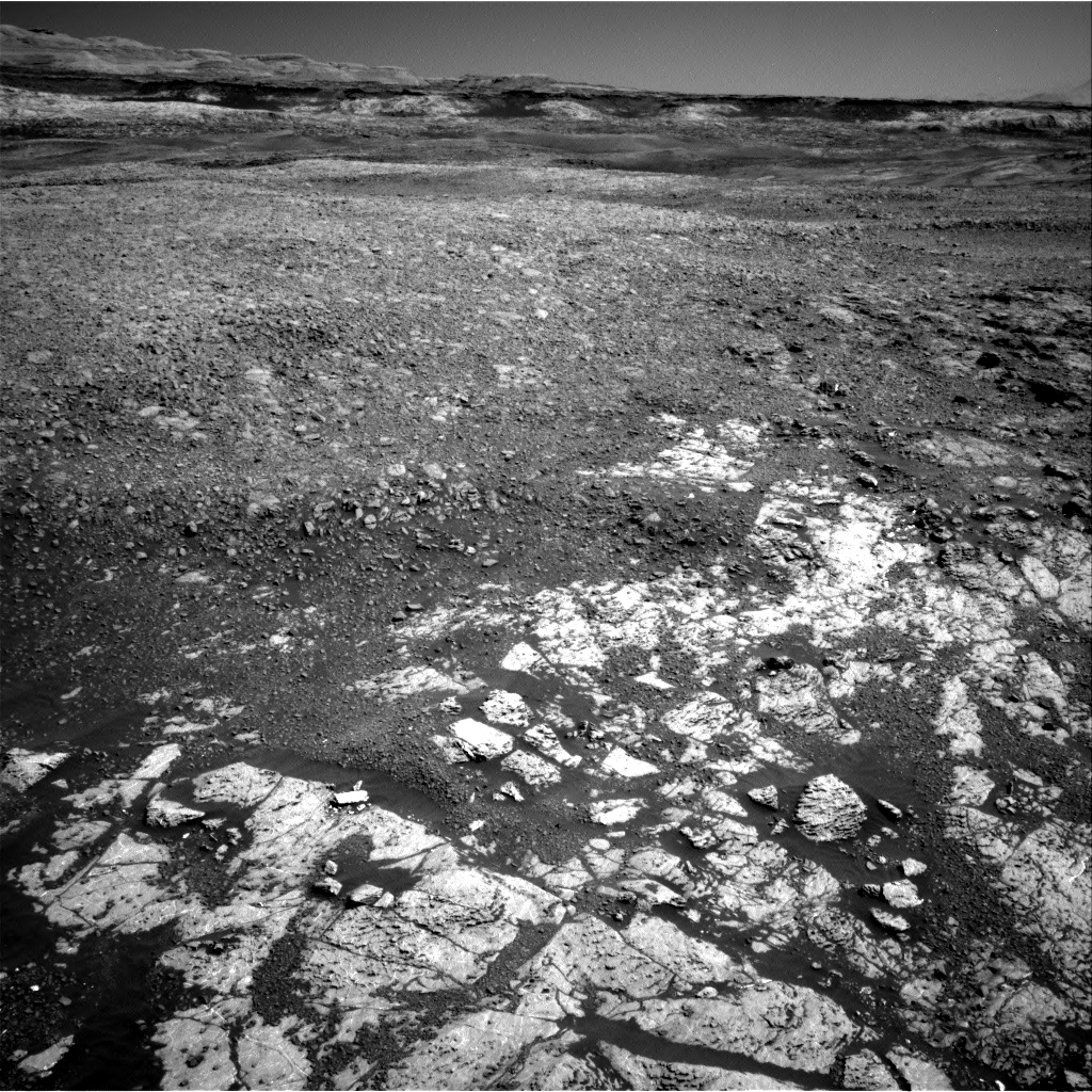
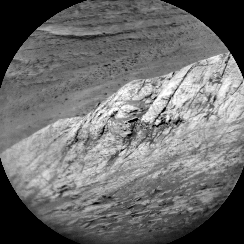
We are planning 2 sols today to get a head start on the holiday weekend planning. We had several options today, including mobility and contact science with or without brushing, which made for an interesting day for me as SOWG Chair. Early in planning, we decided not to move and that our top priority is to brush and investigate a potential drill target just to the right of the Newmachar brush spot. The drill target cannot be finalized today, but the area to be brushed on Sol 1966, centered at "Lake Orcadie," is likely to include the drill target. Before the DRT is used on Lake Orcadie, ChemCam will measure its elemental composition at 9 points in a 3x3 raster and MAHLI will take images from 25 and 5 cm above the surface. ChemCam will also shoot its laser at another contact science target named "Forties," which should clean some of the dust off of the surface before MAHLI and APXS examine it later in the day. MAHLI will also acquire a full suite of images of the brushed spot before APXS is placed on it for an overnight integration.

On Sol 1967, the arm will be moved out of the way so that Mastcam can acquire multispectral observations of Lake Orcadie and "Loch Ba," where there appears to be a change in bedrock characteristics. Then ChemCam and Right Mastcam will observe a vein named "Loch Carron" and sedimentary laminations at "Village Bay." The Right Mastcam will also take an image of Forties before MSL rests and recharges in preparation for the weekend plan.

Unfortunately, we didn't get a successful relay from the Mars Reconnaissance Orbiter (MRO) this morning. We'll be relying on Mars Odyssey instead. Most of the data received from MSL have been relayed through MRO; both Opportunity and Curiosity depend on Mars orbiters to return data. This reminds me how essential the orbiters are to rover operations!

February 14, 2018

Sol 1965: Torrid(on) pace

Written by Michelle Minitti, Planetary Geologist at Framework
Sol 1965: Torrid(on) pace

For the last several months, the science, engineering and operations teams have only met three days a week to plan activities for Curiosity in order to give the engineers more time to focus on bringing the drill back online. This week, we returned to planning five days a week as we continue to traverse east across the "Vera Rubin Ridge" within the Torridon quadrangle, and it feels like the sols (and blogs!) are flying by at rapid speed! Curiosity remained at the same patch of bedrock she has been at all week, a great spot to sit still at while SAM conducts geochronology analyses of the "Ogunquit Beach" sand sample. Before SAM kicks off overnight, Curiosity will acquire a 360 degree mosaic with Mastcam (always a stunning product), and ChemCam will plaster the target "Newmachar" with a rare 16 point raster. These data will provide insight into the chemical variability of Newmachar, which was analyzed on a previous sol with two APXS integrations. The rover will take a brief look skyward for dust devils and clouds, and measurements of the clarity of the atmosphere, and then it's on to SAM. Fingers are crossed for SAM success as the team looks forward to getting back to work again tomorrow!

February 13, 2018

Sol 1964: A Personal Touch

Written by Dr. Mark Salvatore
Sol 1964: A Personal Touch

Like yesterday, today's plan is a bit on the thin side, as the rover's power allotment will be primarily dedicated to activities associated with the Sample Analysis at Mars (SAM) and its preparation for a planned power-hungry experiment in tomorrow's plan. As a result, Curiosity only has about 50 minutes to make observations and measurements of the surrounding workspace, but the team did a great job in packing it full of great observations!

We will first use Mastcam's multispectral imaging capabilities to image yesterday's brushed and analyzed target named "Newmachar," followed by a calibration image, and then two additional multispectral observations of two vein targets named "St. Kilda" and "Benbecula." Mastcam will then perform some additional stereo imaging to assess the workspace and to acquire enough data for the rover engineers to determine whether this area is safe for our first use of the drill since the Fall of 2016! Following these engineer-requested Mastcam mosaics, we will also use the ChemCam RMI high-resolution camera to investigate some interesting targets in our workspace.

It's not everyday that a science team member has a personal connection to a name selected for a target on Mars, but today is an exception. St. Kilda (a target name selected during today's plan) is the name of a small archipelago northwest of Scotland. Before the 1930s, these islands were home to only a few dozen people and, since then, it has become a World Heritage Site and a bird refuge. The islands are largely barren, rocky, and desolate.

What does St. Kilda have to do with a member of Curiosity's science team? St. Kilda is closely tied to Linda Kah, today's Mastcam PUL, a member of the Mastcam team, and a Professor at the University of Tennessee. As her family's story goes, her great great grandfather wanted to purchase St. Kilda and move his family to the archipelago. However, after a family revolt, the purchase and move never took place. As Linda's mother (Ann Ferguson Kah) explained, the family refused to eat solely puffins for the rest of their lives!

After the name was selected for today's target, Linda called her mother to inform her of this connection. Her mother responded "If St. Kilda on Mars is as remote as the St. Kilda in Scotland, your great great grandfather might try to buy that rock as well!"

February 12, 2018

Sol 1963: Getting ready for the SAM geochronology experiment

Written by Lauren Edgar, Planetary Geologist at USGS Astrogeology Science Center
Sol 1963: Getting ready for the SAM geochronology experiment

Over the weekend Curiosity drove ~52 m to the northeast to another patch of gray bedrock. The team is interested in characterizing the gray bedrock to determine if we might want to drill here. But before we can think about drilling again, we need to wrap up our analyses of the cached Ogunquit Beach sample. This means that we need to do some SAM preconditioning today, which is a very power-hungry activity. That also means that there's not a lot of power for other science activities, but we did manage to squeeze in a few contact science activities. I was the SOWG Chair today, and it was exciting to be back to planning nominal sols, which means we'll plan every day this week. However, it was an early slide sol, so the day kicked off dark and early at 6am.

Today's one sol plan starts with the SAM preconditioning activity, which heats up a sample cup in order to prepare for solid sample analysis. In the afternoon, we'll use the DRT to clear a fresh patch of gray bedrock to analyze with MAHLI and APXS at the target "Newmachar," followed by MAHLI imaging of the target "Yesnaby" to investigate a dark gray vein. We'll also acquire some additional workspace imaging to supplement the current coverage and to make sure that we pass our slip checks tomorrow. The plan also includes routine DAN passive and REMS activities. While it was a relatively light plan in terms of science, it's exciting to think about being able to drill again, so we're looking forward to accomplishing the SAM analyses!

February 9, 2018

Sols 1961-1962: Final call

Written by Rachel Kronyak, Planetary Geologist at NASA's Jet Propulsion Laboratory
Sols 1961-1962: Final call

Today we planned for a weekend of activities at the same location we've been at all week. While we're ready and eager to see some new terrain, we had no shortage of interesting science targets to fill our plan.

On the first sol of the weekend plan (Sol 1961), we have a nice long science block that we've filled with a suite of ChemCam observations: LIBS measurements on bedrock targets "Glenfinnan" and "Skara Brae," a long-distance RMI image of the lower slopes of Mount Sharp, and a passive measurement of "Bloodstone Hill." We'll take a Mastcam image to document the LIBS targets and an additional Mastcam image for change detection. When we're at a single location for an extended period of time, we like to take repeat Mastcam images of the same target area across multiple sols. This allows us to compare the images and look for any changes or movement in the field of view. Finally, we'll take a Navcam movie to look for dust devils.

In the evening, we'll take MAHLI nighttime images of Glenfinnan and Skara Brae to take a closer look at some of the small-scale features within the rocks, with the additional benefit of some dust having been cleared by our LIBS observations during the day. The Skara Brae rock target is shown in the MAHLI image above.

On the second sol, Sol 1962, we'll drive to our next VRR location, take some post-drive images, and set ourselves up for an exciting week of contact and remote science!

February 7, 2018

Sols 1959-1960: Old site, new tricks

Written by Michelle Minitti, Planetary Geologist at Framework
Sols 1959-1960: Old site, new tricks

Recovering from the SAM fault proved more challenging than expected, so our planned drive to the patch of pale tan bedrock in the image above did not take place. We took advantage of the fact that we have been parked at this same site for several sols to acquire both new and less-common types of observations. ChemCam's RMI peppered Mt. Sharp with long distance mosaics, imaging a dramatically-layered unit pasted on the flank of Mt. Sharp above us, and various steep slopes to look for evidence of grain motion downhill. In a departure from the normal mid- or late-day imaging blocks available to MAHLI, we planned an early morning arm backbone to get dawn's early light on the target "Arnaboll." Before MAHLI images Arnaboll, ChemCam will shoot it with a raster to clear off dust and measure chemistry, and APXS will perform a long overnight integration to add to our chemistry data from this site. Mastcam will acquire a mosaic of "Soay," a small, unusual depression about 8 m ahead of the rover, and a multispectral observation of two targets previously shot by ChemCam, "Cocksburnpath" and "Harra Ebb." Both these targets have a purplish red color, and the goal is for the Mastcam spectral data to illuminate how (or if!) iron-bearing minerals contribute to those colors.

We were able to fit in multiple sets of environmental observations across both sols, with early morning and afternoon observations of dust in the atmosphere, and movies looking for clouds and dust devils. DAN passive will probe the subsurface around us for over seven hours, as well!

February 5, 2018

Sol 1957-1958: Onward towards gray patch

Written by Rachel Kronyak, Planetary Geologist at NASA's Jet Propulsion Laboratory
Sol 1957-1958: Onward towards gray patch

Over the past several months we've made excellent progress up and along the Vera Rubin Ridge (VRR), taking stunning mosaics and using our instrument payload to examine the local geology. Today we planned for Sols 1957-1958, during which we will continue our VRR investigations and drive further along to our next area of interest. Unfortunately, SAM experienced a minor fault over the weekend, so we'll be delaying those activities - a preconditioning test for an upcoming geochronology experiment - to Wednesday's (Sol 1959) plan.

We'll start off Sol 1957 with two ChemCam LIBS observations on the targets "South Harris" and "Drummock." We got our first taste of Drummock over the weekend with ChemCam and decided to analyze it again to better understand geochemical variations within the rocks around the rover. We'll take Mastcam images to document these ChemCam targets. We'll also take a Mastcam mosaic of "Bloodstone Hill," another target from the weekend plan that warranted further investigation - this area is featured in the black and white RMI image above. Another Mastcam observation in the plan is called a sky column, which we use to periodically monitor material around the Mastcam sunshade. Finally, we'll take a couple of Navcam movies to search for dust devils and cloud activity.

In the afternoon of Sol 1957, we'll drive approximately 60 meters to put us in front of an area identified from orbit to contain an interesting gray patch of bedrock. Following the drive, we will take our standard post-drive images to set us up for remote and contact science on Wednesday.

On the second sol, Sol 1958, our science activities are primarily dedicated to environmental observations. First, we'll use ChemCam to conduct a Passive Sky observation. Next, we'll use Mastcam to take a series of images that help us measure both the amount of dust and the optical depth of the atmosphere. We also have our standard REMS and DAN activities in the plan.

February 2, 2018

Sol 1954-1956: Groundhog Day Across the Solar System

Written by Abigail Fraeman, Planetary Geologist at NASA's Jet Propulsion Laboratory
Sol 1954-1956: Groundhog Day Across the Solar System

Every February 2nd the people of the United States and Canada observe a quirky holiday called Groundhog Day. In the US, the country turns its eyes to Punxsutawney, Pennsylvania to find out whether Punxsutawney Phil, a groundhog, will see his shadow and predict six more weeks of winter. The holiday provides the namesake for a 1993 film in which reporter Phil Conners, brilliantly portrayed by Bill Murray, finds himself in a time loop while covering the events in Punxsutawney.

Planning Curiosity's activities on Februrary 2nd, 2018, aka sol 1954 - 1956, felt a little bit like Groundhog Day on Mars. Unfortunately the uplink to the rover for the sol 1952 - 1953 failed, so we unexpectedly found ourselves in the same location as Wednesday. The Sol 1953 part of the plan was planned yesterday and uplinked to the rover early this morning. Never wanting to lose missed opportunities, we made a plan today that will recapture the missing Sol 1952 observations we were hoping to get in Wednesday's plan, and also adds a few new things into the mix given additional time that is available to us.

The biggest activity of the plan is setting up to do a SAM geochronology experiment next week. Because this activity will be so power intensive and requires ground in the loop between certain steps, we were not driving in tosol's plan. We will instead do additional remote sensing with our extra time.

Besides the SAM preparation activities, the main science in today's plan is focused on characterizing the broken up rocks in front of us, which are the typical targets on the top of Vera Rubin Ridge. We will do MAHLI contact science in the morning of the first sol on targets "Skara Brae," "Glen Roy," and "Drummock." We will also take an APXS observation of Glen Roy and Skara Brae. We have a remote sensing block on the second sol of the plan. In this block, we will collect ChemCam LIBS observations of Glen Roy, "Harra Ebb," and "Cocksburnpath," and an RMI mosaic of "Bloodstone Hill." All of the LIBS observations will be accompanied by Mastcam documentation images. We will take additional Mastcam images of two aegis targets from the previous plan, a documentation of our surrounding landscape with multispectral filters, an outcrop named "Scalpay," and a large 37x2 mosaic of the crater rim. The third sol of the plan is a morning science block with a Mastcam tau, a crater rim movie, a Navcam zenith movie, a Navcam suprahorizon movie, and a Navcam 360 degree sky survey.

February 1, 2018

Sols 1952-1953: Another "touch and go"

Written by Ken Herkenhoff, Planetary Geologist at USGS Astrogeology Science Center
Sols 1952-1953:  Another "touch and go"

Along with many of my MSL colleagues, I'm attending our semi-annual science team meeting, enjoying the presentations and discussion of recent results and plans for the future. Meanwhile, today's tactical operations team is planning another "touch and go" for Sols 1952 and 1953. The "touch" includes a short APXS integration and a MAHLI full suite on a rock named "Skara Brae," and a single MAHLI image of a grey cobble dubbed "Drummuck." Then ChemCam and Right Mastcam will observe a patch of reddish bedrock called "Harra Ebb" and the ChemCam RMI will acquire a mosaic of a distant target named "Bloodstone Hill." Right Mastcam will also observe the Sol 1951 AEGIS targets and acquire a small mosaic of "Dulce Vallis," near the rim of Gale Crater. The "go" (drive) will be followed by the usual post-drive imaging and DAN active measurement.

Late in the morning of Sol 1953, AEGIS will autonomously select two more ChemCam targets, Mastcam will measure the amount of dust in the atmosphere, and Navcam will search for dust devils. Late that afternoon, Navcam will watch for clouds overhead and measure variations in sky brightness at various azimuths. Finally, ChemCam will acquire calibration data before the rover sleeps in preparation for the next plan.

Today is my father's 88th birthday and the 60th anniversary of the launch of the first US satellite, Explorer 1. This reminds me how fortunate his generation is to have witnessed the historic first steps into space and the many spectacular missions of exploration that followed. When he was a child, very little was known about Mars, and many believed that it had canals built by civilized Martians. Missions to Mars have shown no signs of civilization, but the search for evidence of past and present life on Mars continues. We are all lucky to live in such exciting times!

January 29, 2018

Sol 1947-1949: I love it when a plan comes together

Written by Ryan Anderson, Planetary Geologist at USGS Astrogeology Science Center
Sol 1947-1949: I love it when a plan comes together

Going in to planning today, there was a concern that we would run up against constraints on power and complexity that might force us to eliminate some of the science we wanted to do. Thankfully, that did not end up being the case and nothing had to be removed! I was especially happy about this because this morning I noticed that the single full-resolution Navcam frame of Mt. Sharp that we received (shown above) included a location that I wanted to image with ChemCam's RMI. So even though I was on ChemCam downlink, I also managed to work with the uplink team to get a RMI observation into the plan.

The weekend plan begins on Sol 1947 with a Mastcam observation of the target "Montrose", the first of a pair of images intended to watch for any changes in the soil at this location. After that, ChemCam will do a calibration observation and two analyses of targets "Thurso" and "Loch Tay," followed by Mastcam documentation of those targets. In the afternoon of Sol 1947, MAHLI will take pictures of Thurso and Loch Tay. APXS will do a short measurement of Thurso, and then an overnight measurement of Loch Tay.

On Sol 1948, ChemCam will do the long-distance imaging observation that I requested, followed by a measurement of "Loch Scridain". Mastcam will document the ChemCam target, and then has several mosaics of the target "Harris Bay". In the late afternoon on Sol 1948, ChemCam and Mastcam will do some "flat field" observations of the sky. Flat fields are used to check for, and potentially correct for, things like dust on the optics of a camera.

On Sol 1949, Mastcam and Navcam have some atmospheric observations to measure the amount of dust in the atmosphere, and Mastcam will follow up with a second observation of "Montrose" to look for changes. Then Curiosity will do a short drive, and collect post-drive imaging so we can plan next week.

The MSL science team will be meeting in California next week, but while we talk about all the data we already have, we will do our best to keep Curiosity busy collecting more!