February 8, 2021

Sols 3013-3014: It's Freezing Cold…

Written by Susanne Schwenzer, Planetary Geologist at The Open University
A color image of Mars taken by the Mars Hand Lens Imager on NASA's Curiosity.

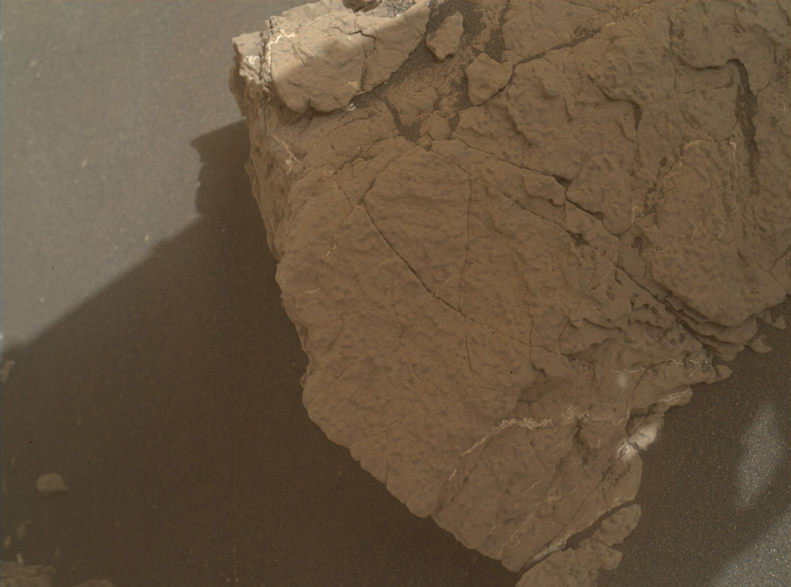
NASA's Mars rover Curiosity acquired this image using its Mars Hand Lens Imager (MAHLI), located on the turret at the end of the rover's robotic arm, on Sol 3024 of the Mars Science Laboratory Mission. Credit: NASA/JPL-Caltech/MSSS. Download image ›

It’s freezing cold right now here in Europe, with temperatures just below 32 F (0 °C), which sparked me to look at the weather report from Gale crater, provided by REMS, our weather station. I find that temperatures are between 21 and -101 F at Gale crater at the moment, that’s between -6 and -74 in degree Celsius. So, Mars is a lot colder than Earth in front of my window right now. But how cold is it compared to Earth temperatures more general? Well, in the UK, where I am located, the coldest day ever recorded was -17 F (-27.2 °C) in January of 1982, but there are much colder temperatures recorded on Earth, with the record being −128.6 °F (−89.2 °C) measured in July 1983 at the Soviet Vostok station in Antarctica. Are you feeling as cold as I am now?

Curiosity will continue to measure the temperatures regularly, and you can look at the weather report here: https://mars.nasa.gov/msl/weather/. In today’s plan there are also some atmospheric observations, looking at the crater rim and the horizon to investigate the dust load of the atmosphere, and conducting a dust devil survey.

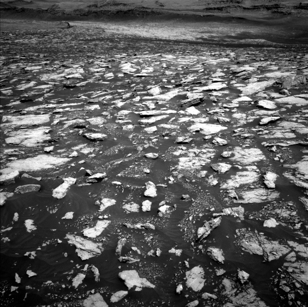
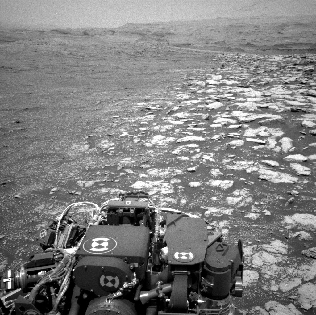
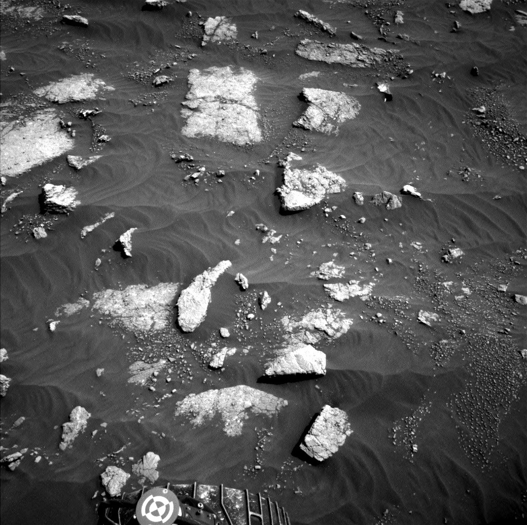
In the last blog you saw the rather rubbly and broken up terrain the rover navigates at this location, and a close up, taken by MAHLI is shown in this blog. The bedrock is reddish and it has the white veins that we are by now so familiar with. What its exact chemistry is and how that compares to other locations is APXS’s task to find out. In today’s plan, APXS is therefore investigating the target "Labouquerie."

ChemCam is looking into the distance with a long distance RMI investigating target "Monbazilliac." Mastcam does double duty on the target Azerat, with stereo and multispectral imaging. It also adds a workspace image and a stereo mosaic on a ridge, target name "Grand Brassac," in the distance to its imaging work.

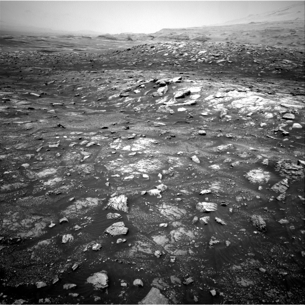
We are not here for long, though, as the next drive will immediately follow those investigations, so stay tuned for the next view of the rubbly landscape as early as tomorrow!

February 5, 2021

Sols 3024-3025: Roving Through the Rubble

Written by Melissa Rice, Planetary Geologist at Western Washington University
A black and white view of Mars

This image was taken by Left Navigation Camera onboard NASA's Mars rover Curiosity on Sol 3022 (2021-02-05 06:20:27 UTC). Credit: NASA/JPL-Caltech. Download image ›

Curiosity has just crossed the contact between two rock types: the fractured intermediate unit and the rubbly sub-unit. This weekend, Curiosity’s driving will be entirely within the rubbly material. It will be slow going because the rover has to navigate carefully around the jumble of pointy rocks – this stuff is called “rubbly” for a reason!

We don’t know exactly what is causing the rubbly character of the rocks here, and why they have weathered so differently from the adjacent, less-broken-up outcrop. As we drive through it, we plan to take frequent measurements of the chemistry and textures to better understand the unit’s origins. Today, the team selected two rubbly blocks to study with APXS and MAHLI: targets “Coutures” and “Biron.” ChemCam will also acquire a mosaic of RMI images over the rock “Sarrazac,” and Mastcam will document some of the blocks nearby with vertical faces.

Looking forward, Curiosity is heading to the sulfate unit, in the direction of the bright, smooth rocks seen towards the top of the Navcam image above. This weekend, Mastcam will be taking a panorama and multispectral images that cover the base of this sulfate unit and the cliff face seen on the left. These images will help the science team decide exactly where to direct Curiosity as the rover rambles through this rocky rubble.

February 3, 2021

Sols 3022-3023: At the Contact

Written by Kristen Bennett, Planetary Geologist at USGS Astrogeology Science Center
Parts of Curiosity rover are visible in this image of Mars

This image was taken by Right Navigation Camera onboard NASA's Mars rover Curiosity on Sol 3020. Credit: NASA/JPL-Caltech. Download image ›

Curiosity is currently within the fractured intermediate unit and in the previous drive the rover reached a contact between two sub-units. On one side of the contact there are many large broken pieces of bedrock (rubbly; left side of above image), while the other side is smoother (right side of above image). In this plan we are characterizing the contact before driving into the rubbly sub-unit.

Several Mastcam mosaics are planned that span across the contact so we can document this view. There is also a contact science target, “Tamnies,” that will be our last contact science target in this sub-unit before the rover crosses into the rubbly fractured intermediate unit. Both an APXS observation and MAHLI images are planned at Tamnies, in addition to a Mastcam multispectral observation.

The plan includes a Deimos transit observation in the afternoon. In this observation Mastcam will take several images to capture Mars’s moon Deimos as it moves across the sun.

A ~25-meter drive is planned for Curiosity to venture into the rubbly fractured intermediate unit and continue traversing towards the next key target: the sulfate unit.

February 2, 2021

Sols 3020-3021: Saying Goodbye to the Fractured Intermediate Unit

Written by Ashley Stroupe, Mission Operations Engineer at NASA's Jet Propulsion Laboratory
Mars is seen in color in this upside image of Mars

NASA's Mars rover Curiosity acquired this image using its Mars Hand Lens Imager (MAHLI), on Jan. 31, 2021. This image is upside-down because of the orientation of MAHLI when it was taken. Credit: NASA/JPL-Caltech/MSSS. Download image ›

Today we’re doing another touch-and-go, fitting in a little bit of everything. And while we are planning for tomorrow on Mars, the science team is also busily analyzing the results of the triboelectric experiment that Curiosity did over the weekend (see the sol 3017 blog for details), looking at the images like the upside-down MALHI (shown), which are both beautiful and important for science. The image is upside-down because of the orientation of MAHLI when it was taken – the arm was extended almost straight up, like a periscope, to get the desired angle of view; and to point back toward the sands from that position, the MAHLI camera needed to be upside-down.

First up in the plan is contact science with MAHLI and APXS on a bedrock target named “Lunas,” as part of our regular tracking of bedrock composition and changes. The target was a little tough to pick in order to avoid some discolored areas and the veins and try to get a good representation of the bedrock itself.

After we stow the arm, the rover will take several targeted science observations, including a ChemCam RMI mosaic of the sulfate unit and a large Mastcam mosaic of the contact with the sulfate unit. We are also doing some environment observations, including a crater rim extinction and a long dust devil movie.

The drive in today’s plan is aiming to park us just before we transition out of the fractured intermediate unit (and before we enter the fractured rubbly unit). Once we get back into the rubbly unit, the driving will get a little bit tougher for the Rover Planners, because there are a lot more small and medium sized rocks that we’ll need to avoid to minimize wheel wear. But, for this short drive of about 25 meters, the terrain is flat and clear of major hazards. The plan is to park where we can do one last contact science observation of this unit before leaving it behind. We are taking advantage of the short distance of the drive and the arm will be unstowed at the parking location. We’ll be taking extra workspace and drive direction imaging at this location as our last look at the unit.

On the second sol of the plan, we have more of our standard environmental observations, including another dust devil movie and a suprahorizon movie with navcam in the morning, and a long Mastcam sky survey and solar tau in the afternoon. We’re also throwing in a late-afternoon Navcam optics monitoring activity to help us track the dust on the cameras.

February 1, 2021

Sols 3017-3019: Hoping to Make a ‘Shocking' Discovery

Written by Melissa Rice, Planetary Geologist at Western Washington University
An image of Mars

This image was taken by Right Navigation Camera onboard NASA's Mars rover Curiosity on Sol 3015 (2021-01-29 02:34:16 UTC). Credit: NASA/JPL-Caltech. Download image ›

In the weekend plan for sols 3017-3019, Curiosity will attempt a novel experiment to witness the “triboelectric effect” for the first time on Mars. What is the triboelectric effect? Certain materials build up an electrostatic charge when they move around, and when that buildup of electricity discharges, it can cause a spark. You may know the triboelectric effect as the static cling – and occasional shocks – from clean clothes fresh out of the dryer.

On Mars, no clothes are tumbling in dryers, but sand grains are tumbling in the wind, and they could build up a triboelectic charge. When that electricity discharges, it could ionize gases near the surface, which could influence Mars’ atmospheric chemistry. If the discharges occur at night, it may be possible to see a spark above the sands. In the likely event we don’t see any flashes of light, we’ll still be able to place constraints on how much this process occurs at Gale.

So for this weekend, the team planned a series of MAHLI images to be taken at night, staring at the large sand deposit to the south (which Curiosity had recently investigated at the “Sands of Forvie” location, see the blog for Sols 2989-2991). We can’t be certain if the triboelectic effect will be visible to MAHLI – but the possibility of capturing it has certainly sparked our curiosity!

In addition to the triboelectric experiment, the science team also plans to use APXS and MAHLI to study the bedrock target “Neuvic,” Mastcam to take multispectral images of “Neuvic” and the adjacent bedrock target “Vezere,” in addition to panoramic images of the landscape, and Navcam to take movies to search for dust devils. For sol 3018, the team planned a long drive for Curiosity to the east, making steady progress towards the sulfate-bearing strata of Mt. Sharp.

January 27, 2021

Sols 3015-3016: Can You Dip Your Toe in When It's Always Cold and Dry?

Written by Scott Guzewich, Atmospheric Scientist at NASA's Goddard Space Flight Center
Parts of the Curiosity rover are visible in this Mars panorama

This image was taken by Left Navigation Camera onboard NASA's Mars rover Curiosity on Sol 3013 (2021-01-27 00:07:33 UTC). Credit: NASA/JPL-Caltech. Download image ›

Today Curiosity is sitting on a geological contact within the “fractured intermediate unit” and we’re investigating the “rubbly” portion of that unit. This Navcam image clearly shows the boundary between the smooth and pebbly portion of the unit and the large blocky portion we are investigating on this brief “toe dip” into the rubbly area. We will perform contact science with APXS and MAHLI on one of these blocks, termed “Beaupouvet,” and take Mastcam multispectral and mosaic images of it and other rocks in the workspace. ChemCam is acquiring passive spectra of its calibration target while the team investigates an issue with some observations last week. After contact science, we’ll drive back into the smoother pebbly portion of the unit as we continue to head for the sulfate unit higher on Mt. Sharp. On the second sol of our plan, we’ll have a sequence of activities to search for and image dust devils. We’ll also look for evening clouds, which typically become more abundant this time of year as we approach the northern hemisphere spring equinox on Mars.

January 25, 2021

To Dip a Toe or Not To Dip a Toe…

Written by Susanne Schwenzer, Planetary Geologist at The Open University
One of Curiosity's wheels is visible on this image of Mars

This image was taken by Left Navigation Camera onboard NASA's Mars rover Curiosity on Sol 3011. Credit: NASA/JPL-Caltech. Download image ›

Today’s title image shows how diverse the area is that Curiosity is currently travelling through, with a part of a wheel for scale. A close look such as this one reveals all the different textures of rock surfaces, sets of ripples, some big rocks and small pieces of rock accumulated in patches.

Today’s discussions started with some strategizing as to if to make a short excursion, nicknamed the "toe dip," in tosols’s plan or in the weekend plan. This "toe dip" is a very short deviation from our current drive route to investigate a nearby unit, in fact the contact between the unit Curiosity is standing on top of right now and a neighboring unit. These contacts between two units are always of high interest to any geologist. At contacts, we can learn so much about the succession of processes that shaped the geologic environment at the time the sediments were laid down, and well before they became rocks. Or, in fact, well before at least the upper one of them became a rock, because at a contact, a geologist can find out, if the upper unit was deposited before or after the lower unit became a hard rock. And of course, we can see, if the laying-down of the upper unit had any influence on the lower unit, or if the upper unit includes pieces of the lower unit, or if the upper unit sealed off some water flow from below and caused mineral precipitation – just to name a few of the things geologist look out for at a contact between two units.

But back to today’s plan: Yes, we decided to drive to the area for the toe dip tosol. APXS and MAHLI are investigating a target “Champagnac,” which is a large piece of rock in the multitude of options in today’s workspace, which had made itself interesting by its darker color, which could indicate a change in chemistry from the usual-colored rocks we have been investigating lately. Mastcam and the Navcams are again getting very busy this sol, with the usual workspace survey and post drive imaging to prepare the next sol. On the science activities, Mastcam will investigate the area around a target “Marnac” by executing an investigation in multispectral mode with added stereo images, as well as perform a mosaic at the area the rover will approach for the ‘toe dip’ to the contact with the nearby unit with a set of seven images.

Of course, Curiosity is doing her regular atmospheric monitoring. For this, she will image across the floor of Gale crater to see how much dust there is in the air between the rover and the distant crater rim, and she'll image toward the sun to measure the dust load in the atmospheric column. In addition, she will do image sequences to survey for clouds, dust devils, and dust lofting over the "Sands of Forvie." Other regulars include MARDI, which takes its usual image after the drive, and DAN, which surveys for water in passive mode. Another busy sol on Mars – and off she goes to dip a toe onto the contact nearby.

January 25, 2021

Sols 3010-3012: Bonjour, Nontron (Mars)

Written by Ashley Stroupe, Mission Operations Engineer at NASA's Jet Propulsion Laboratory
A view of Mars

This image was taken by Right Navigation Camera onboard NASA's Mars rover Curiosity on Sol 3008. Credit: NASA/JPL-Caltech. Download image ›

Curiosity is continuing to make her way through the fractured intermediate unit toward the sulfate unit. After an 80-meter drive in our last plan, Curiosity has officially crossed into the new quadrant “Nontron” and parked with this amazing view (see image). And after more than 1000 sols visiting Scotland, Curiosity is now learning French! There are more details about this new Nontron quadrant in the Sol 3007 blog.

Curiosity will be starting off the weekend taking a 360-degree, 120-frame Mastcam panorama of this spectacular location, along with some more close-up images of rocks in the rover’s vicinity. These other observations include a bright-red rock in the workspace called “La Rogue Gageac” and some pebbles (to look at movement and stratigraphy). Later on the afternoon first sol, Curiosity will be doing contact science on two targets, La Rogue Gageac and one a normal-colored rock named “Gageac et Rouillac.” We’ll brush La Rogue Gageac in order to make sure we are examining a clean surface. Then, both targets will be examined with MAHLI and APXS. This will help us to understand the local variability, as well as fit in to our regular cadence of observations to track changes in the geology and mineralogy along our route.

On the second sol of the plan, Mastcam will do an additional multispectral image of La Rogue Gageac. Then, MAHLI will take a close-up look at the middle wheel in order to examine recent changes in wear seen in recent imaging. The wear doesn’t present a risk or concern, but these additional images from another angle will provide more data and insight to the engineering team. Once the arm is stowed, Curiosity will resume the trek toward the sulfate unit. Today’s drive is about 50 meters along our strategic route. The terrain is challenging, being ridged and rocky, giving the rover drivers a fun challenge. The drive is skirting around a ridge that we can’t see behind, in order to remain mostly on the terrain that we can see and characterize. The rover will be driving through a patch that is occluded from our current location, so the rover planners are using guarded driving, which allows Curiosity to evaluate the path ahead for hazards.

The third sol will include a lot of untargeted observations, mostly geared toward environmental science. Observations include early morning line-of-sight, zenith, superhorizon, and dust devil images with Navcam, a solar Tau and crater rim extinction by Mastcam, and a lot of DAN, RAD, and REMS as always.

January 20, 2021

Sols 3007-3010: Rocketing East

Written by Michelle Minitti, Planetary Geologist at Framework
Part of Curiosity rover is visible in this image of Mars

This image was taken by Left Navigation Camera onboard NASA's Mars rover Curiosity on Sol 3005. Credit: NASA/JPL-Caltech. Download image ›

Long before Curiosity landed on Mars, the science team mapped the landing ellipse covering the area within Gale crater that the combined efforts of Jet Propulsion Laboratory engineers, orbital mechanics, and atmospheric dynamics would lead us to touch down within. To divide the work of mapping among the team, the landing ellipse was divided into quadrants, squares 1.5 km on a side. Each quadrant was named after a significant geologic terrain on Earth, where geologists also divide the terrain they explore into quadrants. The practice of dividing the terrain Curiosity explores into quadrants continued after Curiosity departed the landing ellipse, to not only help focus mapping and path planning efforts, but to serve as a source of the names we assign to targets imaged, shot, drilled, or scooped.

We entered the "Torridon” (Scotland) quadrant on Sol 1896, and save a northward jaunt back into the “Biwabik” (Minnesota, USA) quadrant for 70 or so sols, we have remained in the Torridon quadrant. Over this time, all the targets we have named have required pages and pages of place names from Scotland (and Scotland adjacent) provided mostly by our team member Dr. John Bridges (University of Leicester). Those lists have produced great target names like “Muckle Flugga,” “Oban,” and “Bogmill Pow.” But in the drive in today’s three sol plan, we are due to exit the Torridon quadrant and enter the “Nontron” (France) quadrant where our French ChemCam teammates will help us with our target pronunciations. The Nontron quadrant name is particularly appropriate for the clay-bearing terrain we find ourselves in, as Nontron is the type locality for a clay mineral called nontronite. Nontronite is part of the smectite group of clays, which are the most common types of clays on Mars. The science team decided to send the Torridon quadrant out with a bang - literally - using the name “Saxa Vord Spaceport” for a ChemCam target. Using the name of an in-the-works satellite launch site in northern Scotland also represents the speed at which we are rocketing toward the sulfate unit, having completed a nearly 100 meters drive in the last plan, and looking forward to a ~75 meters drive in this plan.

While undoubtedly the coolest name in the plan, Saxa Vord Spaceport was far from the only target name used in our busy plan. ChemCam will also shoot bedrock targets “Easthouses” and “Jarishof,” and one of the fields of pebbles (“Whaligoe”) that we commonly see distributed in discreet patches (like in the image above). APXS, MAHLI and Mastcam will get a closer look at Easthouses after ChemCam shoots it. Mastcam also planned images of the terrain around us near and far. Mosaics of “Sandsayre” and “Rackwick” to rover left and right will record bedrock textures and structures, a mosaic of the more distant “Cromalt Hills” will capture their vertical structure, and yet another mosaic will image the contact between the fractured intermediate unit we are currently driving through and the rubbly version of this unit that we recently explored.

On each sol of the plan, DAN will seek the signal of hydrogen in the ground below us using both their active and passive modes, REMS will record the weather conditions, and RAD will monitor the radiation environment. These systematic measurements are complemented by images from Navcam and Mastcam that will hopefully capture clouds and dust devils and will measure the amount of dust in the skies above all the quadrants in Gale.

January 19, 2021

Sols 3003-3006: On the Road Again

Written by Vivian Sun, Planetary Geologist at NASA's Jet Propulsion Laboratory
This image was taken by Chemistry & Camera (ChemCam) onboard NASA's Mars rover Curiosity on Sol 3001.

This image was taken by Chemistry & Camera (ChemCam) onboard NASA's Mars rover Curiosity on Sol 3001. Credits: NASA/JPL-Caltech/LANL. Download image ›

We began planning today with the good news that we received some of the previously expected data and could plan “targeted” observations on specific targets identified in the new images. One catch was that higher-resolution workspace images, a pre-requisite to using the rover arm’s Dust Removal Tool (DRT), were not received in time for today’s planning, but we were still able to plan a plan chock full of remote sensing and contact science without the DRT. Today’s plan covered four sols, one sol longer than our usual 3-sol weekend plans due to the US holiday on Monday.

The APXS and MAHLI target of choice this weekend is a target called “Tomb of the Eagles,” which will give us high-resolution composition and image data over the typical bedrock at this location. ChemCam will also acquire measurements on Tomb of the Eagles, which is useful for comparing observations from different instruments on the same target. Other planned ChemCam observations of “Geocrab,” “Parallel Roads,” and “Watch Stone” also aim to characterize the compositional variability of the local bedrock, including nodular and veiny textures that have been previously observed in this area (see image above). The latter two targets were selected for especially long rasters (20 points instead of the usual 5-10) in order to better characterize chemical variability in these rocks. Mastcam will also be busy this weekend, taking documentation images of automated ChemCam AEGIS observations from the previous plan as well as of a possible meteorite, “Obar Dheathain.” We will also take two larger mosaics of the local landscape in stereo coverage, which is useful for assessing the 3-dimensional properties of these rocks. One mosaic is on the exposed outcrop right next to our workspace; these outcrops appear as ridges in orbital images and on-the-ground images will help us determine how these ridges formed. The second mosaic looks farther away at the contact between the fractured intermediate unit and the rubbly unit on top of it. Other activities in this weekend plan include a routine APXS calibration activity, and many atmospheric observations monitoring the environment, including Navcam movies, dust devil surveys, and Mastcam taus. On Sol 3005, we will drive and continue our path to the sulfate-bearing unit. On Sol 3006, we will let Curiosity take a breather, with just REMS atmospheric measurements and basic engineering activities in the plan. After this long weekend, Curiosity and her planning team will return refreshed for more planning next week!